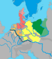
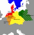
File:Germanic dialects ca. AD 1.png
Từ Wikimedia Commons, kho lưu trữ phương tiện nội dung mở
Bước tới điều hướng
Bước tới tìm kiếm

Kích thước hình xem trước: 536×600 điểm ảnh. Độ phân giải khác: 215×240 điểm ảnh | 429×480 điểm ảnh | 687×768 điểm ảnh | 915×1.024 điểm ảnh | 2.067×2.312 điểm ảnh.
Tập tin gốc (2.067×2.312 điểm ảnh, kích thước tập tin: 703 kB, kiểu MIME: image/png)
Thông tin tập tin
Dữ liệu có cấu trúc
Chú thích
Chú thích
Ghi một dòng giải thích những gì có trong tập tin này
Any autoconfirmed user can overwrite this file from the same source. Please ensure that overwrites comply with the guideline.
| Miêu tảGermanic dialects ca. AD 1.png |
English: The distribution of the primary Germanic dialect groups in Europe around AD 0-100:
|
||
| Ngày | |||
| Nguồn gốc | Based on Germanic Groups ca. 0CE.jpg by Varoon Arya (source used is König, Werner (2001). dtv-Atlas Deutsche Sprache. München: Deutscher Taschenbuch Verlag 2001. ISBN: 3-423-03025-9; pp. 46, 52.), The Indo-European Languages, A G Ramat, P Ramat. Taylor & Francis, 1998. ISBN 041506449X. A Culture Cycle from the Early and Middle Bronze Age. Jan Dobrowski. Archaeologia Polonia. XVI, 1975, Hansjörg Küster: Geschichte des Waldes. Von der Urzeit bis zur Gegenwart. Beck, Munich, 1998, and, The Early Germans, Malcolm Todd (2004). | ||
| Tác giả | AKAKIOS | ||
| Giấy phép (Dùng lại tập tin) |
Tác phẩm này được phát hành theo giấy phép Creative Commons Ghi công–Chia sẻ tương tự, các phiên bản 2.5 Chung, 2.0 Chung, và 1.0 Chung.
|
||
| Phiên bản khác |
|
Lịch sử tập tin
Nhấn vào ngày/giờ để xem nội dung tập tin tại thời điểm đó.
| Ngày/Giờ | Hình xem trước | Kích cỡ | Thành viên | Miêu tả | |
|---|---|---|---|---|---|
| hiện tại | 10:28, ngày 30 tháng 5 năm 2024 |  | 2.067×2.312 (703 kB) | Vlaemink (thảo luận | đóng góp) | According to Seebold et al. the Rhine Weser dialects were spoken further east during the 1st century CE. The previous version seems to show a situation closer to the 3rd and 4th century. |
| 15:20, ngày 14 tháng 4 năm 2022 |  | 2.067×2.312 (776 kB) | Mårtensås (thảo luận | đóng góp) | Reverted to version as of 11:11, 11 January 2022 (UTC) | |
| 15:18, ngày 14 tháng 4 năm 2022 |  | 2.067×2.312 (767 kB) | Mårtensås (thảo luận | đóng góp) | Minor olor fix | |
| 11:11, ngày 11 tháng 1 năm 2022 |  | 2.067×2.312 (776 kB) | Vlaemink (thảo luận | đóng góp) | This map seems to show a situation closer to 400-600 CE than 1CE, according to Seebold (Seebold, Elmar (2003): Die Herkunft der Franken, Friesen und Sachsen) the Northsea Germanic territories at this point in time did not yet include the Northern Netherlands. | |
| 15:43, ngày 15 tháng 10 năm 2018 |  | 2.067×2.312 (791 kB) | Ax quinque (thảo luận | đóng góp) | Reverted to version as of 09:48, 4 May 2018 (UTC) Reverted to more detailed version of the map by AKAKIOS. | |
| 11:30, ngày 22 tháng 8 năm 2018 |  | 419×431 (15 kB) | Shmurak (thảo luận | đóng góp) | Reverted to stable version | |
| 09:48, ngày 4 tháng 5 năm 2018 |  | 2.067×2.312 (791 kB) | E-960 (thảo luận | đóng góp) | Reverted to version as of 20:02, 5 December 2017 (UTC) The other map's boundaries look suspiciously like the boundaries of the Greater Third Reich (see talk page) | |
| 11:12, ngày 30 tháng 3 năm 2018 |  | 419×431 (36 kB) | Til Eulenspiegel (thảo luận | đóng góp) | Reverted to version as of 17:44, 5 December 2017 (UTC) used on 3 pages in am., we never wanted a new version, just make a new file instead of overwrite this one we use | |
| 20:02, ngày 5 tháng 12 năm 2017 |  | 2.067×2.312 (791 kB) | AKAKIOS (thảo luận | đóng góp) | Reverted to version as of 20:06, 3 December 2017 (UTC) Assuming good faith, while waiting on sources for claims. | |
| 19:58, ngày 5 tháng 12 năm 2017 |  | 2.067×2.312 (816 kB) | AKAKIOS (thảo luận | đóng góp) | Reverted to version as of 07:50, 4 December 2017 (UTC) |
Bạn không được phép ghi đè tập tin này.
Trang sử dụng tập tin
11 trang sau sử dụng tập tin này:
- User:Chumwa/OgreBot/Travel and communication maps/2017 December 1-10
- User:Chumwa/OgreBot/Travel and communication maps/2017 February 10-18
- User:Chumwa/OgreBot/Travel and communication maps/2017 November 21-30
- User:Chumwa/OgreBot/Travel and communication maps/2018 August 21-31
- User:Chumwa/OgreBot/Travel and communication maps/2018 March 21-31
- User:Chumwa/OgreBot/Travel and communication maps/2018 May 1-10
- User:Chumwa/OgreBot/Travel and communication maps/2018 October 11-20
- User:Chumwa/OgreBot/Travel and communication maps/2022 April 11-20
- User:Chumwa/OgreBot/Travel and communication maps/2022 January 11-20
- User:Chumwa/OgreBot/Travel and communication maps/2024 May 21-31
- User talk:AKAKIOS
Sử dụng tập tin toàn cục
Những wiki sau đang sử dụng tập tin này:
- Trang sử dụng tại af.wikipedia.org
- Trang sử dụng tại am.wikipedia.org
- Trang sử dụng tại an.wikipedia.org
- Trang sử dụng tại ar.wikipedia.org
- Trang sử dụng tại be-tarask.wikipedia.org
- Trang sử dụng tại bg.wikipedia.org
- Trang sử dụng tại cs.wikipedia.org
- Trang sử dụng tại de.wikipedia.org
- Trang sử dụng tại el.wikipedia.org
- Trang sử dụng tại en.wikipedia.org
- Suebi
- Proto-Germanic language
- Talk:Low Franconian
- East Germanic languages
- Ingaevones
- Istvaeones
- North Sea Germanic
- List of Indo-European languages
- Frankish language
- List of early Germanic peoples
- Talk:List of early Germanic peoples
- Elbe Germanic
- Weser–Rhine Germanic
- Dutch language
- User:Kazkaskazkasako/Books/All
- Ingvaeonic nasal spirant law
- North Germanic peoples
- Glossary of sound laws in the Indo-European languages
- Elbe Germanic peoples
- User:AKAKIOS/sandbox
- User:Falcaorib/Ancient Empires (01 AD-150 AD)
- User:Falcaorib/Germany and Prussia
- User:Falcaorib/Iran
- User:Atavoidirc/I.E. languages
- Trang sử dụng tại es.wikipedia.org
- Trang sử dụng tại fa.wikipedia.org
- Trang sử dụng tại fi.wikipedia.org
- Trang sử dụng tại fr.wikipedia.org
- Trang sử dụng tại fy.wikipedia.org
- Trang sử dụng tại gl.wikipedia.org
Xem thêm các trang toàn cục sử dụng tập tin này.
Đặc tính hình
Tập tin này chứa thông tin bổ sung, có thể được thêm từ máy ảnh kỹ thuật số hoặc máy quét được sử dụng để tạo hoặc số hóa tập tin.
Nếu tập tin đã được sửa đổi so với trạng thái ban đầu, một số chi tiết có thể không phản ánh đầy đủ tập tin đã sửa đổi.
| Phần mềm sử dụng | Adobe Photoshop 25.9 (Windows) |
|---|---|
| Ngày giờ số hóa | 01:36, ngày 30 tháng 5 năm 2024 |
| Ngày giờ sửa tập tin | 01:38, ngày 30 tháng 5 năm 2024 |
| Ngày sửa siêu dữ liệu lần cuối | 01:38, ngày 30 tháng 5 năm 2024 |
| ID duy nhất của tài liệu gốc | xmp.did:24101de8-705c-3a4c-8b4c-749ba5248d4a |
| Phân giải theo chiều ngang | 28,35 điểm/cm |
| Phân giải theo chiều cao | 28,35 điểm/cm |
Dữ liệu có cấu trúc
Khoản mục được tả trong tập tin này
mô tả
Giá trị nào đó không có khoản mục Wikidata
8 1 2012
image/png
Thể loại:
- East Germanic peoples
- East Germanic languages
- Linguistic maps of Germanic languages
- Maps of the European Iron Age
- Maps of Northern Europe
- Maps of the history of the Netherlands
- Maps of the history of Germany
- Poland in the 1st century
- Old Saxon
- Maps of Przeworsk culture in the 1st century
- Maps of Jastorf culture
- Kinship between human populations
- North Sea Germanic
- Linguistic theories and hypotheses
