File:Hawaii Island topographic map-fr.svg
둘러보기로 이동
검색으로 이동

SVG 파일의 PNG 형식의 미리보기 크기: 728 × 600 픽셀. 다른 해상도: 291 × 240 픽셀 | 583 × 480 픽셀 | 932 × 768 픽셀 | 1,243 × 1,024 픽셀 | 2,485 × 2,048 픽셀 | 3,110 × 2,563 픽셀
원본 파일 (SVG 파일, 실제 크기 3,110 × 2,563 픽셀, 파일 크기: 2.11 MB)
캡션
설명
이 파일이 나타내는 바에 대한 한 줄 설명을 추가합니다
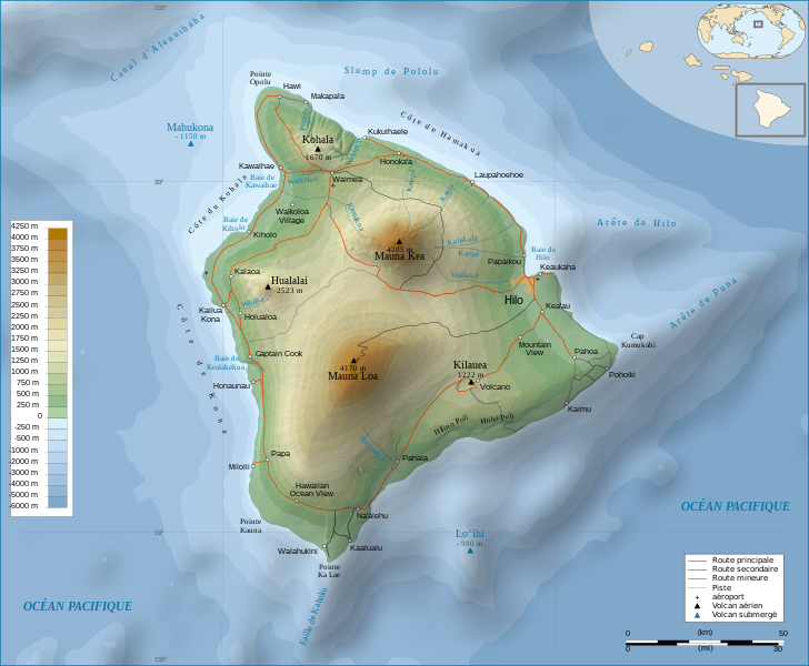
Hawaii Island topographic map
파일 설명[편집]
| 묘사 | |||
| 날짜 | |||
| 출처 |
Français : Travail personnel.
Sources :
Logiciels utilisés :
Autres données :
English: Personal work.
Sources:
Software used:
Other Details:
|
||
| 창작자 | |||
| 지리 참고 | 부적절한 경우에 숨기려면 warp_status = skip로 설정하세요. | ||
| 다른 버전 | |||
| 저작자표시 (required by the license) | © Sémhur / Wikimedia Commons / | ||
| Assessments |
|
||
| SVG | W3C-validity not checked.
|
||
| Graphic Lab |


| 카메라 위치 | | 이 지역의 다른 사진을 보기: OpenStreetMap |
|---|
라이선스[편집]
나는 아래 작품의 저작권자로서, 이 저작물을 다음과 같은 라이선스로 배포합니다:
| 카피레프트: 이 예술 작품은 프리 아트 라이선스의 조건에 따라 자유롭게 사용, 재배포, 수정할 수 있습니다.
라이선스 규약은 Copyleft Attitude 사이트, 혹은 다른 사이트에서 볼 수 있습니다. |
- 이용자는 다음의 권리를 갖습니다:
- 공유 및 이용 – 저작물의 복제, 배포, 전시, 공연 및 공중송신
- 재창작 – 저작물의 개작, 수정, 2차적저작물 창작
- 다음과 같은 조건을 따라야 합니다:
- 저작자표시 – 적절한 저작자 표시를 제공하고, 라이센스에 대한 링크를 제공하고, 변경사항이 있는지를 표시해야 합니다. 당신은 합리적인 방식으로 표시할 수 있지만, 어떤 방식으로든 사용권 허가자가 당신 또는 당신의 사용을 지지하는 방식으로 표시할 수 없습니다.
- 동일조건변경허락 – 만약 당신이 이 저작물을 리믹스 또는 변형하거나 이 저작물을 기반으로 제작하는 경우, 당신은 당신의 기여물을 원저작물과 동일하거나 호환 가능한 라이선스에 따라 배포하여야 합니다.
이 라이선스 중에서 목적에 맞는 것을 선택하여 사용할 수 있습니다.
파일 역사
날짜/시간 링크를 클릭하면 해당 시간의 파일을 볼 수 있습니다.
| 날짜/시간 | 섬네일 | 크기 | 사용자 | 설명 | |
|---|---|---|---|---|---|
| 현재 | 2009년 2월 16일 (월) 12:24 | | 3,110 × 2,563 (2.11 MB) | Sémhur (토론 | 기여) | Valid SVG |
| 2008년 5월 7일 (수) 17:31 |  | 3,110 × 2,563 (2.19 MB) | Sémhur (토론 | 기여) | Route coupée trop courte, je rallonge. | |
| 2008년 5월 2일 (금) 17:57 |  | 3,110 × 2,563 (2.18 MB) | Sémhur (토론 | 기여) | Suppression d'une partie d'une route détruite par une coulée de lave | |
| 2008년 5월 1일 (목) 10:37 |  | 3,110 × 2,563 (2.18 MB) | Sémhur (토론 | 기여) | New version, with vectorized shaded relief | |
| 2008년 4월 29일 (화) 18:35 |  | 3,110 × 2,563 (1,017 KB) | Sting (토론 | 기여) | Slight correction | |
| 2008년 4월 29일 (화) 18:11 |  | 3,110 × 2,563 (1,017 KB) | Sting (토론 | 기여) | Added legend | |
| 2008년 4월 22일 (화) 16:01 |  | 3,110 × 2,563 (1,012 KB) | Sémhur (토론 | 기여) | Espacement de lettres (oubli) | |
| 2008년 4월 19일 (토) 08:45 |  | 3,110 × 2,563 (1,011 KB) | Sémhur (토론 | 기여) | Correction de l'altitude du Mauna Loa et espacement de lettres | |
| 2008년 4월 17일 (목) 19:04 |  | 3,110 × 2,563 (995 KB) | Sémhur (토론 | 기여) | Correction d'un problème avec le relief | |
| 2008년 4월 17일 (목) 18:47 |  | 3,110 × 2,563 (996 KB) | Sémhur (토론 | 기여) | == Description == {{Information |Description= {{en| Topographic Map in french of the island of Hawaii.}} {{fr| Carte topographique de l'île de Hawaii.}} |Source=Travail personnel. {{clr}} Sources : * Fond de carte : |
이 파일을 덮어쓸 수 없습니다.
이 파일을 사용하는 문서
다음 문서 85개가 이 파일을 사용하고 있습니다:
- Wikimedia Conference Japan 2009/Commons写真展
- User:Aristeas/check
- User:John Cummings/gallerytest
- User:L.Kenzel/Category
- User:Miya/Introduction
- User:Miya/POTY/Diagrams2008
- User:Notafish/Votes 2008
- User:Sémhur
- User:Sémhur/Profile
- User talk:Sting/Archive 01
- Commons:Bu proje sayfasının diğer dil sürümleri
- Commons:Conhece os nossos ilustradores
- Commons:Conoce a nuestros ilustradores
- Commons:Descobreix els nostres il.lustradors
- Commons:Descobrètz nòstres illustrators
- Commons:Découvrez nos illustrateurs
- Commons:Featured picture candidates/Image:Hawaii Island topographic map-fr.svg
- Commons:Featured picture candidates/Log/May 2008
- Commons:Featured pictures/Non-photographic media/Computer-generated
- Commons:Featured pictures/Non-photographic media/Entertainment
- Commons:Featured pictures/Non-photographic media/Exteriors
- Commons:Featured pictures/Non-photographic media/Maps
- Commons:Featured pictures/Non-photographic media/Others
- Commons:Featured pictures/Non-photographic media/People
- Commons:Featured pictures/Non-photographic media/Printed
- Commons:Featured pictures/Non-photographic media/Religion
- Commons:Featured pictures/Non-photographic media/Science
- Commons:Meet our illustrators
- Commons:Meet our illustrators/People
- Commons:Picture of the Year/2008/Galleries/All
- Commons:Picture of the Year/2008/Galleries/Diagrams
- Commons:Picture of the Year/2008/Results/Round 1/Gallery/All
- Commons:Picture of the Year/2008/Results/Round 1/Gallery/Diagrams
- Commons:Picture of the Year 2008/File:Hawaii Island topographic map-fr.svg
- Commons:Potd/2010-02 (da)
- Commons:Potd/2010-02 (de)
- Commons:Potd/2010-02 (nl)
- Commons:Potd/2010-02 (pt)
- Commons:Poznaj naszych grafików
- Commons:Scopri i nostri illustratori
- Commons:Scummigghia ê nostri llustratura
- Commons:Unsere Illustratoren stellen sich vor
- Commons:Unseri Illustratore stelle sich vor
- Commons:Upoznajte naše ilustratore
- Commons:Çizerlerimizle tanışın
- Commons:Запознајте ги нашите илустратори
- Commons:Знайомтесь з нашими ілюстраторами
- Commons:Знакомьтесь с нашими иллюстраторами
- Commons:قابل رسامينا
- Commons:私達のイラストレータをご紹介します
- Commons:结识我们的插图师
- Commons:우리들의 삽화가를 만나보세요
- File:Hawaii Island topographic map-en.svg
- File:Hawaii Island topographic map-fr-vectorized.svg
- File:Hawaii saare kaart.png
- Template:Non-photographic FP galleries top
- Template:Other versions/Hawaii Island topographic map
- Template:Potd/2010-02
- Template:Potd/2010-02-12
- Template:Potd/2010-02-12 (bn)
- Template:Potd/2010-02-12 (bs)
- Template:Potd/2010-02-12 (ca)
- Template:Potd/2010-02-12 (cs)
- Template:Potd/2010-02-12 (da)
- Template:Potd/2010-02-12 (de)
- Template:Potd/2010-02-12 (en)
- Template:Potd/2010-02-12 (es)
- Template:Potd/2010-02-12 (fa)
- Template:Potd/2010-02-12 (fi)
- Template:Potd/2010-02-12 (fr)
- Template:Potd/2010-02-12 (hu)
- Template:Potd/2010-02-12 (it)
- Template:Potd/2010-02-12 (ko)
- Template:Potd/2010-02-12 (mk)
- Template:Potd/2010-02-12 (nl)
- Template:Potd/2010-02-12 (pam)
- Template:Potd/2010-02-12 (pl)
- Template:Potd/2010-02-12 (pt)
- Template:Potd/2010-02-12 (ro)
- Template:Potd/2010-02-12 (ru)
- Template:Potd/2010-02-12 (sv)
- Template:Potd/2010-02-12 (uk)
- Template:Potd/2010-02-12 (zh-hans)
- Template:Potd/2010-02-12 (zh-hant)
- Template:Potd/2010-02 (zh-hans)
이 파일을 사용하고 있는 모든 위키의 문서 목록
다음 위키에서 이 파일을 사용하고 있습니다:
- af.wikipedia.org에서 이 파일을 사용하고 있는 문서 목록
- ar.wikipedia.org에서 이 파일을 사용하고 있는 문서 목록
- bn.wikipedia.org에서 이 파일을 사용하고 있는 문서 목록
- crh.wikipedia.org에서 이 파일을 사용하고 있는 문서 목록
- cv.wikipedia.org에서 이 파일을 사용하고 있는 문서 목록
- en.wikipedia.org에서 이 파일을 사용하고 있는 문서 목록
- eo.wikipedia.org에서 이 파일을 사용하고 있는 문서 목록
- es.wikipedia.org에서 이 파일을 사용하고 있는 문서 목록
- eu.wikipedia.org에서 이 파일을 사용하고 있는 문서 목록
- fr.wikipedia.org에서 이 파일을 사용하고 있는 문서 목록
- Analogique
- Mauna Kea
- Mauna Loa
- Utilisateur:Sémhur
- Hawaï (île)
- Hualālai
- Discussion aide:Cartographie
- Discussion Wikipédia:Wikiconcours/mars 2008/Équipes/Équipe 5
- Projet:Impression/Wikigraphistes
- Utilisateur:Sémhur/Récompenses
- Wikipédia:Image du jour/juin 2010
- Wikipédia:Image du jour/16 juin 2010
- Kohala (volcan)
- Cap Kumukahi
- Phare du cap Kumukahi
- Discussion Wikipédia:Atelier graphique/Archive 10
- fr.wikinews.org에서 이 파일을 사용하고 있는 문서 목록
- hu.wikipedia.org에서 이 파일을 사용하고 있는 문서 목록
- id.wikipedia.org에서 이 파일을 사용하고 있는 문서 목록
- it.wikipedia.org에서 이 파일을 사용하고 있는 문서 목록
- ko.wikipedia.org에서 이 파일을 사용하고 있는 문서 목록
- krc.wikipedia.org에서 이 파일을 사용하고 있는 문서 목록
- lbe.wikipedia.org에서 이 파일을 사용하고 있는 문서 목록
- lv.wikipedia.org에서 이 파일을 사용하고 있는 문서 목록
- mg.wikipedia.org에서 이 파일을 사용하고 있는 문서 목록
- mk.wikipedia.org에서 이 파일을 사용하고 있는 문서 목록
- mt.wikipedia.org에서 이 파일을 사용하고 있는 문서 목록
이 파일의 더 많은 사용 내역을 봅니다.