File:Houston Ship Channel Barbours Cut.jpg
Bước tới điều hướng
Bước tới tìm kiếm

Kích thước hình xem trước: 800×534 điểm ảnh. Độ phân giải khác: 320×214 điểm ảnh | 640×427 điểm ảnh | 1.024×683 điểm ảnh | 1.500×1.001 điểm ảnh.
Tập tin gốc (1.500×1.001 điểm ảnh, kích thước tập tin: 693 kB, kiểu MIME: image/jpeg)
Chú thích
Chú thích
Ghi một dòng giải thích những gì có trong tập tin này
| Miêu tả |
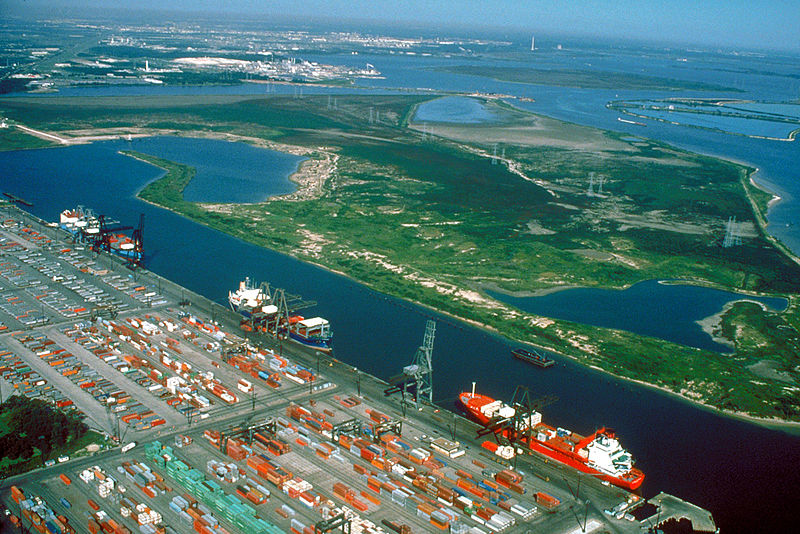
English: Aerial view of the Barbour's Cut area on the Houston Ship Channel in Houston, Texas, USA. This area is a large container terminal. This photograph appears to have been taken before the Fred Hartman Bridge was built, or when the bridge was under construction. In a present-day photograph, the bridge should be clearly visible at top right.
Coordinates: 29°40′54.98″N 94°59′54.37″W / 29.6819389°N 94.9984361°W |
|||
| Vị trí | Houston, Texas, USA | |||
| Ngày | Probably pre-1995 | |||
| Nguồn gốc |
U.S. Army Corps of Engineers Digital Visual Library Image page Image description page Digital Visual Library home page |
|||
| Tác giả | U.S. Army Corps of Engineers, photographer not specified or unknown | |||
| Giấy phép (Dùng lại tập tin) |
|
Lịch sử tập tin
Nhấn vào ngày/giờ để xem nội dung tập tin tại thời điểm đó.
| Ngày/Giờ | Hình xem trước | Kích cỡ | Thành viên | Miêu tả | |
|---|---|---|---|---|---|
| hiện tại | 01:22, ngày 10 tháng 5 năm 2007 | | 1.500×1.001 (693 kB) | DanMS (thảo luận | đóng góp) | {{Information | Description = {{en|Aerial view of the Barbour's Cut area on the Houston Ship Channel in Houston, Texas, USA. This area is a large container terminal. This photograph appears to have been taken before the Fred Hartman Bridge was built, o |
Bạn không được phép ghi đè tập tin này.
Trang sử dụng tập tin
4 trang sau sử dụng tập tin này:
Sử dụng tập tin toàn cục
Những wiki sau đang sử dụng tập tin này:
- Trang sử dụng tại ar.wikipedia.org
- Trang sử dụng tại bn.wikipedia.org
- Trang sử dụng tại de.wikipedia.org
- Trang sử dụng tại en.wikipedia.org
- Trang sử dụng tại es.wikipedia.org
- Trang sử dụng tại eu.wikipedia.org
- Trang sử dụng tại fi.wikipedia.org
- Trang sử dụng tại fr.wikipedia.org
- Trang sử dụng tại gu.wikipedia.org
- Trang sử dụng tại hu.wikipedia.org
- Trang sử dụng tại it.wikipedia.org
- Trang sử dụng tại ja.wikipedia.org
- Trang sử dụng tại lt.wikipedia.org
- Trang sử dụng tại ml.wikipedia.org
- Trang sử dụng tại nl.wikipedia.org
- Trang sử dụng tại no.wikipedia.org
- Trang sử dụng tại pl.wikipedia.org
- Trang sử dụng tại pnb.wikipedia.org
- Trang sử dụng tại pt.wikipedia.org
- Trang sử dụng tại ru.wikipedia.org
- Trang sử dụng tại te.wikipedia.org
- Trang sử dụng tại tr.wikipedia.org
- Trang sử dụng tại uk.wikipedia.org
- Trang sử dụng tại ur.wikipedia.org
- Trang sử dụng tại uz.wikipedia.org
- Trang sử dụng tại vi.wikipedia.org
- Trang sử dụng tại www.wikidata.org
Xem thêm các trang toàn cục sử dụng tập tin này.