File:Hurricane Paula 2010-10-12 1620Z.jpg
Jump to navigation
Jump to search
Size of this preview: 600 × 600 pixels. Other resolutions: 240 × 240 pixels | 480 × 480 pixels | 768 × 768 pixels | 1,024 × 1,024 pixels | 2,048 × 2,048 pixels | 5,600 × 5,600 pixels.
Original file (5,600 × 5,600 pixels, file size: 8.06 MB, MIME type: image/jpeg)
Captions
Captions
Add a one-line explanation of what this file represents
Summary[edit]
| Description |
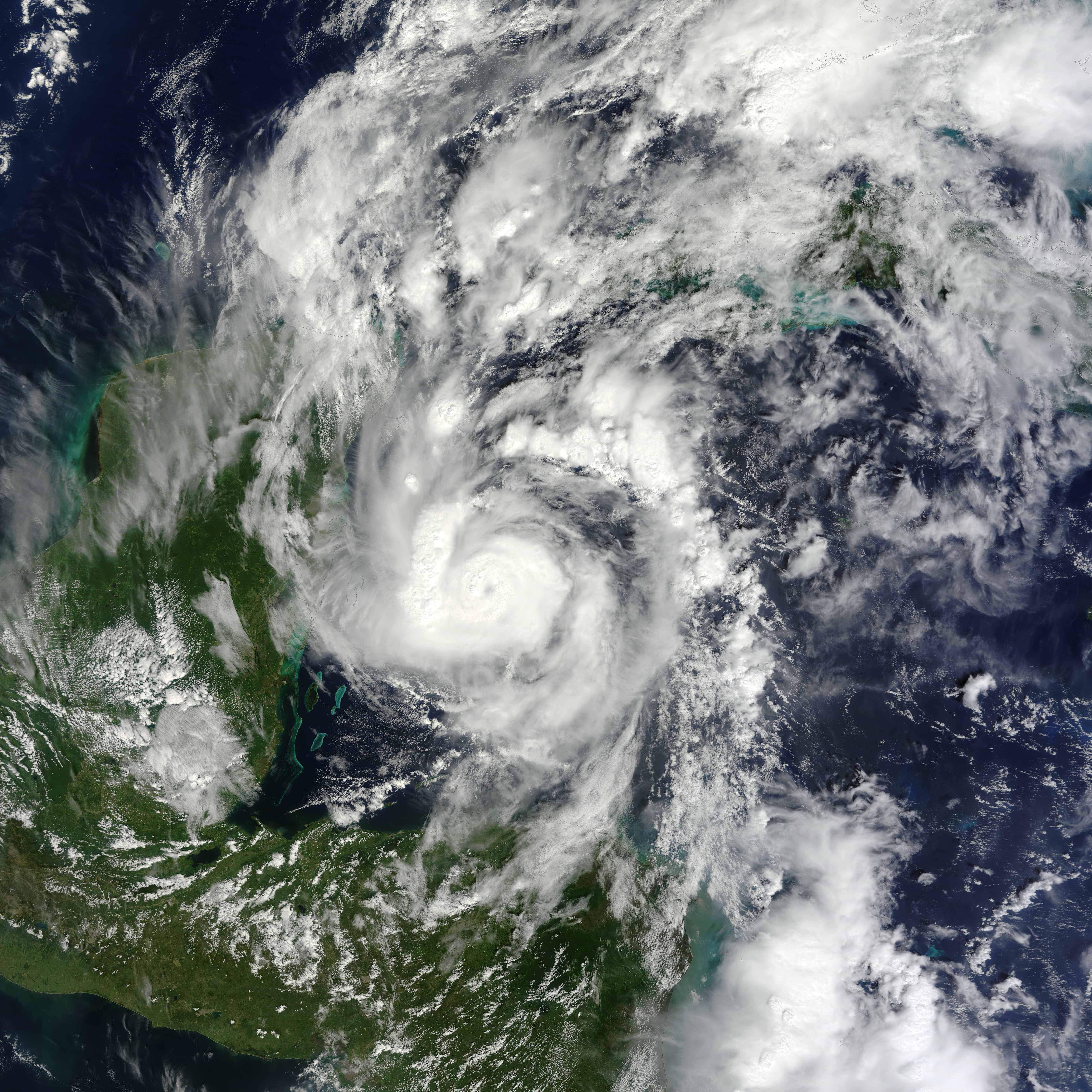
English: Small but powerful, Hurricane Paula packed winds of 100 miles (160 kilometers) per hour on October 12, 2010. At 12:45 p.m. Central Daylight Time (CDT), the U.S. National Hurricane Center (NHC) reported that Paula was a Category 2 hurricane, located roughly 140 miles (220 kilometers) south-southeast of Cozumel, Mexico, and was traveling slowly toward the north-northwest.
The Moderate Resolution Imaging Spectroradiometer (MODIS) on NASA’s Terra satellite captured this natural-color image of Hurricane Paula at 11:20 a.m. CDT (16:20 UTC) on October 12 while over the Caribbean Sea, just off the coasts of Mexico, Belize, and Honduras. Coiled around a distinct eye, the storm’s most intense clouds spanned roughly 200 kilometers (125 miles). By October 14, 2010, Paula had weakened to a tropical storm. At 10:00 a.m. CDT on October 14, the NHC reported that Paula had winds of 70 miles (110 kilometers) per hour. Though less intense than it had been two days earlier, Paula still posed hazards. A tropical storm warning was in effect for parts of Cuba, and a tropical storm watch was in effect for parts of the Florida Keys. The NHC warned of high winds and heavy rains—amounting to 10 inches (25 centimeters) in isolated areas. |
| Date | |
| Source | [1] |
| Author | NASA image by Jeff Schmaltz, MODIS Rapid Response Team at NASA GSFC. Caption by Michon Scott. |
Licensing[edit]
| This file is in the public domain in the United States because it was solely created by NASA. NASA copyright policy states that "NASA material is not protected by copyright unless noted". (See Template:PD-USGov, NASA copyright policy page or JPL Image Use Policy.) | ||
 |
Warnings:
|
File history
Click on a date/time to view the file as it appeared at that time.
| Date/Time | Thumbnail | Dimensions | User | Comment | |
|---|---|---|---|---|---|
| current | 03:33, 28 June 2013 | | 5,600 × 5,600 (8.06 MB) | HurricaneSpin (talk | contribs) | cropped |
| 22:56, 12 October 2010 |  | 5,600 × 7,200 (6.19 MB) | HurricaneSpin (talk | contribs) | {{Information |Description={{en|1=Hurricane Paula.}} |Source=[http://rapidfire.sci.gsfc.nasa.gov/gallery/?2010285-1012/Paula.A2010285.1620.2km.jpg] |Author=NASA/MODIS Rapid Response System |Date=2010-10-12 |Permission=See below |other_versions= }} [[Cate |
You cannot overwrite this file.
File usage on Commons
The following page uses this file:
File usage on other wikis
The following other wikis use this file:
- Usage on de.wikipedia.org
- Usage on en.wikipedia.org
- Usage on en.wikinews.org
- Usage on es.wikipedia.org
- Usage on fr.wikipedia.org
- Usage on ko.wikipedia.org
- Usage on nl.wikipedia.org
- Usage on pt.wikipedia.org
- Usage on simple.wikipedia.org
- Usage on www.wikidata.org
- Usage on zh.wikipedia.org