File:John-Tallis-1851-Tibet-Mongolia-and-Manchuria-33621.jpg

Tập tin gốc (4.030×3.102 điểm ảnh, kích thước tập tin: 12,64 MB, kiểu MIME: image/jpeg)
Chú thích
Chú thích
Miêu tả
[sửa]
| Miêu tả |
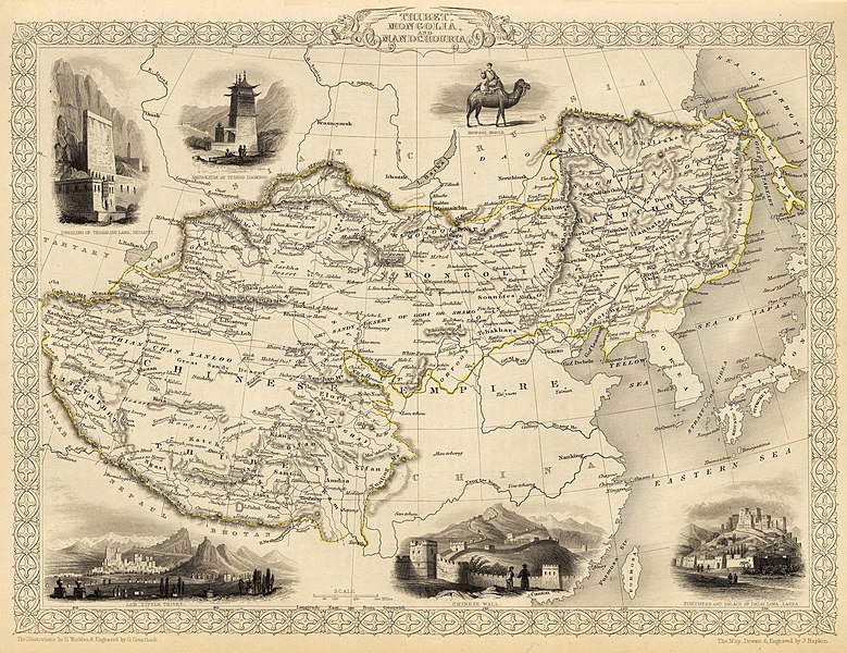
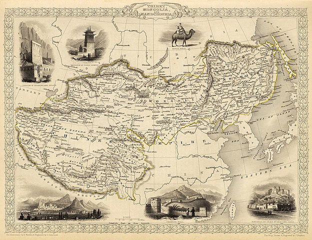
English: Map of the northern and western part of the Chinese Empire - "Thibet, Mongolia, and Mandchouria". The borders are shown as per the 1686 Treaty of Nerchinsk. (They were to be changed drastically in 1858-60, by treaty of Aigun and subsequent agreements). The main Russian center in Transbaikalia is still Nerchinsk, rather than Chita. The outline of Sakhalin Island is already shown fairly correctly, but the body of water separating it from the mainland is still labeled "Gulf of Tartary" (rather than '"Strait).
Français : Carte des parties Nord et Ouest de l'Empire chinois — « Thibet, Mongolie and Mandchourie ». Les frontières sont montrées telles qu'elles étaient définies par le Traité de Nerchinsk de 1686. (Elles allaient être grandement changées en 1858-1860 par le traité d'Aigun et les accords suivants). Le principal centre russe en Transbaïkalie est encore Nerchinsk, plutôt que Chita. Le contour de l'île Sakhaline est déjà décrit très correctement, mais l'étendue d'eau la séparant du continent est encore qualifiée de « golfe de Tartarie » (plutôt que « détroit »).
中文:中国皇国,北部和西部。 |
| Ngày | |
| Nguồn gốc | John Tallis' atlas of the world. Reproduced at http://www.davidrumsey.com/luna/servlet/detail/RUMSEY~8~1~821~60126:Thibet,-Mongolia,-and-Mandchouria-- (the last version uploaded is from there), http://www.jpmaps.co.uk/mapimages/originals/33621.jpg , and elsewhere |
| Tác giả | Martin, R.M.; Tallis, J. & F. The staff of John Tallis: The Illustrations by H. Winkles & Engraved by G. Greatbach. The Map Drawn & Engraved by J. Rapkin. |
| Phiên bản khác | Derivative works of this file: John-Tallis-1851-Tibet-Mongolia-and-Manchuria-NE.jpg |
Giấy phép
[sửa]
|
Tác phẩm này thuộc về phạm vi công cộng tại quốc gia gốc và các quốc gia và vùng lãnh thổ có thời hạn bản quyền là cuộc đời tác giả cộng thêm 70 trở xuống.
| |
| Tập tin này đã được đánh dấu là không bị hạn chế dưới luật bản quyền, kể cả tất cả những quyền liên quan và lần cận. | |
Lịch sử tập tin
Nhấn vào ngày/giờ để xem nội dung tập tin tại thời điểm đó.
| Ngày/Giờ | Hình xem trước | Kích cỡ | Thành viên | Miêu tả | |
|---|---|---|---|---|---|
| hiện tại | 20:51, ngày 28 tháng 2 năm 2016 | | 4.030×3.102 (12,64 MB) | Centpacrr (thảo luận | đóng góp) | Crop |
| 02:26, ngày 7 tháng 12 năm 2009 |  | 4.700×3.750 (4,07 MB) | Vmenkov (thảo luận | đóng góp) | better resolution, as available from http://www.davidrumsey.com/luna/servlet/detail/RUMSEY~8~1~821~60126:Thibet,-Mongolia,-and-Mandchouria-- | |
| 01:38, ngày 7 tháng 12 năm 2009 |  | 1.289×989 (386 kB) | Vmenkov (thảo luận | đóng góp) | {{Information |Description={{en|1=Map of the northern and western part of the Chinese Empire - "Thibet, Mongolia, and Mandchouria". The borders are shows as per the 1858 treaty of Aigun. The main Russian center in Transbaikalia is still Nerchinsk, rather |
Bạn không được phép ghi đè tập tin này.
Trang sử dụng tập tin
6 trang sau sử dụng tập tin này:
Sử dụng tập tin toàn cục
Những wiki sau đang sử dụng tập tin này:
- Trang sử dụng tại ar.wikipedia.org
- Trang sử dụng tại en.wikipedia.org
- Trang sử dụng tại fr.wikipedia.org
- Trang sử dụng tại hr.wikipedia.org
- Trang sử dụng tại mn.wikipedia.org
- Trang sử dụng tại sh.wikipedia.org
- Trang sử dụng tại vi.wikipedia.org
Đặc tính hình
- 1850s maps of China
- 19th-century maps of Tibet
- 19th-century maps of Mongolia
- 19th-century maps of Manchuria
- Old maps of the Qing Dynasty
- 19th-century maps of Tartary
- Maps by John Tallis
- Maps by Henry Winkles
- Robert Montgomery Martin
- Thangka wall
- Batang
- 1851 in Tibet
- History of Tashilhunpo
- Bactrian camels in art
- Potala Palace in art
- Old maps that include Leh
- 1850s maps of Korea
- Maps by John Rapkin
- Willow Palisade
- Great Wall in art