File:Karte Neuenburgersee.png
Jump to navigation
Jump to search

Size of this preview: 800 × 598 pixels. Other resolutions: 320 × 239 pixels | 640 × 479 pixels | 1,024 × 766 pixels | 1,280 × 957 pixels | 1,476 × 1,104 pixels.
Original file (1,476 × 1,104 pixels, file size: 403 KB, MIME type: image/png)
Captions
Captions
Add a one-line explanation of what this file represents
Summary[edit]

.png)
Licensing[edit]

|
Permission is granted to copy, distribute and/or modify this document under the terms of the GNU Free Documentation License, Version 1.2 or any later version published by the Free Software Foundation; with no Invariant Sections, no Front-Cover Texts, and no Back-Cover Texts. A copy of the license is included in the section entitled GNU Free Documentation License. |
| This file is licensed under the Creative Commons Attribution-Share Alike 3.0 Unported license. | ||
| ||
| This licensing tag was added to this file as part of the GFDL licensing update. |
File history
Click on a date/time to view the file as it appeared at that time.
| Date/Time | Thumbnail | Dimensions | User | Comment | |
|---|---|---|---|---|---|
| current | 12:12, 17 December 2021 | | 1,476 × 1,104 (403 KB) | Tschubby (talk | contribs) | {{Information |Description= |Source= |Date= |Author= |Permission= |other_versions= }} |
| 23:01, 7 January 2007 |  | 1,476 × 1,104 (404 KB) | Tschubby (talk | contribs) | ||
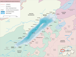
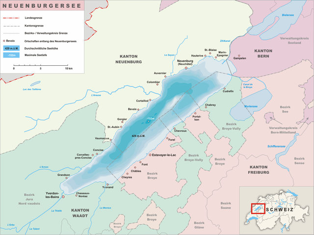
| 18:08, 22 June 2005 |  | 1,062 × 967 (297 KB) | Tschubby (talk | contribs) | *Description: Map of Neuenburgersee, Switzerland *Designer: Tschubby *Licence: {{GFDL}} Category:Maps of Swiss lakes |
You cannot overwrite this file.
File usage on Commons
The following 2 pages use this file:
File usage on other wikis
The following other wikis use this file:
- Usage on als.wikipedia.org
- Usage on ar.wikipedia.org
- Usage on arz.wikipedia.org
- Usage on ca.wikipedia.org
- Usage on ceb.wikipedia.org
- Usage on de.wikipedia.org
- Usage on en.wikipedia.org
- Usage on es.wikipedia.org
- Usage on eu.wikipedia.org
- Usage on fr.wikipedia.org
- Usage on hu.wikipedia.org
- Usage on hy.wikipedia.org
- Usage on it.wikipedia.org
- Usage on ja.wikipedia.org
- Usage on ko.wikipedia.org
- Usage on nl.wikipedia.org
- Usage on no.wikipedia.org
- Usage on pl.wikipedia.org
- Usage on pt.wikipedia.org
- Usage on rm.wikipedia.org
- Usage on ro.wikipedia.org
- Usage on scn.wikipedia.org
- Usage on simple.wikipedia.org
- Usage on sr.wikipedia.org
- Usage on sv.wikipedia.org
- Usage on uk.wikipedia.org
- Usage on www.wikidata.org
- Usage on zh.wikipedia.org