File:Karte Ogaden Haud Somali.gif
Jump to navigation
Jump to search
Size of this preview: 701 × 599 pixels. Other resolutions: 281 × 240 pixels | 561 × 480 pixels | 1,000 × 855 pixels.
Original file (1,000 × 855 pixels, file size: 183 KB, MIME type: image/gif)
Captions
Captions
Add a one-line explanation of what this file represents
Summary[edit]
| Description |
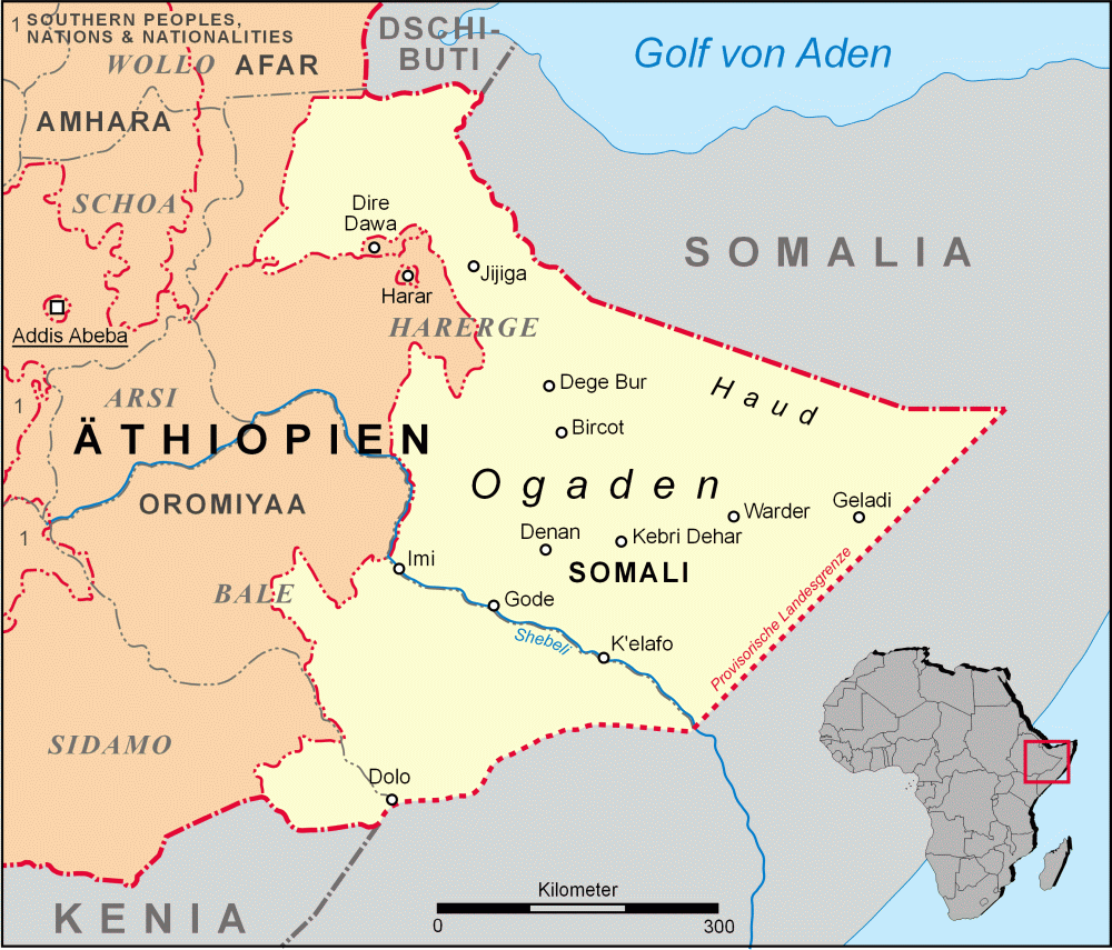
Deutsch: Karte Äthiopiens mit den Regionen Somali, Ogaden und Haud - Darstellung der traditionellen Provinzen bis 1995 (grau) und neuen Regionen (rot) nebst Grenzen
English: Map of Ethiopia (in German language) with the Somali region, Ogaden and the Haud – the Provinces prior to 1995 in grey, the contemporary regions in red |
| Date | |
| Source | Own work |
| Author | Lencer |
| Other versions | Derivative works of this file: Mappa Ogaden.svg |

|
This map has been made or improved in the German Kartenwerkstatt (Map Lab). You can propose maps to improve as well.
|
Licensing[edit]
I, the copyright holder of this work, hereby publish it under the following license:
This file is licensed under the Creative Commons Attribution-Share Alike 2.5 Generic license.
- You are free:
- to share – to copy, distribute and transmit the work
- to remix – to adapt the work
- Under the following conditions:
- attribution – You must give appropriate credit, provide a link to the license, and indicate if changes were made. You may do so in any reasonable manner, but not in any way that suggests the licensor endorses you or your use.
- share alike – If you remix, transform, or build upon the material, you must distribute your contributions under the same or compatible license as the original.
File history
Click on a date/time to view the file as it appeared at that time.
| Date/Time | Thumbnail | Dimensions | User | Comment | |
|---|---|---|---|---|---|
| current | 17:27, 22 June 2007 | | 1,000 × 855 (183 KB) | Lencer (talk | contribs) | |
| 12:20, 3 June 2007 |  | 1,000 × 852 (168 KB) | Lencer (talk | contribs) | ||
| 11:15, 3 June 2007 |  | 1,000 × 852 (179 KB) | Lencer (talk | contribs) | ||
| 19:58, 31 May 2007 |  | 1,000 × 852 (169 KB) | Lencer (talk | contribs) | ||
| 19:49, 31 May 2007 |  | 1,000 × 852 (162 KB) | Lencer (talk | contribs) | ||
| 20:01, 29 May 2007 |  | 1,000 × 852 (199 KB) | Lencer (talk | contribs) | ||
| 19:36, 28 May 2007 |  | 1,000 × 859 (159 KB) | Lencer (talk | contribs) | {{Information |Description= Karte Äthiopien mit Region Somali, Ogaden und Haud |Source="own work" |Date=Mai 2007 |Author=Lencer |other_versions= }} {{Kartenwerkstatt}} == Licensing == {{GFDL-GMT}} |
You cannot overwrite this file.
File usage on Commons
The following 3 pages use this file:
File usage on other wikis
The following other wikis use this file:
- Usage on ar.wikipedia.org
- Usage on arz.wikipedia.org
- Usage on ast.wikipedia.org
- Usage on az.wikipedia.org
- Usage on be.wikipedia.org
- Usage on ca.wikipedia.org
- Usage on cs.wikipedia.org
- Usage on de.wikipedia.org
- Usage on eo.wikipedia.org
- Usage on es.wikipedia.org
- Usage on fi.wikipedia.org
- Usage on fr.wikipedia.org
- Usage on gl.wikipedia.org
- Usage on he.wikipedia.org
- Usage on hu.wikipedia.org
- Usage on hy.wikipedia.org
- Usage on it.wikipedia.org
- Usage on it.wikivoyage.org
- Usage on ka.wikipedia.org
- Usage on pl.wikipedia.org
- Usage on pt.wikipedia.org
- Usage on ru.wikipedia.org
View more global usage of this file.