File:Kent UK relief location map.jpg
Jump to navigation
Jump to search
ഈ പ്രിവ്യൂവിന്റെ വലിപ്പം: 800 × 561 പിക്സലുകൾ. മറ്റ് റെസലൂഷനുകൾ: 320 × 224 പിക്സലുകൾ | 640 × 449 പിക്സലുകൾ | 1,024 × 718 പിക്സലുകൾ | 1,280 × 898 പിക്സലുകൾ | 1,999 × 1,402 പിക്സലുകൾ.
പൂർണ്ണ വലിപ്പം (1,999 × 1,402 പിക്സൽ, പ്രമാണത്തിന്റെ വലിപ്പം: 301 കെ.ബി., മൈം തരം: image/jpeg)
തലവാചകം
തലവാചകങ്ങൾ
ഈ പ്രമാണം എന്തിനെ പ്രതിനിധീകരിക്കുന്നുവെന്ന ഒറ്റവരി വിശദീകരണം ചേർക്കുക
| വിവരണം |
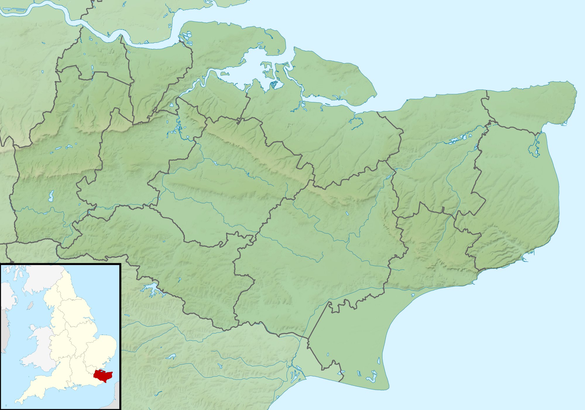
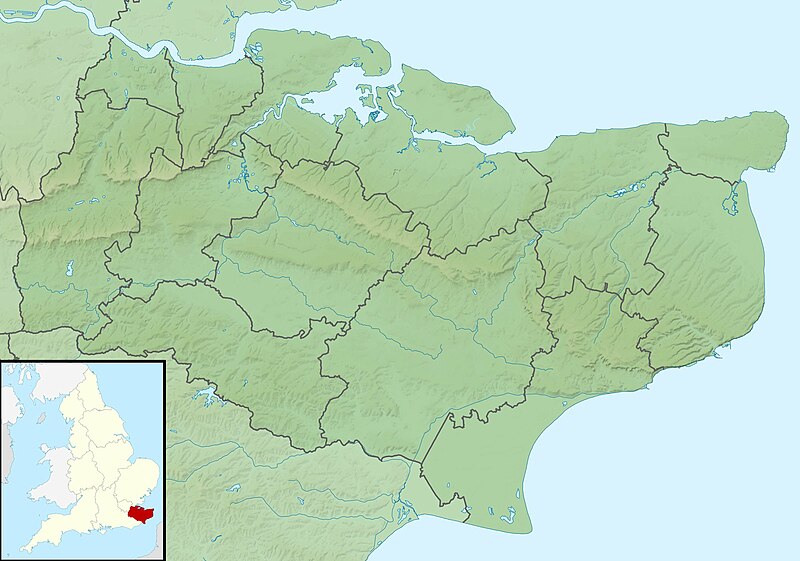
Relief map of Kent, UK. Equirectangular map projection on WGS 84 datum, with N/S stretched 160% Geographic limits:
|
| തീയതി | |
| സ്രോതസ്സ് |
|
| സ്രഷ്ടാവ് | Nilfanion, created using Ordnance Survey data |
| അനുമതി (ഈ പ്രമാണത്തിന്റെ പുനരുപയോഗം) |
ഈ പ്രമാണത്തിന് അനുമതി നൽകപ്പെട്ടിരിക്കുന്നത് ക്രിയേറ്റീവ് കോമൺസ് ആട്രിബ്യൂഷൻ-ഷെയർ എലൈക് 3.0 അൺപോർട്ടഡ് അനുവാദപത്ര പ്രകാരമാണ്. കടപ്പാട്: Contains Ordnance Survey data © Crown copyright and database right
|
| മറ്റു പതിപ്പുകൾ | File:Kent UK district map (blank).svg - Blank map |
.svg)
പ്രമാണ നാൾവഴി
ഏതെങ്കിലും തീയതി/സമയ കണ്ണിയിൽ ഞെക്കിയാൽ പ്രസ്തുതസമയത്ത് ഈ പ്രമാണം എങ്ങനെയായിരുന്നു എന്നു കാണാം.
| തീയതി/സമയം | ലഘുചിത്രം | അളവുകൾ | ഉപയോക്താവ് | അഭിപ്രായം | |
|---|---|---|---|---|---|
| നിലവിലുള്ളത് | 01:42, 29 നവംബർ 2011 | | 1,999 × 1,402 (301 കെ.ബി.) | Nilfanion (സംവാദം | സംഭാവനകൾ) | {{Information |Description=Relief map of Kent, UK. Equirectangular map projection on WGS 84 datum, with N/S stretched 160% Geographic limits: *West: 0.01E *East: 1.47E *North: 51.52N *South: 50.88N |Source=[[w:Ordnance Survey|Ordnance Survey] |
ഈ പ്രമാണത്തിനു മുകളിൽ മറ്റൊരു പ്രമാണം ചേർക്കാൻ താങ്കൾക്ക് കഴിയില്ല.
പ്രമാണത്തിന്റെ ഉപയോഗം
ഈ പ്രമാണം വിക്കിയിലെ താളുകളിലൊന്നിലും ഉപയോഗിക്കുന്നില്ല.
പ്രമാണത്തിന്റെ ആഗോള ഉപയോഗം
താഴെ കൊടുത്തിരിക്കുന്ന മറ്റ് വിക്കികൾ ഈ പ്രമാണം ഉപയോഗിക്കുന്നു:
- ar.wikipedia.org സംരംഭത്തിലെ ഉപയോഗം
- bg.wikipedia.org സംരംഭത്തിലെ ഉപയോഗം
- ceb.wikipedia.org സംരംഭത്തിലെ ഉപയോഗം
- el.wikipedia.org സംരംഭത്തിലെ ഉപയോഗം
- en.wikipedia.org സംരംഭത്തിലെ ഉപയോഗം
- John Dixwell
- Ightham Mote
- Chartwell
- Bewl Water
- Volvo World Match Play Championship
- Royal Cinque Ports Golf Club
- Michael Livesey
- Medway Gap
- London Seniors Masters
- Walmer Lifeboat Station
- Betsom's Hill
- Cliffe Fort
- The Grange, Ramsgate
- 1993 Open Championship
- Long Barn
- Ramsgate Lifeboat Station
- Nathaniel Rich (soldier)
- Capel Manor House
- User:Jokulhlaup/draftarticle21
- Broome Park
- St Augustine's Abbey
- Margate Lifeboat Station
- Whitstable Lifeboat Station
- Sheerness Lifeboat Station
- Dover Lifeboat Station
- SS Maloja
- Poundsbridge Manor
- Dover lorry deaths
- Thanet & District Reform Synagogue
- Module:Location map/data/United Kingdom Kent
- Module:Location map/data/Kent
- Module:Location map/data/United Kingdom Kent/doc
ഈ പ്രമാണത്തിന്റെ കൂടുതൽ ആഗോള ഉപയോഗം കാണുക.