File:Kgeorge map.png
Jump to navigation
Jump to search
No higher resolution available.
Kgeorge_map.png (660 × 402 pixels, file size: 296 KB, MIME type: image/png)
Captions
Captions
Add a one-line explanation of what this file represents
Summary[edit]
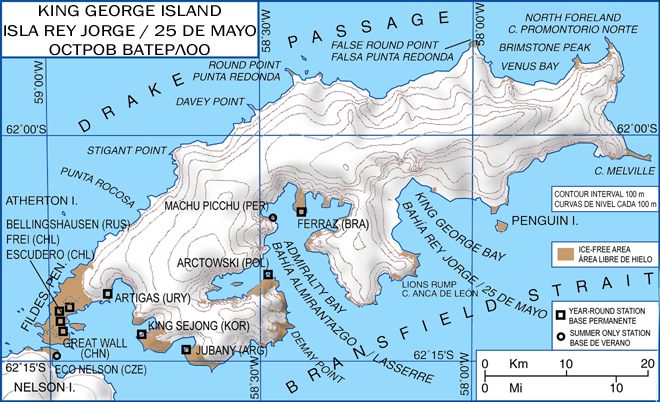
| Description | King George Island map. Detailed. Relief. Research Stations. | |||||||||||||||||||||||
| Date | ||||||||||||||||||||||||
| Source | http://krapp.org/rupert/blog-uploads/Kgeorge_map.png | |||||||||||||||||||||||
| Author |
|
|||||||||||||||||||||||
| Permission (Reusing this file) |
GNU free licence | |||||||||||||||||||||||
| Other versions |
Derivative works of this file: |
|||||||||||||||||||||||
,_by_Giovanni_Fattori.jpg)
.svg)
.svg)
Licensing[edit]

|
Permission is granted to copy, distribute and/or modify this document under the terms of the GNU Free Documentation License, Version 1.2 or any later version published by the Free Software Foundation; with no Invariant Sections, no Front-Cover Texts, and no Back-Cover Texts. A copy of the license is included in the section entitled GNU Free Documentation License. |
| This file is licensed under the Creative Commons Attribution-Share Alike 3.0 Unported license. | ||
| ||
| This licensing tag was added to this file as part of the GFDL licensing update. |
File history
Click on a date/time to view the file as it appeared at that time.
| Date/Time | Thumbnail | Dimensions | User | Comment | |
|---|---|---|---|---|---|
| current | 13:13, 22 January 2008 | | 660 × 402 (296 KB) | Wadim (talk | contribs) | {{Information| |Description= King George Island map. Detailed. Relief. Research Stations. Modificado 22.01.2008: Quito la firma, añado denominación historica en ruso. |Source= |Date= 06-May-2006 |Author= Giovanni Fattori |Permission= GNU free licence |o |
| 17:51, 6 May 2006 |  | 660 × 402 (300 KB) | Gi (talk | contribs) | {{Information| |Description= King George Island map. Detailed. Relief. Research Stations. |Source= |Date= 06-May-2006 |Author= Giovanni Fattori |Permission= GNU free licence |other_versions= }} |
You cannot overwrite this file.
File usage on Commons
The following 3 pages use this file:
File usage on other wikis
The following other wikis use this file:
- Usage on ar.wikipedia.org
- Usage on az.wikipedia.org
- Usage on bg.wikipedia.org
- Usage on ca.wikipedia.org
- Usage on ceb.wikipedia.org
- Usage on de.wikipedia.org
- Usage on en.wikipedia.org
- Usage on eo.wikipedia.org
- Usage on es.wikipedia.org
- Usage on fi.wikipedia.org
- Usage on fr.wikipedia.org
- Usage on gl.wikipedia.org
- Usage on hu.wikipedia.org
- Usage on it.wikipedia.org
- Stazione antartica polacca Henryk Arctowski
- Stazione Bellingshausen
- Stazione antartica comandante Ferraz
- Base professor Julio Escudero
- Stazione grande muraglia
- Stazione Carlini
- Base scientifica Sejong
- Laboratorio Dallmann
- Base presidente Eduardo Frei Montalva
- Isola di re Giorgio
- Stazione Pieter J. Lenie
- Isola Penguin (Shetland Meridionali)
- Base Machu Picchu
- Usage on ja.wikipedia.org
- Usage on ko.wikipedia.org
- Usage on lt.wikipedia.org
- Usage on lv.wikipedia.org
- Usage on mk.wikipedia.org
- Usage on nl.wikipedia.org
- Usage on no.wikipedia.org
- Usage on pl.wikipedia.org
- Usage on pt.wikipedia.org
- Usage on ru.wikipedia.org
- Usage on sv.wikipedia.org
View more global usage of this file.