File:Kosovo02.png
Jump to navigation
Jump to search
Size of this preview: 546 × 599 pixels. Other resolutions: 219 × 240 pixels | 437 × 480 pixels | 770 × 845 pixels.
Original file (770 × 845 pixels, file size: 76 KB, MIME type: image/png)
Captions
Captions
Add a one-line explanation of what this file represents
Summary
[edit]
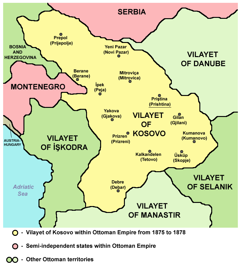
Vilayet of Kosovo within Ottoman Empire from 1875 to 1878.
Source and licence
[edit]

|
This map has been uploaded by Electionworld from en.wikipedia.org to enable the |
| This work has been released into the public domain by its author, PANONIAN. This applies worldwide. In some countries this may not be legally possible; if so: |
References
[edit]
Main reference:
- Created according to historical map from this book: Petrit Imami, Srbi i Albanci kroz vekove, Beograd, 2000.
Secondary references with similar maps:
File history
Click on a date/time to view the file as it appeared at that time.
| Date/Time | Thumbnail | Dimensions | User | Comment | |
|---|---|---|---|---|---|
| current | 12:46, 11 September 2012 | | 770 × 845 (76 KB) | PANONIAN (talk | contribs) | cosmetic changes |
| 07:16, 6 April 2011 |  | 692 × 808 (62 KB) | PANONIAN (talk | contribs) | Reverted to version as of 08:40, 5 April 2011 - trying to solve thumbnail problem | |
| 07:15, 6 April 2011 |  | 692 × 808 (64 KB) | PANONIAN (talk | contribs) | Reverted to version as of 19:07, 2 June 2009 - trying to solve thumbnail problem | |
| 08:40, 5 April 2011 |  | 692 × 808 (62 KB) | PANONIAN (talk | contribs) | aesthetical improvement | |
| 19:07, 2 June 2009 |  | 692 × 808 (64 KB) | PANONIAN (talk | contribs) | ||
| 16:30, 2 June 2009 |  | 692 × 808 (65 KB) | PANONIAN (talk | contribs) | ||
| 23:37, 29 January 2008 |  | 626 × 614 (200 KB) | Mahahahaneapneap (talk | contribs) | pngcrushed | |
| 23:32, 21 December 2006 |  | 626 × 614 (221 KB) | Electionworld (talk | contribs) | {{ew|en|PANONIAN}} {{PD-user|PANONIAN}} Category:Maps of Kosovo |
You cannot overwrite this file.
File usage on Commons
The following page uses this file:
File usage on other wikis
The following other wikis use this file:
- Usage on af.wikipedia.org
- Usage on az.wikipedia.org
- Usage on be.wikipedia.org
- Usage on bg.wikipedia.org
- Usage on bn.wikipedia.org
- Usage on br.wikipedia.org
- Usage on bs.wikipedia.org
- Usage on ca.wikipedia.org
- Usage on ckb.wikipedia.org
- Usage on cs.wikipedia.org
- Usage on da.wikipedia.org
- Usage on de.wikipedia.org
- Usage on el.wikipedia.org
- Usage on en.wikipedia.org
- Usage on es.wikipedia.org
- Usage on et.wikipedia.org
- Usage on fi.wikipedia.org
- Usage on fr.wikipedia.org
- Usage on fy.wikipedia.org
- Usage on gl.wikipedia.org
- Usage on he.wikipedia.org
- Usage on hr.wikipedia.org
- Usage on ht.wikipedia.org
- Usage on hu.wikipedia.org
- Usage on hy.wikipedia.org
- Usage on io.wikipedia.org
- Usage on it.wikipedia.org
- Usage on ja.wikipedia.org
- Usage on lt.wikipedia.org
- Usage on lv.wikipedia.org
View more global usage of this file.
Categories:
- Maps of the history of Kosovo under Ottoman Empire
- Maps of the history of North Macedonia under Ottoman Empire
- Maps of the Ottoman period in the history of Serbia
- Maps of the history of Montenegro under Ottoman and Venetian rule
- Maps of vilayets of the Ottoman Empire
- Maps of the Ottoman Empire in the 19th century
- Vilayet of Kosovo