File:Landgebruik en topografie voorbeeld.png

Original file (800 × 813 pixels, file size: 1.5 MB, MIME type: image/png)
Captions
Captions
| DescriptionLandgebruik en topografie voorbeeld.png |
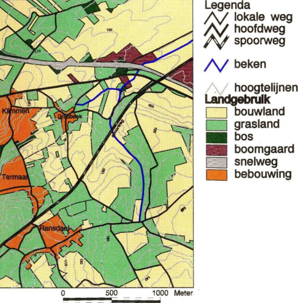
Nederlands: Landgebruik voorbeeld tbv GIS-studie erosiegevoeligheidskartering in Löss-gebieden. Vraag: - Mail van T.Nijeholt aan B. van der Grift dd 3-10-2007: Sent: woensdag 3 oktober 2007 21:43 To: Grift, B. (Bas) van der Subject: Erosiegevoeligheidskartering uit 1996 / contact - Beste Bas, [...] Ik ben op dit moment bezig om op Wikibooks een handboek geeo-visualisatie te schrijven, [...] zie evt. http://nl.wikibooks.org/wiki/Geo-visualisatie). Daarvoor heb ik veel illustraties nodig.. De meeste maak ik zelf, omdat het in de licentie van de wikigemeenschap streng verboden is - in tegenstelling tot wat de praktijk is bij vele andere sites! - om andermans plaatjes gewoon te kopiëren, al of niet met bron vermelding. [...] Nu wil ik als voorbeeld de erosiegevoeligheidskartering, dat wil zeggen de plaatjes die jij en ik hebben gemaakt in wikibooks opnemen. Is dit accoord? Laat even weten, BVD. Vragen en opmerkingen zijn uiteraard welkom. M.vr.groet, Tjeerd Nijeholt, - Reactie: - Mail van B. van der Grift aan T.Nijeholt dd 4-10-2007: - Ha Tjeerd, [...] Uiteraard mag je de plaatjes van ons practicum gebruiken. [...] Groeten Bas - Bas van der Grift, TNO Bouw & Ondergrond / Built Environment & Geosciences Geological Survey of the Netherlands |
||
| Date | dec-1996 / 3-10-2007 | ||
| Source | Eigen media | ||
| Author | T.Nijeholt en B. van der Grift | ||
| Permission (Reusing this file) |
|
Licensing[edit]
- You are free:
- to share – to copy, distribute and transmit the work
- to remix – to adapt the work
- Under the following conditions:
- attribution – You must give appropriate credit, provide a link to the license, and indicate if changes were made. You may do so in any reasonable manner, but not in any way that suggests the licensor endorses you or your use.
- share alike – If you remix, transform, or build upon the material, you must distribute your contributions under the same or compatible license as the original.

|
Permission is granted to copy, distribute and/or modify this document under the terms of the GNU Free Documentation License, Version 1.2 or any later version published by the Free Software Foundation; with no Invariant Sections, no Front-Cover Texts, and no Back-Cover Texts. A copy of the license is included in the section entitled GNU Free Documentation License.http://www.gnu.org/copyleft/fdl.htmlGFDLGNU Free Documentation Licensetruetrue |
Original upload log[edit]
- 2007-10-03 19:25 Nijeholt 800×813× (1949609 bytes) {{Information |Description=Landgebruik voorbeeld tbv GIS-studie erosiegevoeligheidskartering in Löss-gebieden. |Source=Eigen media |Date=dec-1996 / 3-10-2007 |Author=T.Nijeholt |Permission= |other_versions= }}
File history
Click on a date/time to view the file as it appeared at that time.
| Date/Time | Thumbnail | Dimensions | User | Comment | |
|---|---|---|---|---|---|
| current | 18:45, 25 August 2009 |  | 800 × 813 (1.5 MB) | Platonides (talk | contribs) | Strip office document. |
| 18:38, 25 August 2009 |  | 800 × 813 (1.86 MB) | BotMultichill (talk | contribs) | {{BotMoveToCommons|nl.wikibooks|year={{subst:CURRENTYEAR}}|month={{subst:CURRENTMONTHNAME}}|day={{subst:CURRENTDAY}}}} {{Information |Description={{nl|Landgebruik voorbeeld tbv GIS-studie erosiegevoeligheidskartering in Löss-gebieden.<br/> Vraag: - Mai |
You cannot overwrite this file.
File usage on Commons
There are no pages that use this file.
File usage on other wikis
The following other wikis use this file:
- Usage on nl.wikibooks.org