File:Leizhou peninsula.jpg
Từ Wikimedia Commons, kho lưu trữ phương tiện nội dung mở
Bước tới điều hướng
Bước tới tìm kiếm

Kích thước hình xem trước: 629×600 điểm ảnh. Độ phân giải khác: 252×240 điểm ảnh | 503×480 điểm ảnh | 806×768 điểm ảnh | 1.074×1.024 điểm ảnh | 1.397×1.332 điểm ảnh.
Tập tin gốc (1.397×1.332 điểm ảnh, kích thước tập tin: 517 kB, kiểu MIME: image/jpeg)
Thông tin tập tin
Dữ liệu có cấu trúc
Chú thích
Chú thích
Ghi một dòng giải thích những gì có trong tập tin này
Miêu tả
[sửa]| Miêu tảLeizhou peninsula.jpg |
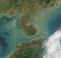
Satelite image of Leizhou Peninsula, and south across Qiongzhou Strait to Hainan island — in the Provinces of Guangdong (peninsula) and Hainan (island), in Southeast China. 中文(繁體):雷州半島衛星圖像
中文(简体):雷州半岛卫星图像 |
| Ngày | |
| Nguồn gốc | NASA Visible Earth. cropped from http://visibleearth.nasa.gov/view_rec.php?id=2301 |
| Tác giả | NASA |
Giấy phép
[sửa]| Public domainPublic domainfalsefalse |
| This file is in the public domain in the United States because it was solely created by NASA. NASA copyright policy states that "NASA material is not protected by copyright unless noted". (See Template:PD-USGov, NASA copyright policy page or JPL Image Use Policy.) |  | |
 |
Warnings:
|
Lịch sử tập tin
Nhấn vào ngày/giờ để xem nội dung tập tin tại thời điểm đó.
| Ngày/Giờ | Hình xem trước | Kích cỡ | Thành viên | Miêu tả | |
|---|---|---|---|---|---|
| hiện tại | 11:06, ngày 25 tháng 8 năm 2007 |  | 1.397×1.332 (517 kB) | ChongDae (thảo luận | đóng góp) | {{Information |Description=Satelite image of en:Leizhou Peninsula. |Source=NASA Visible Earth. cropped from http://visibleearth.nasa.gov/view_rec.php?id=2301 |Date=2001-11-16 |Author=NASA, ~~~ |Permission= |other_versions= }} [[Category:Satellite p |
Bạn không được phép ghi đè tập tin này.
Trang sử dụng tập tin
23 trang sau sử dụng tập tin này:
- User:Chinggis6/Favorites
- Category:2020 in Guangdong
- Category:Airports in Guangdong
- Category:Bridges in Guangdong
- Category:Buddhism in Guangdong
- Category:Churches in Guangdong
- Category:Confucian temples in Guangdong
- Category:Deaths in Guangdong
- Category:Education in Guangdong
- Category:Flora of Guangdong
- Category:Guangdong
- Category:Hospitals in Guangdong
- Category:Islands of Guangdong
- Category:Leizhou Peninsula
- Category:Maps of Guangdong
- Category:Mosques in Guangdong
- Category:Mountains of Guangdong
- Category:Power plants in Guangdong
- Category:Rail transport in Guangdong
- Category:Roads in Guangdong
- Category:Sports in Guangdong
- Category:Views of Guangdong
- Category:Visitor attractions in Guangdong
Sử dụng tập tin toàn cục
Những wiki sau đang sử dụng tập tin này:
- Trang sử dụng tại ar.wikipedia.org
- Trang sử dụng tại arz.wikipedia.org
- Trang sử dụng tại ast.wikipedia.org
- Trang sử dụng tại az.wikipedia.org
- Trang sử dụng tại be.wikipedia.org
- Trang sử dụng tại bg.wikipedia.org
- Trang sử dụng tại bn.wikipedia.org
- Trang sử dụng tại ca.wikipedia.org
- Trang sử dụng tại ce.wikipedia.org
- Trang sử dụng tại cs.wikipedia.org
- Trang sử dụng tại cy.wikipedia.org
- Trang sử dụng tại da.wikipedia.org
- Trang sử dụng tại de.wikipedia.org
- Trang sử dụng tại de.wikivoyage.org
- Trang sử dụng tại el.wikipedia.org
- Trang sử dụng tại en.wikipedia.org
- Trang sử dụng tại es.wikipedia.org
- Trang sử dụng tại eu.wikipedia.org
- Trang sử dụng tại fi.wikipedia.org
- Trang sử dụng tại fr.wikipedia.org
- Trang sử dụng tại fr.wikivoyage.org
- Trang sử dụng tại fy.wikipedia.org
- Trang sử dụng tại ga.wikipedia.org
- Trang sử dụng tại gl.wikipedia.org
- Trang sử dụng tại he.wikipedia.org
- Trang sử dụng tại hy.wikipedia.org
- Trang sử dụng tại ia.wikipedia.org
- Trang sử dụng tại id.wikipedia.org
- Trang sử dụng tại it.wikipedia.org
- Trang sử dụng tại ja.wikipedia.org
- Trang sử dụng tại ka.wikipedia.org
- Trang sử dụng tại ko.wikipedia.org
- Trang sử dụng tại ku.wikipedia.org
- Trang sử dụng tại lmo.wikipedia.org
- Trang sử dụng tại lt.wikipedia.org
Xem thêm các trang toàn cục sử dụng tập tin này.
Đặc tính hình
Tập tin này chứa thông tin bổ sung, có thể được thêm từ máy ảnh kỹ thuật số hoặc máy quét được sử dụng để tạo hoặc số hóa tập tin.
Nếu tập tin đã được sửa đổi so với trạng thái ban đầu, một số chi tiết có thể không phản ánh đầy đủ tập tin đã sửa đổi.
| Phân giải theo chiều ngang | 1 điểm/inch |
|---|---|
| Phân giải theo chiều cao | 1 điểm/inch |
| Phần mềm sử dụng | Paint.NET v3.10 |