File:Lignes de métro de Rennes.svg
Jump to navigation
Jump to search

Size of this PNG preview of this SVG file: 800 × 579 pixels. Other resolutions: 320 × 232 pixels | 640 × 463 pixels | 1,024 × 741 pixels | 1,280 × 926 pixels | 2,560 × 1,853 pixels | 807 × 584 pixels.
Original file (SVG file, nominally 807 × 584 pixels, file size: 776 KB)
Captions
Captions
Add a one-line explanation of what this file represents
Summary[edit]
| Description |
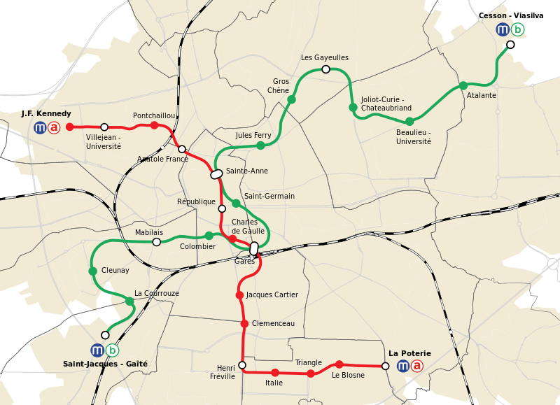
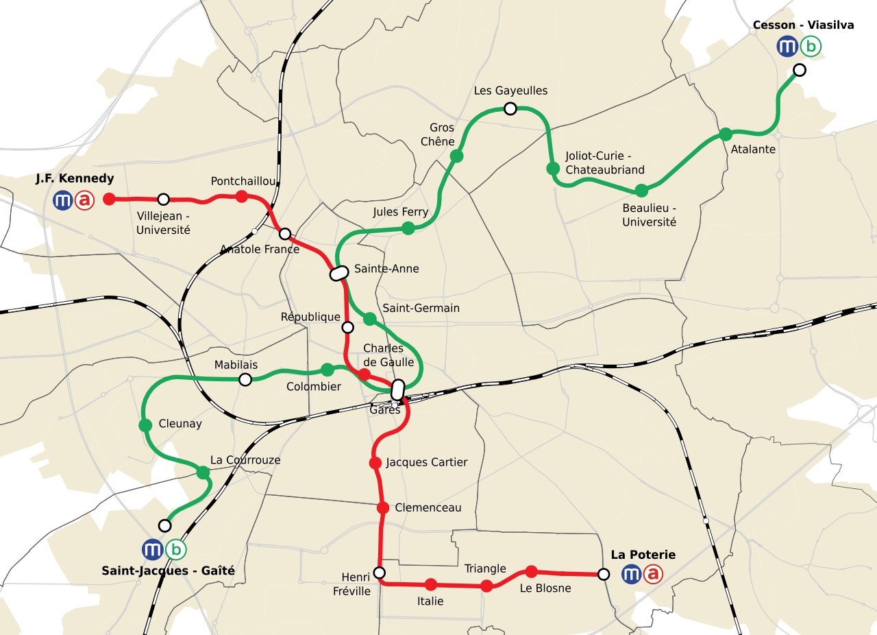
Français : Carte des lignes ferroviaires de Rennes (métro + voies SNCF). Projection utilisée : WGS 84 / Pseudo Mercator. |
| Date | |
| Source |
Own work from : |
| Author | Flappiefh |
Licensing[edit]
I, the copyright holder of this work, hereby publish it under the following license:
This file is licensed under the Creative Commons Attribution-Share Alike 4.0 International license.
- You are free:
- to share – to copy, distribute and transmit the work
- to remix – to adapt the work
- Under the following conditions:
- attribution – You must give appropriate credit, provide a link to the license, and indicate if changes were made. You may do so in any reasonable manner, but not in any way that suggests the licensor endorses you or your use.
- share alike – If you remix, transform, or build upon the material, you must distribute your contributions under the same or compatible license as the original.
File history
Click on a date/time to view the file as it appeared at that time.
| Date/Time | Thumbnail | Dimensions | User | Comment | |
|---|---|---|---|---|---|
| current | 16:24, 27 March 2023 | | 807 × 584 (776 KB) | Lyon-St-Clair (talk | contribs) | test de correction |
| 09:11, 16 April 2022 |  | 807 × 584 (776 KB) | Lyon-St-Clair (talk | contribs) | Trait de la ligne B : Suppression des pointillés en vue de la mise en service | |
| 17:11, 26 December 2020 |  | 807 × 584 (805 KB) | Lyon-St-Clair (talk | contribs) | Du texte en gras était repassé en normal... | |
| 17:09, 26 December 2020 |  | 807 × 584 (805 KB) | Lyon-St-Clair (talk | contribs) | technical updates | |
| 17:08, 26 December 2020 |  | 807 × 584 (776 KB) | Lyon-St-Clair (talk | contribs) | updates | |
| 14:08, 19 May 2019 |  | 807 × 584 (804 KB) | PanierAvide (talk | contribs) | Couleur de la ligne b selon signalétique des stations | |
| 22:53, 15 November 2017 |  | 807 × 584 (810 KB) | Flappiefh (talk | contribs) | Ajout d'un saut de ligne pour Joliot-Curie - Chateaubriand. | |
| 22:49, 15 November 2017 |  | 807 × 584 (702 KB) | Flappiefh (talk | contribs) | Nouveau nom de station : Joliot-Curie - Chateaubriand. | |
| 17:11, 26 November 2016 |  | 807 × 584 (809 KB) | Flappiefh (talk | contribs) | User created page with UploadWizard |
You cannot overwrite this file.
File usage on Commons
The following 25 pages use this file:
- Rennes Metro
- User:Chumwa/OgreBot/München/2016 November 21-30
- User:Chumwa/OgreBot/München/2017 November 11-20
- User:Chumwa/OgreBot/München/2019 May 11-20
- User:Chumwa/OgreBot/Potential transport maps/2016 November 21-30
- User:Chumwa/OgreBot/Potential transport maps/2017 November 11-20
- User:Chumwa/OgreBot/Potential transport maps/2019 May 11-20
- User:Chumwa/OgreBot/Public transport information/2016 November 21-30
- User:Chumwa/OgreBot/Public transport information/2017 November 11-20
- User:Chumwa/OgreBot/Public transport information/2019 May 11-20
- User:Chumwa/OgreBot/Public transport information/2020 December 21-31
- User:Chumwa/OgreBot/Public transport information/2022 April 11-20
- User:Chumwa/OgreBot/Public transport information/2023 March 21-31
- User:Chumwa/OgreBot/Transport Maps/2016 November 21-30
- User:Chumwa/OgreBot/Transport Maps/2017 November 11-20
- User:Chumwa/OgreBot/Transport Maps/2019 May 11-20
- User:Chumwa/OgreBot/Transport Maps/2020 December 21-31
- User:Chumwa/OgreBot/Transport Maps/2022 April 11-20
- User:Chumwa/OgreBot/Transport Maps/2023 March 21-31
- User:Chumwa/OgreBot/Travel and communication maps/2016 November 21-30
- User:Chumwa/OgreBot/Travel and communication maps/2017 November 11-20
- User:Chumwa/OgreBot/Travel and communication maps/2019 May 11-20
- File:Metrorennes.svg
- Category:Rennes Metro
- Category:Rolling stock of Rennes Metro
File usage on other wikis
The following other wikis use this file:
- Usage on cs.wikipedia.org
- Usage on de.wikipedia.org
- Usage on en.wikipedia.org
- Usage on es.wikipedia.org
- Usage on eu.wikipedia.org
- Usage on fr.wikipedia.org
- Usage on he.wikivoyage.org
- Usage on hu.wikipedia.org
- Usage on it.wikipedia.org
- Usage on pt.wikipedia.org
- Usage on ru.wikipedia.org
- Usage on th.wikipedia.org
- Usage on tr.wikipedia.org
- Usage on uk.wikipedia.org
- Usage on www.wikidata.org
- Usage on zh.wikipedia.org