File:Liquid lakes on titan.jpg
Jump to navigation
Jump to search

Size of this preview: 458 × 599 pixels. Other resolutions: 183 × 240 pixels | 367 × 480 pixels | 587 × 768 pixels | 783 × 1,024 pixels | 1,566 × 2,048 pixels | 2,600 × 3,400 pixels.
Original file (2,600 × 3,400 pixels, file size: 1.12 MB, MIME type: image/jpeg)
Captions
Captions
Add a one-line explanation of what this file represents
|
Summary[edit]
| Description |
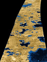
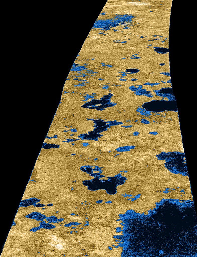
English: Radar image of the Titan surface taken on 22. July 2006 from Cassini probe. We can see liquid lakes of methane in this picture. The image is centered near 80 degrees north, 35 degrees west and is about 140 kilometers (84 miles) across. Smallest details in this image are about 500 meters (1,640 feet) across. The colours are not true.
The view is from Bolsena Lacus in the lower right to Mackay Lacus in the upper left. The names of some of the other laci in the image are given in this map. Some of the features in this image have been annotated in Wikimedia Commons.Deutsch: Seen aus flüssigem Methan auf dem Saturn-Mond Titan. Das Bild zeigt ein etwa 140 Kilometer breites Gebiet nahe 80° Nord 35° West. Falschfarben-Radaraufnahme von Cassini, 2006.
Italiano: Immagine radar in falsi colori della superficie di Titano ripresa il 22 luglio 2006 dalla sonda Cassini; si possono osservare laghi di metano liquido. L'immagine è centrata circa su 80 gradi nord, 35 gradi ovest e copre una vista di circa 140 km. I dettagli più piccoli in questa immagine hanno dimensione di circa 500 metri.
La vista parte dal Bolsena Lacus, in basso a destra, fino al Mackay Lacus in alto a sinistra. |
| Date | |
| Source | http://photojournal.jpl.nasa.gov/catalog/PIA09102 |
| Author | NASA / JPL-Caltech / USGS |
Licensing[edit]
| This file is in the public domain in the United States because it was solely created by NASA. NASA copyright policy states that "NASA material is not protected by copyright unless noted". (See Template:PD-USGov, NASA copyright policy page or JPL Image Use Policy.) | ||
 |
Warnings:
|
| Annotations | This image is annotated: View the annotations at Commons |
File history
Click on a date/time to view the file as it appeared at that time.
| Date/Time | Thumbnail | Dimensions | User | Comment | |
|---|---|---|---|---|---|
| current | 14:50, 24 February 2007 | | 2,600 × 3,400 (1.12 MB) | Kokorik (talk | contribs) | {{Information |Description=Radar image of the Titan surface taken on 22. february 2007 from Cassini probe. We can see liquid lakes of methane in this picture. The image is centered near 80 degrees north, 35 degrees west and is about 140 kilometers (84 mil |
You cannot overwrite this file.
File usage on Commons
The following 2 pages use this file:
File usage on other wikis
The following other wikis use this file:
- Usage on af.wikipedia.org
- Usage on an.wikipedia.org
- Usage on ar.wikipedia.org
- Usage on azb.wikipedia.org
- Usage on be.wikipedia.org
- Партал:Астраномія
- Партал:Астраномія/Як я магу дапамагчы
- Тытан (спадарожнік)
- Мора Кракена
- Шаблон:Гідрасфера Тытана
- Гідрасфера Тытана
- Мора Лігеі
- Мора Пунгі
- Возера Абая (Тытан)
- Возера Альбана (Тытан)
- Возера Атытлан (Тытан)
- Возера Больсена (Тытан)
- Возера Венерн (Тытан)
- Возера Кардыэль (Тытан)
- Возера Каюга (Тытан)
- Возера Ківу (Тытан)
- Возера Кайтэрэ (Тытан)
- Возера Ланаа (Тытан)
- Возера Локтак (Тытан)
- Возера Макай (Тытан)
- Возера Міватн (Тытан)
- Возера Ней (Тытан)
- Возера Анейда (Тытан)
- Возера Ахрыд (Тытан)
- Возера Севан (Тытан)
- Возера Сатанера (Тытан)
- Возера Спароу (Тытан)
- Возера Тавада (Тытан)
- Возера Уўс
- Возера Уэйкэр (Тытан)
- Возера Фея (Тытан)
- Возера Фрымен (Тытан)
- Возера Хунін (Тытан)
- Возера Цзінбо (Тытан)
- Лакуна Атакама
- Лагуна Джэрыд
- Лагуна Мельгір
- Лакуна Нгамі
- Лагуна Рэйстрэк
View more global usage of this file.