File:Lituyabay Earth Observatory image 2020.jpg
Bước tới điều hướng
Bước tới tìm kiếm
Không có độ phân giải cao hơn.
Lituyabay_Earth_Observatory_image_2020.jpg (720×480 điểm ảnh, kích thước tập tin: 489 kB, kiểu MIME: image/jpeg)
Chú thích
Chú thích
Ghi một dòng giải thích những gì có trong tập tin này
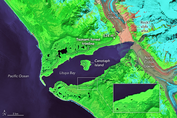
False-color Landsat 8 image of Lituya Bay, 2020
Miêu tả[sửa]
| Miêu tả | NASA Earth Observatory image by Lauren Dauphin, using Landsat data from the U.S. Geological Survey | |||||
| Ngày | ||||||
| Nguồn gốc | https://earthobservatory.nasa.gov/images/147557/lituya-bays-apocalyptic-wave?src=eoa-iotd | |||||
| Tác giả | Lauren Dauphin, NASA Earth Observatory | |||||
| Giấy phép (Dùng lại tập tin) |
|

Lịch sử tập tin
Nhấn vào ngày/giờ để xem nội dung tập tin tại thời điểm đó.
| Ngày/Giờ | Hình xem trước | Kích cỡ | Thành viên | Miêu tả | |
|---|---|---|---|---|---|
| hiện tại | 06:36, ngày 26 tháng 11 năm 2020 | | 720×480 (489 kB) | Tillman (thảo luận | đóng góp) | {{Information |Description= NASA Earth Observatory image by Lauren Dauphin, using Landsat data from the U.S. Geological Survey |Source= https://earthobservatory.nasa.gov/images/147557/lituya-bays-apocalyptic-wave?src=eoa-iotd |Date= July 1, 2020 |Author= Lauren Dauphin, NASA Earth Observatory |Permission= {{PD-USGov-NASA}} |other_versions= }} Category:Files uploaded by PDTillman Category:Lituya Bay megatsunami |
Bạn không được phép ghi đè tập tin này.
Trang sử dụng tập tin
Trang sau sử dụng tập tin này:
Sử dụng tập tin toàn cục
Những wiki sau đang sử dụng tập tin này:
- Trang sử dụng tại en.wikipedia.org
- Trang sử dụng tại it.wikipedia.org
- Trang sử dụng tại ko.wikipedia.org
- Trang sử dụng tại no.wikipedia.org
- Trang sử dụng tại vi.wikipedia.org