File:Localización del movimiento comunero.svg
Jump to navigation
Jump to search

Size of this PNG preview of this SVG file: 738 × 542 pixels. Other resolutions: 320 × 235 pixels | 640 × 470 pixels | 1,024 × 752 pixels | 1,280 × 940 pixels | 2,560 × 1,880 pixels.
Original file (SVG file, nominally 738 × 542 pixels, file size: 509 KB)
Captions
Captions
Add a one-line explanation of what this file represents
Summary
[edit]
| Description |
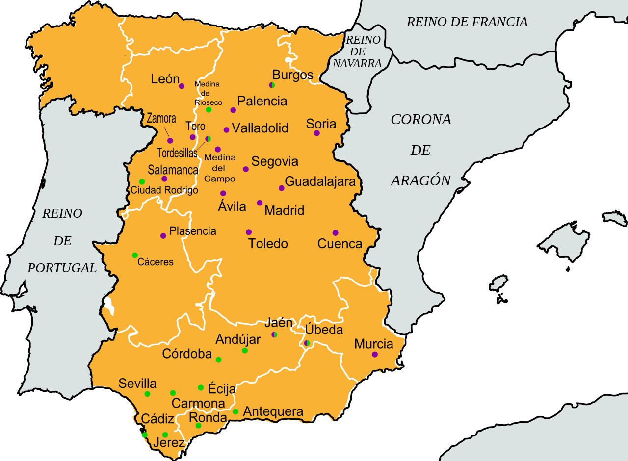
Español: Localización de las ciudades comuneras en la es:Guerra de las Comunidades de Castilla. En morado, las ciudades rebeldes, en verde, las leales al rey. En ambos, las que estuvieron presentes en los dos bandos.
English: A map of city control during the en:Revolt of the Comuneros. Rebel cities are colored purple, royalist cities are colored green. In cities colored half and half, both sides were present. |
| Date | |
| Source | self-made, from image:Corona de Castilla 1400.svg. Source for city control: Díaz Medina, Ana (03-2006). «Héroes de Castilla: Los Comuneros». Historia National Geographic (nº 27): p. 92-103. |
| Author | Rastrojo (D•ES) |
| Other versions | Image:ComunerosCityControl.png (English version). |
Licensing
[edit]
I, the copyright holder of this work, hereby publish it under the following licenses:

|
Permission is granted to copy, distribute and/or modify this document under the terms of the GNU Free Documentation License, Version 1.2 or any later version published by the Free Software Foundation; with no Invariant Sections, no Front-Cover Texts, and no Back-Cover Texts. A copy of the license is included in the section entitled GNU Free Documentation License. |
This file is licensed under the Creative Commons Attribution-Share Alike 4.0 International, 3.0 Unported, 2.5 Generic, 2.0 Generic and 1.0 Generic license.
- You are free:
- to share – to copy, distribute and transmit the work
- to remix – to adapt the work
- Under the following conditions:
- attribution – You must give appropriate credit, provide a link to the license, and indicate if changes were made. You may do so in any reasonable manner, but not in any way that suggests the licensor endorses you or your use.
- share alike – If you remix, transform, or build upon the material, you must distribute your contributions under the same or compatible license as the original.
You may select the license of your choice.
File history
Click on a date/time to view the file as it appeared at that time.
| Date/Time | Thumbnail | Dimensions | User | Comment | |
|---|---|---|---|---|---|
| current | 09:50, 1 April 2021 | | 738 × 542 (509 KB) | OestePurpura (talk | contribs) | Adding Medieval territory limits inside the Crown of Castile (around 1500-1600). |
| 21:39, 21 December 2016 |  | 738 × 542 (564 KB) | Discasto (talk | contribs) | Reverted to version as of 15:48, 21 June 2008 (UTC): per COM:OVERWRITE. Feel free to upload your picture as a different file | |
| 15:58, 15 April 2016 |  | 738 × 542 (516 KB) | OestePurpura (talk | contribs) | Adding Medieval territory limits inside the Crown of Castile (around 1500-1600). | |
| 15:48, 21 June 2008 |  | 738 × 542 (564 KB) | Javitomad (talk | contribs) | Corrección de la situación de Ciudad Rodrigo en el mapa | |
| 15:56, 28 March 2008 |  | 738 × 542 (564 KB) | Rastrojo (talk | contribs) | {{Information |Description=Localización de las ciudades comuneras. En morado, las ciudades rebeldes, en verde, las leales al rey. En ambos, las que estuvieron presentes en los dos bandos. |Source=self-made, from image:Corona de Castilla 1400.svg |Da |
You cannot overwrite this file.
File usage on Commons
The following 8 pages use this file:
- Maps of Spain
- User:Anton-kurt/Tyrol new files/2016 December 21-31
- User:J budissin/Uploads/BiH/2016 December 21-31
- User:Magog the Ogre/Multilingual legend/2021 April 1-10
- User:Mai-Sachme/South Tyrol/2016 April 11-20
- User:Mai-Sachme/South Tyrol/2016 December 21-31
- File:ComunerosCityControl.png
- File:Locations of the comunero movement.svg
File usage on other wikis
The following other wikis use this file:
- Usage on ast.wikipedia.org
- Usage on de.wikipedia.org
- Usage on es.wikipedia.org
- Usage on fr.wikipedia.org
- Usage on gl.wikipedia.org