File:Location map of Bergen County, New Jersey.svg
Jump to navigation
Jump to search

Size of this PNG preview of this SVG file: 700 × 600 pixels. Other resolutions: 280 × 240 pixels | 560 × 480 pixels | 896 × 768 pixels | 1,195 × 1,024 pixels | 2,389 × 2,048 pixels.
Original file (SVG file, nominally 896 × 768 pixels, file size: 874 KB)
Captions
Captions
Add a one-line explanation of what this file represents
Summary[edit]
| Description |
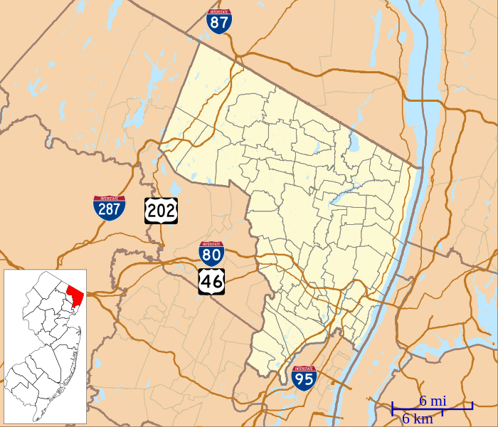
English: This is a map of Bergen County, New Jersey, USA which includes incorporated settlements, township borders, and major highways. |
| Date | |
| Source | My own work, using custom-written MapScript applications with United States Census Bureau data |
| Author | Omnedon |
Licensing[edit]
| I, the copyright holder of this work, release this work into the public domain. This applies worldwide. In some countries this may not be legally possible; if so: I grant anyone the right to use this work for any purpose, without any conditions, unless such conditions are required by law. |
File history
Click on a date/time to view the file as it appeared at that time.
| Date/Time | Thumbnail | Dimensions | User | Comment | |
|---|---|---|---|---|---|
| current | 22:04, 7 October 2012 | | 896 × 768 (874 KB) | Omnedon (talk | contribs) | == {{int:filedesc}} == {{Information |Description={{en|This is a map of Bergen County, New Jersey, USA which includes incorporated settlements, township borders, and major highways.}} |Source=My own work, using custom-w... |
You cannot overwrite this file.
File usage on Commons
There are no pages that use this file.
File usage on other wikis
The following other wikis use this file:
- Usage on ar.wikipedia.org
- Usage on azb.wikipedia.org
- رادبرن، نیوجرسی
- والدویک، نیوجرسی
- کرزسکیل، نیوجرسی
- والینقتون، نیوجرسی
- آلندئیل، نیوجرسی
- نیو میلفورد، نیوجرسی
- تئینک، نیوجرسی
- تتربورو، نیوجرسی
- دمئیرست، نیوجرسی
- نورتوئیل، نیوجرسی
- اواکلاند، نیوجرسی
- دومونت، نیوجرسی
- اولد تاپان، نیوجرسی
- ادجواتر، نیوجرسی
- پاراموس، نیوجرسی
- پارک ریدج، نیوجرسی
- وزت وییو، نیوجرسی
- وزتوود، نیوجرسی
- بوقوتا، نیوجرسی
- قلن روک، نیوجرسی
- رامزئی، نیوجرسی
- ریدجفیلد، نیوجرسی
- ریدقیوود، نیوجرسی
- هاکنزاک، نیوجرسی
- ریور ادج، نیوجرسی
- ریور وئیل، نیوجرسی
- کارلستادت، نیوجرسی
- هیلسدئیل، نیوجرسی
- وود-ریدج، نیوجرسی
- هو-هو-کوس، نیوجرسی
- وورتندیک، نیوجرسی
- لیندهورزت، نیوجرسی
- ماهواه، نیوجرسی
- مایوود، نیوجرسی
- Usage on ceb.wikipedia.org
- Usage on en.wikipedia.org
- Allendale, New Jersey
- Alpine, New Jersey
- Bergenfield, New Jersey
- Bogota, New Jersey
- Cliffside Park, New Jersey
- Closter, New Jersey
- Dumont, New Jersey
- Elmwood Park, New Jersey
- Emerson, New Jersey
- Englewood, New Jersey
- Fair Lawn, New Jersey
- Franklin Lakes, New Jersey
- Hasbrouck Heights, New Jersey
- Hillsdale, New Jersey
View more global usage of this file.