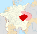
File:Locator Bohemia within the Holy Roman Empire (1618).svg
From Wikimedia Commons, the free media repository
Jump to navigation
Jump to search

Size of this PNG preview of this SVG file: 658 × 600 pixels. Other resolutions: 263 × 240 pixels | 527 × 480 pixels | 843 × 768 pixels | 1,123 × 1,024 pixels | 2,247 × 2,048 pixels | 2,769 × 2,524 pixels.
Original file (SVG file, nominally 2,769 × 2,524 pixels, file size: 1,021 KB)
File information
Structured data
Captions
Captions
Locator Map of the Kingdom of Bohemia
Bohemya'nın Kutsal Roma İmparatorluğu ile nerede olduğunu gösteren harita (1618)
Summary
[edit]| DescriptionLocator Bohemia within the Holy Roman Empire (1618).svg |
English: Locator Map of the Kingdom of Bohemia (proper) within the Holy Roman Empire (1618)
Nederlands: Locatiekaart van het Koninkrijk Bohemen binnen het Heilige Roomse Rijk (1618) |
| Date | |
| Source |
|
| Author |
This W3C-unspecified vector image was created with Inkscape . |
Licensing
[edit]I, the copyright holder of this work, hereby publish it under the following license:
This file is licensed under the Creative Commons Attribution-Share Alike 4.0 International license.
- You are free:
- to share – to copy, distribute and transmit the work
- to remix – to adapt the work
- Under the following conditions:
- attribution – You must give appropriate credit, provide a link to the license, and indicate if changes were made. You may do so in any reasonable manner, but not in any way that suggests the licensor endorses you or your use.
- share alike – If you remix, transform, or build upon the material, you must distribute your contributions under the same or compatible license as the original.
File history
Click on a date/time to view the file as it appeared at that time.
| Date/Time | Thumbnail | Dimensions | User | Comment | |
|---|---|---|---|---|---|
| current | 21:32, 13 May 2019 |  | 2,769 × 2,524 (1,021 KB) | Ernio48 (talk | contribs) | Not a separate Land of the Bohemian Crown. There were 5 Lands. Eger was part of the Kingdom of Bohemia. Virtually every historical map includes it as its part. |
| 00:23, 13 May 2019 |  | 2,769 × 2,524 (1,023 KB) | David Beneš (talk | contribs) | Restored. The fact is stated in every WP article about Egerland/Chebsko, cf. the sources there. | |
| 15:53, 11 May 2019 |  | 2,769 × 2,524 (1,021 KB) | Ernio48 (talk | contribs) | Reverted to version as of 09:56, 30 April 2016 (UTC) Needs proof. | |
| 13:59, 23 June 2016 |  | 2,769 × 2,524 (1,023 KB) | David Beneš (talk | contribs) | Not the Land of Eger (a separate unit by then). | |
| 09:56, 30 April 2016 |  | 2,769 × 2,524 (1,021 KB) | David Beneš (talk | contribs) | + the County of Glaz. | |
| 07:13, 25 April 2016 |  | 2,769 × 2,524 (1,024 KB) | Der Golem (talk | contribs) | +Lands of the Bohemian Crown | |
| 00:48, 28 January 2015 |  | 2,769 × 2,524 (1,024 KB) | Sir Iain (talk | contribs) | Corrected Bohemian border | |
| 13:58, 27 January 2015 |  | 2,769 × 2,524 (1,014 KB) | Sir Iain (talk | contribs) | Redone Schleswig-Holstein | |
| 00:55, 5 January 2015 |  | 2,769 × 2,524 (994 KB) | Sir Iain (talk | contribs) | Savoy shown as core territory of the HRR | |
| 20:28, 23 December 2014 |  | 2,769 × 2,524 (994 KB) | Sir Iain (talk | contribs) | Removed the Imperial border between Germany and the Netherlands |
You cannot overwrite this file.
File usage on Commons
The following 5 pages use this file:
File usage on other wikis
The following other wikis use this file:
- Usage on ar.wikipedia.org
- Usage on arz.wikipedia.org
- Usage on ast.wikipedia.org
- Usage on ba.wikipedia.org
- Usage on ca.wikipedia.org
- Usage on cs.wikipedia.org
- Usage on da.wikipedia.org
- Usage on de.wikipedia.org
- Usage on de.wikibooks.org
- Usage on el.wikipedia.org
- Usage on en.wikipedia.org
- Usage on eo.wikipedia.org
- Usage on es.wikipedia.org
- Usage on et.wikipedia.org
- Usage on fa.wikipedia.org
- Usage on fi.wikipedia.org
- Usage on frr.wikipedia.org
- Usage on fr.wikipedia.org
- Usage on ga.wikipedia.org
- Usage on gl.wikipedia.org
- Usage on hr.wikipedia.org
- Usage on hu.wikipedia.org
- Usage on id.wikipedia.org
- Usage on it.wikipedia.org
- Usage on ja.wikipedia.org
- Usage on ko.wikipedia.org
- Usage on ku.wikipedia.org
- Usage on la.wikipedia.org
- Usage on lt.wikipedia.org
- Usage on lv.wikipedia.org
- Usage on mk.wikipedia.org
- Usage on nl.wikipedia.org
- Usage on no.wikipedia.org
- Usage on pl.wikipedia.org
View more global usage of this file.
Metadata
This file contains additional information such as Exif metadata which may have been added by the digital camera, scanner, or software program used to create or digitize it. If the file has been modified from its original state, some details such as the timestamp may not fully reflect those of the original file. The timestamp is only as accurate as the clock in the camera, and it may be completely wrong.
| Width | 2769.4062 |
|---|---|
| Height | 2524.3125 |