File:London - John Norden's map of 1593.jpg

File originale (4 000 × 3 760 pixel, dimensione del file: 4,01 MB, tipo MIME: image/jpeg)
Didascalie
Didascalie
| Descrizione |
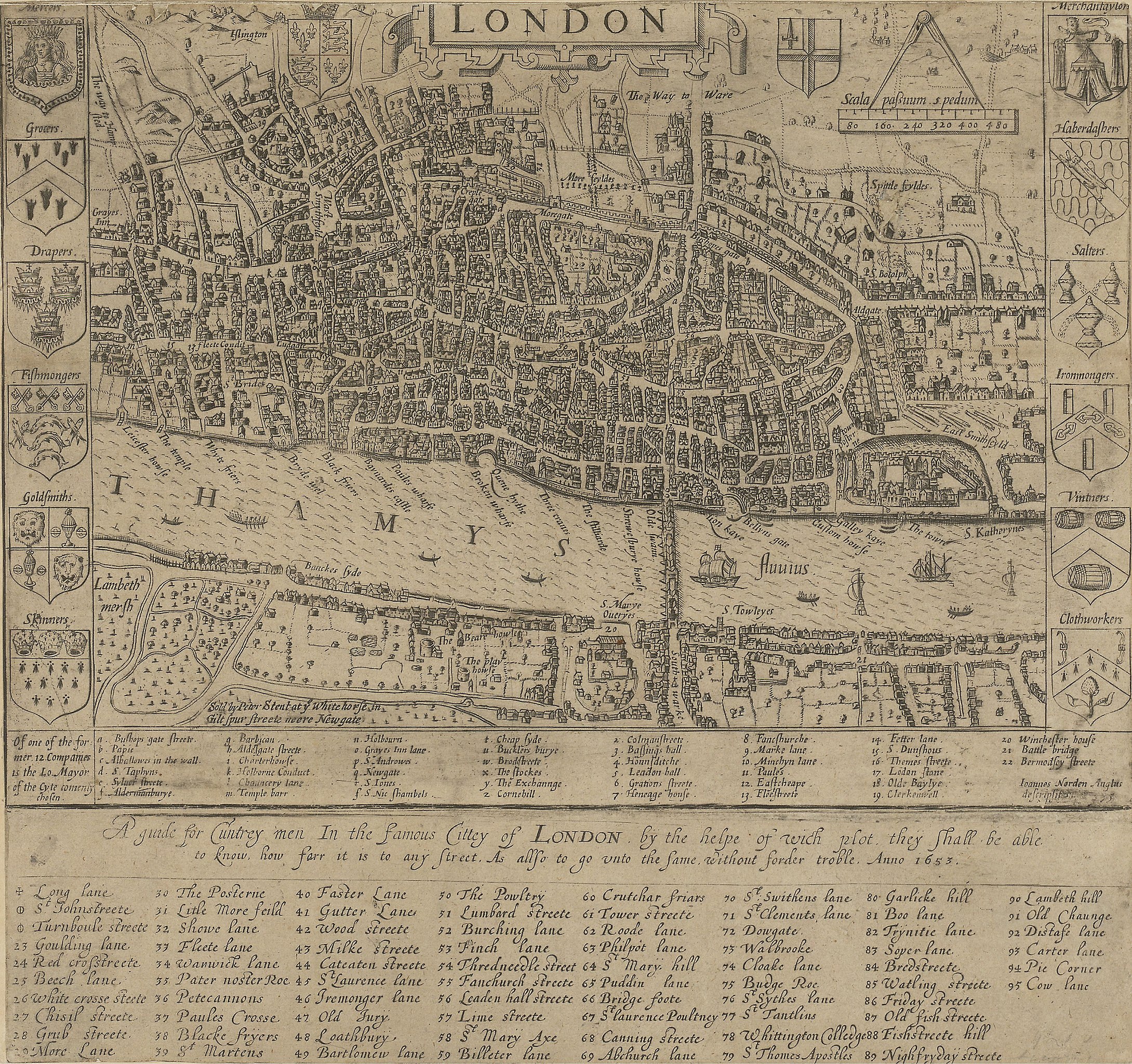
English: A guide for Cuntrey men In the famous Cittey of London. A map of London by John Norden, 1593. This copy comes from the 1653 edition of Norden's Speculum Britainiæ (Mirror of Britain), re-issued after his death.
There is only one bridge across the Thames, but parts of Southwark on the south bank of the river have been developed. The coats of arms around the edge belong to the twelve largest city guilds. These arms collectively were known as the "Great Liveries". Top right is the Merchant Tailors' arms.
|
||||
| Data | 1593, re-issued in 1653 | ||||
| Fonte | British Library: http://www.bl.uk/onlinegallery/onlineex/crace/a/007000000000001u00033000.html | ||||
| Autore | John Norden | ||||
| Licenza (Riusare questo file) |
|
||||
Cronologia del file
Fare clic su un gruppo data/ora per vedere il file come si presentava nel momento indicato.
| Data/Ora | Miniatura | Dimensioni | Utente | Commento | |
|---|---|---|---|---|---|
| attuale | 02:49, 19 feb 2010 | | 4 000 × 3 760 (4,01 MB) | Inductiveload (discussione | contributi) | much higher res version |
| 10:54, 21 mag 2007 |  | 500 × 335 (43 KB) | Thomas Reid (discussione | contributi) | {{Information |Description=John Norden's map of London in 1593. There is only one bridge across the Thames, but parts of en:Southwark on the south bank of the river have been developed. |Source=Originally from [http://en.wikipedia.org en.wikipedia]; |
Impossibile sovrascrivere questo file.
Utilizzo del file
Nessuna pagina utilizza questo file.
Utilizzo globale del file
Anche i seguenti wiki usano questo file:
- Usato nelle seguenti pagine di ar.wikipedia.org:
- Usato nelle seguenti pagine di be-tarask.wikipedia.org:
- Usato nelle seguenti pagine di be.wikipedia.org:
- Usato nelle seguenti pagine di bg.wikipedia.org:
- Usato nelle seguenti pagine di en.wikipedia.org:
- Usato nelle seguenti pagine di en.wikibooks.org:
- Usato nelle seguenti pagine di eo.wikipedia.org:
- Usato nelle seguenti pagine di es.wikipedia.org:
- Usato nelle seguenti pagine di fa.wikipedia.org:
- Usato nelle seguenti pagine di ga.wikipedia.org:
- Usato nelle seguenti pagine di he.wikipedia.org:
- Usato nelle seguenti pagine di hr.wikipedia.org:
- Usato nelle seguenti pagine di hu.wikipedia.org:
- Usato nelle seguenti pagine di hy.wikipedia.org:
- Usato nelle seguenti pagine di it.wikipedia.org:
- Usato nelle seguenti pagine di ja.wikipedia.org:
- Usato nelle seguenti pagine di kn.wikipedia.org:
- Usato nelle seguenti pagine di ko.wikipedia.org:
- Usato nelle seguenti pagine di my.wikipedia.org:
- Usato nelle seguenti pagine di ro.wikipedia.org:
- Usato nelle seguenti pagine di ru.wikipedia.org:
- Usato nelle seguenti pagine di sco.wikipedia.org:
- Usato nelle seguenti pagine di sh.wikipedia.org:
- Usato nelle seguenti pagine di sl.wikipedia.org:
- Usato nelle seguenti pagine di tum.wikipedia.org:
- Usato nelle seguenti pagine di uk.wikipedia.org:
- Usato nelle seguenti pagine di vi.wikipedia.org:
- Usato nelle seguenti pagine di zh.wikipedia.org: