File:Map Italy around 500 b.C. - Touring Club Italiano CART-TRC-40.jpg
Vai alla navigazione
Vai alla ricerca

Dimensioni di questa anteprima: 545 × 600 pixel. Altre risoluzioni: 218 × 240 pixel | 436 × 480 pixel | 698 × 768 pixel | 931 × 1 024 pixel | 1 862 × 2 048 pixel | 6 046 × 6 651 pixel.
File originale (6 046 × 6 651 pixel, dimensione del file: 4,22 MB, tipo MIME: image/jpeg)
Didascalie
Didascalie
Aggiungi una brevissima spiegazione di ciò che questo file rappresenta
Dettagli[modifica]
| Titolo |
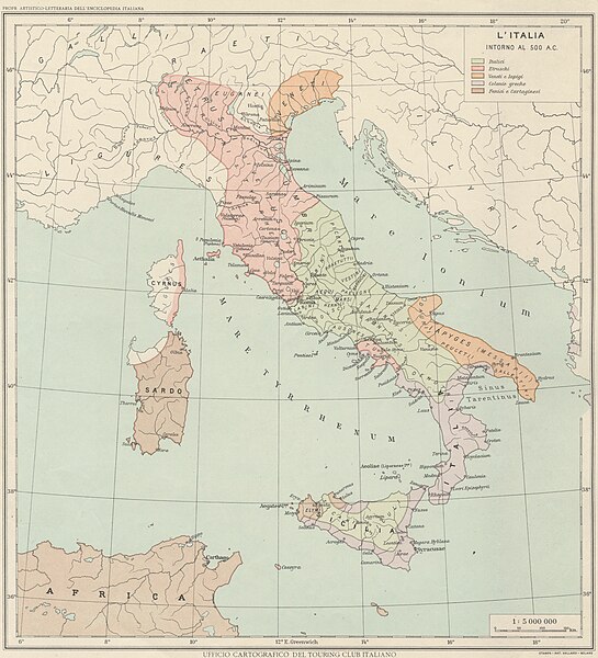
Italy around 500 B.C. |
|
| Descrizione |
English: The map shows Italy around 500 B.C., when it was populated by Italics, Etruscans, Venetians and Iapigis, Greeks, Phoenicians and Carthaginians. The map is one of the tables made by the TCI Cartographic Office for the Italian Encyclopedia of Giovanni Treccani Institute Italiano: La mappa mostra l'Italia intorno al 500 a.C., quando era popolata da Italici, Etruschi, Veneti e Iapigi, Greci, Fenici e Cartaginesi. La mappa è una delle tavole realizzate dall'Ufficio Cartografico del TCI per l'Enciclopedia italiana Giovanni Treccani |
|
| Data | tra il 1928 e il 1940 | |
| Licenza (Riusare questo file) |
|
|
| Geotemporal data | ||
| Data rappresentata | B.C. | |
| Map location | Italy | |
| Map type | Maps showing history | |
| Scala | 1: 5 000 000 | |
| Georeferencing | If inappropriate please set warp_status = skip to hide. | |
| Bibliographic data | ||
| Stampato da |
Vallardi |
|
| Archival data | ||
| Numero d'inventario |
CART.TRC.40 |
|
Licenza[modifica]
Cronologia del file
Fare clic su un gruppo data/ora per vedere il file come si presentava nel momento indicato.
| Data/Ora | Miniatura | Dimensioni | Utente | Commento | |
|---|---|---|---|---|---|
| attuale | 14:28, 19 ott 2022 | | 6 046 × 6 651 (4,22 MB) | Marta Arosio (WMIT) (discussione | contributi) | Cropped 13 % horizontally, 11 % vertically using CropTool with lossless mode. |
| 12:58, 13 ott 2022 |  | 6 945 × 7 495 (5,35 MB) | Ilaria Parma (TCI) (discussione | contributi) | pattypan 22.03 |
Impossibile sovrascrivere questo file.
Utilizzo del file
Le seguenti 2 pagine usano questo file:
Utilizzo globale del file
Anche i seguenti wiki usano questo file:
- Usato nelle seguenti pagine di en.wikipedia.org:
- Usato nelle seguenti pagine di it.wikipedia.org:
- Usato nelle seguenti pagine di outreach.wikimedia.org:
- Usato nelle seguenti pagine di www.wikidata.org:
Metadati
Categorie:
- 1930s maps of Italy
- Maps of ancient Rome
- Maps by TCI Cartographic Office
- Enciclopedia Treccani - Maps
- 5th century BC
- 1930s maps showing history
- Touring Club Italiano maps showing history
- Italian-language maps showing history
- Italian-language maps showing history of Europe
- 1930s maps from Archivio Storico Touring Club Italiano