File:Map of Sveaborg at the 1790s.png
Bước tới điều hướng
Bước tới tìm kiếm
Kích thước hình xem trước: 348×599 điểm ảnh. Độ phân giải khác: 139×240 điểm ảnh | 374×644 điểm ảnh.
Tập tin gốc (374×644 điểm ảnh, kích thước tập tin: 27 kB, kiểu MIME: image/png)
Chú thích
Chú thích
Ghi một dòng giải thích những gì có trong tập tin này
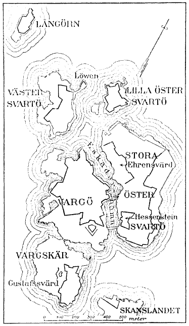
Map of Sveaborg at the 1790s.
From English Wikipedia: en:Image:Map of Sveaborg at the 1790s.png
Original source: Nordisk familjebok (1918), vol.27, p.882 [1]
This image was first published in the 1st (1876–1899), 2nd (1904–1926) or 3rd (1923–1937) edition of Nordisk familjebok. The copyrights for that book have expired and this image is in the public domain, because images had no named authors and the book was published more than 70 years ago.
|
This image (or other media file) is in the public domain because its copyright has expired and its author is anonymous.
This applies to the European Union and those countries with a copyright term of 70 years after the work was made available to the public and the author never disclosed their identity. Important: Always mention where the image comes from, as far as possible, and make sure the author never claimed authorship. |
 | |
 |
Note: In Germany and possibly other countries, certain anonymous works published before July 1, 1995 are copyrighted until 70 years after the death of the author. See Übergangsrecht. Please use this template only if the author never claimed authorship or their authorship never became public in any other way. If the work is anonymous or pseudonymous (e.g., published only under a corporate or organization's name), use this template for images published more than 70 years ago.
For a work made available to the public in the United Kingdom, please use Template:PD-UK-unknown instead.
|
Lịch sử tập tin
Nhấn vào ngày/giờ để xem nội dung tập tin tại thời điểm đó.
| Ngày/Giờ | Hình xem trước | Kích cỡ | Thành viên | Miêu tả | |
|---|---|---|---|---|---|
| hiện tại | 20:25, ngày 1 tháng 8 năm 2005 | | 374×644 (27 kB) | Tomisti (thảo luận | đóng góp) | Map of Sveaborg at the 1790s. From English Wikipedia: en:Image:Map of Sveaborg at the 1790s.png <br> Original source: Nordisk familjebok {{PD}} |
Bạn không được phép ghi đè tập tin này.
Trang sử dụng tập tin
2 trang sau sử dụng tập tin này:
Sử dụng tập tin toàn cục
Những wiki sau đang sử dụng tập tin này:
- Trang sử dụng tại en.wikipedia.org
- Trang sử dụng tại eo.wikipedia.org
- Trang sử dụng tại eu.wikipedia.org
- Trang sử dụng tại fr.wikipedia.org
- Trang sử dụng tại hy.wikipedia.org
- Trang sử dụng tại it.wikipedia.org
- Trang sử dụng tại ms.wikipedia.org
- Trang sử dụng tại nn.wikipedia.org
- Trang sử dụng tại ru.wikipedia.org
- Trang sử dụng tại sv.wikipedia.org
- Trang sử dụng tại vi.wikipedia.org
- Trang sử dụng tại zh.wikipedia.org