File:Map of route of Black Prince chevauchée of 1355.svg
Vai alla navigazione
Vai alla ricerca

Dimensioni di questa anteprima PNG per questo file SVG: 725 × 599 pixel. Altre risoluzioni: 290 × 240 pixel | 581 × 480 pixel | 929 × 768 pixel | 1 239 × 1 024 pixel | 2 478 × 2 048 pixel | 1 049 × 867 pixel.
File originale (file in formato SVG, dimensioni nominali 1 049 × 867 pixel, dimensione del file: 427 KB)
Didascalie
Didascalie
Aggiungi una brevissima spiegazione di ciò che questo file rappresenta
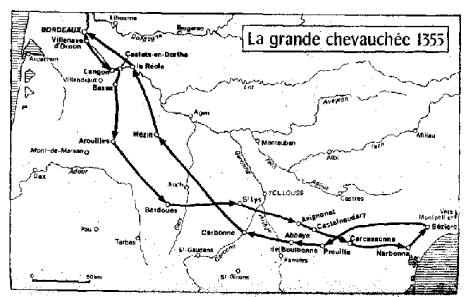
Route of Black Prince's chevauchée of 1355
Dettagli[modifica]
| Descrizione |
English: Map of the route of the Black Prince's chevauchée of 1355, part of the Hundred Years' War. This map shows the Black Prince's movements during the campaign.
|
|||||||||||||||||||||
| Data | ||||||||||||||||||||||
| Fonte |
Opera propria Derived from; Information from:
|
|||||||||||||||||||||
| Autore | Goran_tek-en | |||||||||||||||||||||
| Licenza (Riusare questo file) |
Questo file è disponibile in base alla licenza Creative Commons Attribuzione-Condividi allo stesso modo 4.0 Internazionale Attribuzione: Goran tek-en
|
|||||||||||||||||||||
| Altre versioni |
|
|||||||||||||||||||||
| SVG sviluppo | Questa grafica vettoriale è stata creata con Inkscape. |
|||||||||||||||||||||


| Posizione del soggetto | | Posizione di questa e altre immagini su: OpenStreetMap |
|---|


Cronologia del file
Fare clic su un gruppo data/ora per vedere il file come si presentava nel momento indicato.
| Data/Ora | Miniatura | Dimensioni | Utente | Commento | |
|---|---|---|---|---|---|
| attuale | 15:45, 9 nov 2021 | | 1 049 × 867 (427 KB) | Goran tek-en (discussione | contributi) | Changed view box, font size |
| 11:26, 1 dic 2019 |  | 1 049 × 867 (439 KB) | Goran tek-en (discussione | contributi) | {{Information |description ={{en|1=Map of the route of the Black Prince's chevauchée of 1355, part of the Hundred Years' War. This map shows the Black Prince's movements during the campaign}} |date = |source ={{Own}}<br> {{Derived from|Ccaa-spain.png|BlankMap-World gray.svg}} Derived from; * [https://www.openstreetmap.org/#map=7/43.787/1.664 OSM] Information from: * [https://conservancy.umn.edu/bitstream/handle/11299/171443/Madden_umn_0130E_15639.pdf page 10] * [http:/... |
Impossibile sovrascrivere questo file.
Utilizzo del file
Le seguenti 6 pagine usano questo file:
Utilizzo globale del file
Anche i seguenti wiki usano questo file:
- Usato nelle seguenti pagine di en.wikipedia.org:
- Usato nelle seguenti pagine di it.wikipedia.org:
- Usato nelle seguenti pagine di sh.wikipedia.org: