File:Map of traditional provinces of Libye-en.svg
Jump to navigation
Jump to search

Size of this PNG preview of this SVG file: 625 × 599 pixels. Other resolutions: 250 × 240 pixels | 501 × 480 pixels | 801 × 768 pixels | 1,068 × 1,024 pixels | 2,136 × 2,048 pixels | 969 × 929 pixels.
Original file (SVG file, nominally 969 × 929 pixels, file size: 106 KB)
Captions
Captions
Add a one-line explanation of what this file represents
| Description |
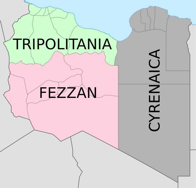
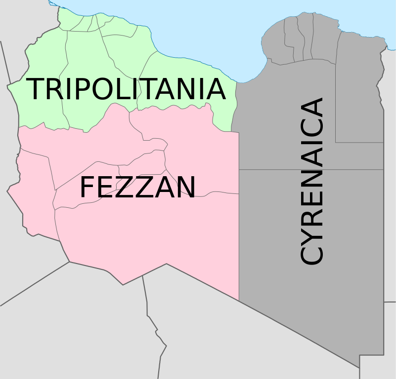
Deutsch: Historische provinzen (Governorates) Libyens English: Map of the three Governorates of Libya based on the borders of today's governorates. After independence in 1951, until 1963, Libya was divided into three governorates (muhafazat): Cyrenaica, Tripolitania, and Fezzan. The eastern border between Tripolitania and Fezzan was before 1969 slightly different: the northern part of Al Jufrah District in today's Fezzan belonged to Tripolitania, see here File:Ottoman Provinces Of Present day Libyapng.png. Español: Mapa de las tres governorates de Libia: Tripolitania, Fezzan, y Cirenaica. Français : Carte en anglais des trois provinces historiques (gouvernorats) de la Libye contemporaine. |
| Date | (UTC) |
| Source | |
| Author |
|
| Other versions |
|


| This is a retouched picture, which means that it has been digitally altered from its original version. Modifications: translation in english. The original can be viewed here: Map of traditionnal provinces of Libye fr.svg:
|
I, the copyright holder of this work, hereby publish it under the following licenses:
This file is licensed under the Creative Commons Attribution 3.0 Unported license.
- You are free:
- to share – to copy, distribute and transmit the work
- to remix – to adapt the work
- Under the following conditions:
- attribution – You must give appropriate credit, provide a link to the license, and indicate if changes were made. You may do so in any reasonable manner, but not in any way that suggests the licensor endorses you or your use.

|
Permission is granted to copy, distribute and/or modify this document under the terms of the GNU Free Documentation License, Version 1.2 or any later version published by the Free Software Foundation; with no Invariant Sections, no Front-Cover Texts, and no Back-Cover Texts. A copy of the license is included in the section entitled GNU Free Documentation License. |
You may select the license of your choice.
Original upload log[edit]
This image is a derivative work of the following images:
- File:Map_of_traditionnal_provinces_of_Libye_fr.svg licensed with Cc-by-3.0, GFDL
- 2011-02-25T14:34:29Z Пакко 969x929 (120204 Bytes) upg
- 2011-02-25T13:46:48Z Xfigpower 970x931 (162661 Bytes) {{Information |Description={{fr|les trois provinces mappées sur la arte actuelle de la LibyeLes couleurs sont celles symbolisées par le drapeau}} |Source=*[[:File:Libya_location_map.svg|]] |Date=2011-02-25 13:29 (UTC) |Auth
Uploaded with derivativeFX
File history
Click on a date/time to view the file as it appeared at that time.
| Date/Time | Thumbnail | Dimensions | User | Comment | |
|---|---|---|---|---|---|
| current | 08:36, 24 August 2021 | | 969 × 929 (106 KB) | أحمد الغرباوي (talk | contribs) | File uploaded using svgtranslate tool (https://svgtranslate.toolforge.org/). Added translation for ar. |
| 15:44, 6 December 2020 |  | 969 × 929 (104 KB) | ידידיה צ' צבאן (talk | contribs) | File uploaded using svgtranslate tool (https://svgtranslate.toolforge.org/). Added translation for he. | |
| 03:46, 12 October 2011 |  | 969 × 929 (104 KB) | Spesh531 (talk | contribs) | updated to current internal boundaries | |
| 12:50, 30 August 2011 |  | 969 × 929 (147 KB) | Orange Tuesday (talk | contribs) | see http://www.crwflags.com/fotw/flags/ly_1951.html for source on traditional colours | |
| 01:40, 30 August 2011 |  | 969 × 929 (124 KB) | Hellerick (talk | contribs) | Found no information on "traditional association" | |
| 20:24, 13 June 2011 |  | 969 × 929 (147 KB) | Kmusser (talk | contribs) | shift colors to match traditional association | |
| 11:04, 29 April 2011 |  | 969 × 929 (125 KB) | Hellerick (talk | contribs) | Neutral colors; + foreign nations borders | |
| 13:02, 16 March 2011 |  | 969 × 929 (121 KB) | Bourrichon (talk | contribs) | typo | |
| 13:01, 16 March 2011 |  | 969 × 929 (121 KB) | Bourrichon (talk | contribs) | +bug typo | |
| 12:58, 16 March 2011 |  | 969 × 929 (112 KB) | Bourrichon (talk | contribs) | {{Information |Description={{de|Historische provinzen (Governorates) Libyens}} {{en| Map of the three '''{{w|Governorates of Libya}}'''. After independence in 1951, until 1963, Libya was divided into three governorates (''{{w|muhafazat}}''): '''{{w|Cyrena |
You cannot overwrite this file.
File usage on Commons
The following 10 pages use this file:
- File:Map of traditional provinces of Libye-ar.png
- File:Map of traditional provinces of Libye-ar.svg
- File:Map of traditional provinces of Libye-ka.png
- File:Map of traditional provinces of Libye-no.svg
- File:Map of traditional provinces of Libye-pt.svg
- File:Map of traditionnal provinces of Libye-en.svg (file redirect)
- File:Ottoman Provinces Of Present day Libya.png
- Category:Cyrenaica
- Category:Postage stamps of Cyrenaica
- Category:Stamps of Italian Libya
File usage on other wikis
The following other wikis use this file:
- Usage on ast.wikipedia.org
- Usage on az.wikipedia.org
- Usage on bs.wikipedia.org
- Usage on ca.wikipedia.org
- Usage on cs.wikipedia.org
- Usage on diq.wikipedia.org
- Usage on en.wikipedia.org
- History of Libya
- Libya
- Geography of Libya
- Demographics of Libya
- Politics of Libya
- Economy of Libya
- Mass media in Libya
- Transport in Libya
- Armed Forces of the Libyan Arab Jamahiriya
- Foreign relations of Libya under Muammar Gaddafi
- Fatimid Caliphate
- Idris of Libya
- List of cities in Libya
- Operation Sonnenblume
- Libyan dinar
- List of heads of state of Libya
- Districts of Libya
- Great Man-Made River
- List of colonial governors of Italian Cyrenaica
- List of heads of government of Libya
- Music of Libya
- Elections in Libya
- Karamanli dynasty
- Ahmed Karamanli
- Culture of Libya
- Central Bank of Libya
- Public Scout and Girl Guide Movement
- General People's Congress (Libya)
- Human rights in Libya
- Subdivisions of Libya
- Provinces of Libya
- Islamic Tripolitania and Cyrenaica
- Ottoman Tripolitania
- Italian colonization of Libya
- History of Libya under Muammar Gaddafi
- Chadian–Libyan War
- Ancient Libya
- Template:Libya topics
- Media of Libya
- Kingdom of Libya
- Minister of Foreign Affairs (Libya)
View more global usage of this file.