File:My Public Lands Roadtrip- Craters of the Moon National Monument in Idaho (18801359775).jpg

File originale (2 000 × 1 325 pixel, dimensione del file: 2,67 MB, tipo MIME: image/jpeg)
Didascalie
Didascalie
Dettagli
[modifica].jpg&action=edit§ion=1)
| Descrizione |
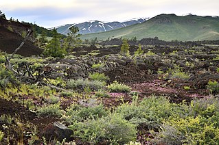
Managed jointly by the BLM and National Park Service, Craters of the Moon National Monument is a uniquely preserved volcanic landscape whose central focus is the Great Rift, a 62-mile long crack in the Earth’s crust. Craters, cinder coves, lava tubes, deep cracks and vast lava fields form a strangely beautiful volcanic sea on central Idaho’s Snake River Plain. Local legends made references to the landscape resembling the surface of the moon. In fact, the second group of astronauts to walk on the moon visited Craters of the Moon in 1969 to study the volcanic geology and to explore an unusual and harsh environment in preparation for their trip to space. Researchers continue to study the area - particularly the caves within the monument and nearby BLM Areas of Critical Environmental Concern. A number of the caves provide hibernation habitat for Townsend’s big-eared bats, a sensitive species. And they provide a great learning resource for local students. |
| Data | |
| Fonte | My Public Lands Roadtrip: Craters of the Moon National Monument in Idaho |
| Autore | Bureau of Land Management |
Licenza
[modifica].jpg&action=edit§ion=2)
- Tu sei libero:
- di condividere – di copiare, distribuire e trasmettere quest'opera
- di modificare – di adattare l'opera
- Alle seguenti condizioni:
- attribuzione – Devi fornire i crediti appropriati, un collegamento alla licenza e indicare se sono state apportate modifiche. Puoi farlo in qualsiasi modo ragionevole, ma non in alcun modo che suggerisca che il licenziante approvi te o il tuo uso.
| Questa immagine è stata originariamente caricata su Flickr da mypubliclands all'indirizzo https://flickr.com/photos/91981596@N06/18801359775. È stata controllata in data 5 agosto 2015 dal robot FlickreviewR ed è stato confermato il suo rilascio sotto i termini della licenza cc-by-2.0. |
| This image is a work of a Bureau of Land Management* employee, taken or made as part of that person's official duties. As a work of the U.S. federal government, the image is in the public domain in the United States. *or predecessor organization |
Cronologia del file
Fare clic su un gruppo data/ora per vedere il file come si presentava nel momento indicato.
| Data/Ora | Miniatura | Dimensioni | Utente | Commento | |
|---|---|---|---|---|---|
| attuale | 18:44, 4 ago 2015 | | 2 000 × 1 325 (2,67 MB) | Wilfredor (discussione | contributi) | Transferred from Flickr via Flickr2Commons |
Impossibile sovrascrivere questo file.
Utilizzo del file
Nessuna pagina utilizza questo file.
Utilizzo globale del file
Anche i seguenti wiki usano questo file:
- Usato nelle seguenti pagine di de.wikipedia.org:
- Usato nelle seguenti pagine di en.wikipedia.org:
- Usato nelle seguenti pagine di it.wikipedia.org:
.jpg&oldid=888104201)