File:Nanmadol 2004-12-01 0200Z.jpg
Bước tới điều hướng
Bước tới tìm kiếm

Kích thước hình xem trước: 453×599 điểm ảnh. Độ phân giải khác: 181×240 điểm ảnh | 363×480 điểm ảnh | 581×768 điểm ảnh | 774×1.024 điểm ảnh | 1.548×2.048 điểm ảnh | 6.200×8.200 điểm ảnh.
Tập tin gốc (6.200×8.200 điểm ảnh, kích thước tập tin: 6,83 MB, kiểu MIME: image/jpeg)
Chú thích
Chú thích
Ghi một dòng giải thích những gì có trong tập tin này
Miêu tả
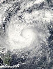
[sửa]| Miêu tả | The MODIS instrument onboard NASA's Terra satellite captured this true-color image of Typhoon Nanmadol at 02:00 UTC on December 1, 2004. At the time this image was taken Nanmadol was located approximately 390 miles west-northwest of Yap and was moving at a brisk 28 mph towards the west-northwest. Maximum sustained winds were near 120 mph with higher gusts to 150 mph. | |||||
| Ngày | ||||||
| Nguồn gốc | http://earthobservatory.nasa.gov/NaturalHazards/natural_hazards_v2.php3?img_id=12597 | |||||
| Tác giả | NASA image created by Jesse Allen, Earth Observatory, using data obtained from the MODIS Rapid Response team. | |||||
| Giấy phép (Dùng lại tập tin) |
|

Lịch sử tập tin
Nhấn vào ngày/giờ để xem nội dung tập tin tại thời điểm đó.
| Ngày/Giờ | Hình xem trước | Kích cỡ | Thành viên | Miêu tả | |
|---|---|---|---|---|---|
| hiện tại | 18:13, ngày 29 tháng 9 năm 2020 | | 6.200×8.200 (6,83 MB) | FleurDeOdile (thảo luận | đóng góp) | center |
| 03:32, ngày 22 tháng 11 năm 2006 |  | 7.099×7.099 (5,22 MB) | Good kitty (thảo luận | đóng góp) | == Summary == {{Information |Description=The MODIS instrument onboard NASA's Terra satellite captured this true-color image of Typhoon Nanmadol at 02:00 UTC on December 1, 2004. At the time this image was taken Nanmadol was located approximately 390 miles |
Bạn không được phép ghi đè tập tin này.
Trang sử dụng tập tin
Trang sau sử dụng tập tin này:
- File:Typhoon Nanmadol 01 dec 2004 0200Z.jpg (tập tin đổi hướng)
Sử dụng tập tin toàn cục
Những wiki sau đang sử dụng tập tin này:
- Trang sử dụng tại en.wikipedia.org
- Trang sử dụng tại ko.wikipedia.org
- Trang sử dụng tại pt.wikipedia.org
- Trang sử dụng tại vi.wikipedia.org