File:Non-Native-American-Nations-Territorial-Claims-over-NAFTA-countries-1750-2008.gif
Bước tới điều hướng
Bước tới tìm kiếm
Kích thước hình xem trước: 536×600 điểm ảnh. Độ phân giải khác: 214×240 điểm ảnh | 429×480 điểm ảnh | 670×750 điểm ảnh.
Tập tin gốc (670×750 điểm ảnh, kích thước tập tin: 741 kB, kiểu MIME: image/gif, có lặp, 97 khung ảnh, 1 min 56 s)
Chú thích
Chú thích
Ghi một dòng giải thích những gì có trong tập tin này
For notes on the individual border changes see Territorial evolution of North America. To make your own animated image use the slides below:
| France | |||
| Present day Canada | |||
|---|---|---|---|
| Canada | |||
| Dominion of Newfoundland | |||
| France | |||
| Britain | |||
| Present day USA | |||
| United States of America | |||
| California Republic | |||
| Confederate States of America | |||
| France | |||
| Republic of Indian Stream | No flag | ||
| Republic of Texas | |||
| Republic of Vermont | |||
| Republic of West Florida | |||
| Russia | |||
| Spain | |||
| Britain | |||
| Present day Mexico | |||
| Federal Republic of Central America | |||
| Mexico | |||
| Spain | |||
| Republic of the Rio Grande | |||
| Yucatán | |||
Images
[sửa]


See Also
[sửa]-
 |North America
 -
 |Central America
 -
 |Balkans
 -
 |South America
 -

-

-


Miêu tả
[sửa]
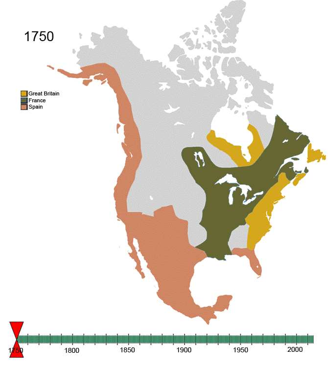
| Miêu tả | Non-Native-American Nation's Control over North America circa 1750-2008 | ||
| Ngày | Created March, 2008 | ||
| Nguồn gốc | Tác phẩm được tạo bởi người tải lên | ||
| Tác giả | Esemono | ||
| Giấy phép (Dùng lại tập tin) |
|
Lịch sử tập tin
Nhấn vào ngày/giờ để xem nội dung tập tin tại thời điểm đó.
| Ngày/Giờ | Hình xem trước | Kích cỡ | Thành viên | Miêu tả | |
|---|---|---|---|---|---|
| hiện tại | 14:32, ngày 21 tháng 1 năm 2010 | | 670×750 (741 kB) | Esemono (thảo luận | đóng góp) | See talk page |
| 16:14, ngày 19 tháng 1 năm 2010 |  | 700×783 (537 kB) | Maps & Lucy (thảo luận | đóng góp) | Correct version by same uploader which also exists as a different file. The Spanish explored but did not CLAIM the Pacific coast all the way up to the Russians. Do not revert! | |
| 13:28, ngày 17 tháng 1 năm 2010 |  | 670×750 (741 kB) | Esemono (thảo luận | đóng góp) | Fix mexico | |
| 12:05, ngày 12 tháng 1 năm 2010 |  | 670×750 (731 kB) | Esemono (thảo luận | đóng góp) | Reverted to version as of 23:46, 3 January 2010 | |
| 01:23, ngày 12 tháng 1 năm 2010 |  | 670×750 (651 kB) | Maps & Lucy (thảo luận | đóng góp) | Fixing map to make thumbnail version display | |
| 15:49, ngày 11 tháng 1 năm 2010 |  | 670×750 (651 kB) | Maps & Lucy (thảo luận | đóng góp) | Reverted back to accurate image. The Spanish did not CONTROL the north Pacific strip, they just explored it and that does not count | |
| 23:46, ngày 3 tháng 1 năm 2010 |  | 670×750 (731 kB) | Esemono (thảo luận | đóng góp) | Change Spanish control on the Pacific | |
| 07:45, ngày 1 tháng 1 năm 2010 |  | 670×750 (651 kB) | Esemono (thảo luận | đóng góp) | Fix NWT island and UK Great Britian | |
| 01:32, ngày 1 tháng 1 năm 2010 |  | 670×750 (651 kB) | Esemono (thảo luận | đóng góp) | Add pig war, and Rio Rico | |
| 13:15, ngày 3 tháng 12 năm 2009 |  | 670×750 (546 kB) | Esemono (thảo luận | đóng góp) | timeline |
Bạn không được phép ghi đè tập tin này.
Trang sử dụng tập tin
3 trang sau sử dụng tập tin này:
Sử dụng tập tin toàn cục
Những wiki sau đang sử dụng tập tin này:
- Trang sử dụng tại af.wikipedia.org
- Trang sử dụng tại anp.wikipedia.org
- Trang sử dụng tại ast.wikipedia.org
- Trang sử dụng tại azb.wikipedia.org
- Trang sử dụng tại az.wikipedia.org
- Trang sử dụng tại be.wikipedia.org
- Trang sử dụng tại bg.wikipedia.org
- Trang sử dụng tại ca.wikipedia.org
- Trang sử dụng tại ce.wikipedia.org
- Trang sử dụng tại cs.wikipedia.org
- Trang sử dụng tại da.wikipedia.org
- Trang sử dụng tại de.wikipedia.org
- Trang sử dụng tại el.wikipedia.org
- Trang sử dụng tại en.wikipedia.org
- History of the Americas
- First Nations in Canada
- List of conflicts in North America
- Talk:History of the Northwest Territories
- List of land borders with dates of establishment
- User:Esemono/NorthAmerica
- Territorial evolution of North America since 1763
- User:Kazkaskazkasako/Books/History
- Wikipedia:Village pump (technical)/Archive 110
- List of conflicts in Mexico
- User:SomeGuyWhoRandomlyEdits/List of conflicts in Mexico
- Trang sử dụng tại en.wikiquote.org
- Trang sử dụng tại es.wikipedia.org
- Trang sử dụng tại fa.wikipedia.org
- Trang sử dụng tại fiu-vro.wikipedia.org
- Trang sử dụng tại fr.wikipedia.org
- Trang sử dụng tại gan.wikipedia.org
- Trang sử dụng tại gl.wikipedia.org
- Trang sử dụng tại hi.wikipedia.org
- Trang sử dụng tại hr.wikipedia.org
- Trang sử dụng tại hu.wikipedia.org
- Trang sử dụng tại hy.wikipedia.org
- Trang sử dụng tại id.wikipedia.org
- Trang sử dụng tại ja.wikipedia.org
- Trang sử dụng tại ka.wikipedia.org
Xem thêm các trang toàn cục sử dụng tập tin này.
Thể loại:
- Animated maps of North America
- Maps of the history of North America
- Territorial evolution of North America
- Maps of the history of Canada
- Maps of the history of Mexico
- North America in the 18th century
- North America in the 19th century
- North America in the 20th century
- Canada in the 18th century
- Canada in the 19th century
- Mexico in the 18th century
- Mexico in the 19th century
- Mexico in the 20th century
- United States in the 18th century
- United States in the 19th century
- United States in the 20th century
- Maps of the Viceroyalty of New Spain
- Animated maps showing changing boundaries over time