File:Odoacer 480ad.jpg

Pradinė rinkmena (900 × 545 taškų, rinkmenos dydis: 701 KiB, MIME tipas: image/jpeg)
Captions
Captions

|
Šis paveikslėlis historical map (arba visos šio straipsnio iliustracijos) turėtų būti iš naujo sukurtas naudojant vektorinę grafiką, kaip, pavyzdžiui, SVG failas. To privalumus ir daugiau informacijos rasite straipsnyje Commons:Media for cleanup. Jei šio failo SVG versija jau sukurta, prašome ją įkelti. Po įkėlimo šios iliustracijos puslapyje pakeiskite šį šabloną į {{vector version available|naujas paveikslėlio pavadinimas.svg}}.
|


Aprašymas[keisti]
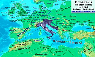
| Aprašymas | Odoacer's Kingdom of Italy in 480 AD. |
| Data | |
| Šaltinis | Mano darbas |
| Autorius | Thomas Lessman (Contact!) |
| Leidimas (Šios rinkmenos panaudojimas kitur) |
Aš, šio darbo autoriaus teisių savininkas, publikuoju jį su šia licencija: Šiam failui taikoma Creative Commons Attribution-Share Alike 3.0 Unported licencija.
|
| Kitos versijos | See Below |
Map Summary[keisti]
Original Source URL: http://www.thomaslessman.com/History/images/East-Hem_480ad.jpg or www.WorldHistoryMaps.info
This map of the Kingdom of Odoacer in 480 AD is a zoomed-in version of Thomas Lessman's map of the East-Hem 480 AD, also available at www.WorldHistoryMaps.info.
The highlighted areas represent Odoacer's Kingdom of Italy, after the capture of Italy (476), conquest of Sicily from the Vandals (477) and the annexation of Dalmatia after the assassination of Emperor Julius Nepos (480).
Map Source References[keisti]
Remember, sources often conflict with each other. This map is only as accurate as the information that is available to me. To report any errors or to help further this work, please click here, or email Thomas Lessman at talessman@yis.us
References for information contained in this map:
Other Maps by Thomas Lessman[keisti]
| Maps of the eastern hemisphere showing history
Bold dates are available on Wikimedia or Wikipedia. | ||
| Primeval | ||
| Ancient
|
·| 600 BC | 550 BC | 527 BC | 500 BC |
400 BC | ·| 1 AD | 50 AD | 100 AD | 200 AD | 300 AD | | |
| Medieval |
·| 500 AD | 565 AD | 600 AD | 700 AD | | |
| Modern |
·| 1500 AD | · * For historical maps of the whole world, | |
Rinkmenos istorija
Paspauskite ant datos/laiko, kad pamatytumėte rinkmeną tokią, kokia ji buvo tuo metu.
| Data/Laikas | Miniatiūra | Matmenys | Naudotojas | Paaiškinimas | |
|---|---|---|---|---|---|
| dabartinis | 19:50, 23 spalio 2022 | | 900 × 545 (701 KiB) | Gyalu22 (aptarimas | indėlis) | Reverted bad faith edit. The Westermanns Atlas doesn't show the Carpi |
| 16:05, 15 rugsėjo 2015 |  | 900 × 545 (727 KiB) | Spiridon Ion Cepleanu (aptarimas | indėlis) | Details about the low-Danube according with H.E.Stier's (dir.) Grosser Atlas zur Weltgeschichte, Westermann 1985. | |
| 21:40, 2 spalio 2008 |  | 900 × 545 (701 KiB) | Talessman (aptarimas | indėlis) | {{Information |Description= |Source= |Date= |Author= |Permission= |other_versions= }} | |
| 10:29, 10 gegužės 2008 |  | 1 402 × 1 023 (380 KiB) | Talessman (aptarimas | indėlis) | {{Information |Description=<big>'''The Odoacer's Kingdom of Italy in 477 AD.'''</big> |Source=Self-made |Author=Thomas Lessman |Permission={{self|cc-by-sa-3.0}} }} |
Jūs negalite perrašyti šios rinkmenos.
Rinkmenos naudojimas
Šie puslapiai naudoja šią rinkmeną:
Visuotinis rinkmenos naudojimas
Ši rinkmena naudojama šiose viki svetainėse:
- Naudojama azb.wikipedia.org
- Naudojama ba.wikipedia.org
- Naudojama bg.wikipedia.org
- Naudojama br.wikipedia.org
- Naudojama ca.wikipedia.org
- Naudojama de.wikipedia.org
- Naudojama el.wikipedia.org
- Naudojama en.wikipedia.org
- Naudojama es.wikipedia.org
- Naudojama eu.wikipedia.org
- Naudojama fi.wikipedia.org
- Naudojama fr.wikipedia.org
- Naudojama fy.wikipedia.org
- Naudojama hy.wikipedia.org
- Naudojama ia.wikipedia.org
- Naudojama it.wikipedia.org
- Naudojama ja.wikipedia.org
- Naudojama ko.wikipedia.org
- Naudojama li.wikipedia.org
- Naudojama lmo.wikipedia.org
- Naudojama lt.wikipedia.org
- Naudojama lv.wikipedia.org
- Naudojama nds.wikipedia.org
- Naudojama nl.wikipedia.org
- Naudojama pl.wikipedia.org
Žiūrėti visuotinį šios rinkmenos naudojimą.
- Maps of regions showing history by year-spans
- Maps of the world showing history
- Maps of the Roman Empire
- Maps of the Byzantine Empire
- Maps of the European Antiquity
- Maps of historical states of Italy
- Maps of 5th-century Africa
- Maps of the Kingdom of Odoacer
- Maps of 5th-century Europe
- Romania in the 5th century
- Maps of the Suebi
- Maps of the Heruli
- Modifications of the history maps by Thomas A. Lessmann
- Maps showing 480