File:Ohio Country en.png
둘러보기로 이동
검색으로 이동
미리 보기 크기: 793 × 599 픽셀 다른 해상도: 318 × 240 픽셀 | 635 × 480 픽셀 | 1,016 × 768 픽셀 | 1,217 × 920 픽셀
원본 파일 (1,217 × 920 픽셀, 파일 크기: 1.41 MB, MIME 종류: image/png)
캡션
설명
이 파일이 나타내는 바에 대한 한 줄 설명을 추가합니다
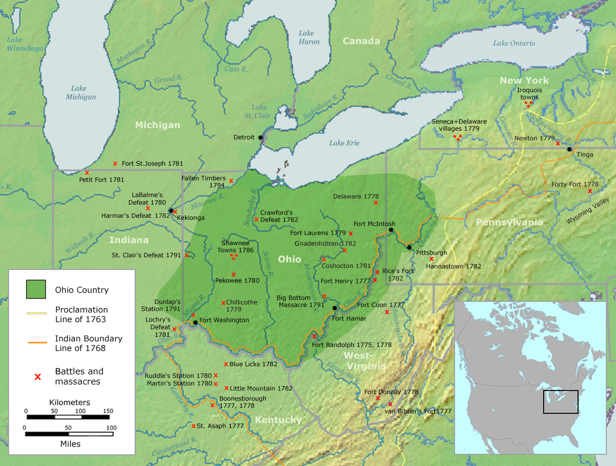
Map of the Ohio Country
| 설명 | Map of the Ohio Country (English version) | ||||
| 날짜 | |||||
| 출처 | Own work by Nikater, submitted to the public domain. Background map courtesy of Demis, www.demis.nl and Wilcomb E. Washburn (Hrsg.) Handbook of North American Indians. Vol. 4: History of Indian-White Relations. Smithsonian Institution Press, Washington D.C. 1988. ISBN 0-16004-583-5 | ||||
| 저자 | User:Nikater | ||||
| 저작권 (이 파일을 인용하기) |
|
||||
| 다른 버전 | Deutsch |
파일 역사
날짜/시간 링크를 클릭하면 해당 시간의 파일을 볼 수 있습니다.
| 날짜/시간 | 섬네일 | 크기 | 사용자 | 설명 | |
|---|---|---|---|---|---|
| 현재 | 2007년 9월 21일 (금) 06:20 | | 1,217 × 920 (1.41 MB) | Nikater (토론 | 기여) | {{Information |Description=Map of the Ohio Country (English version) |Source=Own work by Nikater, submitted to the public domain. Background map courtesy of Demis, www.demis.nl and Wilcomb E. Washburn (Hrsg.) ''Handbook of North American Indians.'' Vol. 4 |
| 2007년 9월 20일 (목) 11:50 |  | 1,217 × 920 (1.41 MB) | Nikater (토론 | 기여) | {{Information |Description=Map of the Ohio Country (English version) |Source=Own work by Nikater, submitted to the public domain. Background map courtesy of Demis, www.demis.nl and Wilcomb E. Washburn (Hrsg.) ''Handbook of North American Indians.'' Vol. 4 | |
| 2007년 9월 17일 (월) 20:21 |  | 1,217 × 920 (1.41 MB) | Nikater (토론 | 기여) | {{Information |Description=Map of the Ohio Country (English version) |Source=Own work by Nikater, submitted to the public domain. Background map courtesy of Demis, www.demis.nl and Wilcomb E. Washburn (Hrsg.) ''Handbook of North American Indians.'' Vol. 4 | |
| 2007년 9월 17일 (월) 20:05 |  | 1,217 × 920 (1.41 MB) | Nikater (토론 | 기여) | {{Information |Description=Map of the Ohio Country (English version) |Source=Own work by Nikater, submitted to the public domain. Background map courtesy of Demis, www.demis.nl and Wilcomb E. Washburn (Hrsg.) ''Handbook of North American Indians.'' Vol. 4 |
이 파일을 덮어쓸 수 없습니다.
이 파일을 사용하는 문서
다음 문서 1개가 이 파일을 사용하고 있습니다:
이 파일을 사용하고 있는 모든 위키의 문서 목록
다음 위키에서 이 파일을 사용하고 있습니다:
- ar.wikipedia.org에서 이 파일을 사용하고 있는 문서 목록
- arz.wikipedia.org에서 이 파일을 사용하고 있는 문서 목록
- ast.wikipedia.org에서 이 파일을 사용하고 있는 문서 목록
- bn.wikipedia.org에서 이 파일을 사용하고 있는 문서 목록
- ca.wikipedia.org에서 이 파일을 사용하고 있는 문서 목록
- cs.wikipedia.org에서 이 파일을 사용하고 있는 문서 목록
- en.wikipedia.org에서 이 파일을 사용하고 있는 문서 목록
- es.wikipedia.org에서 이 파일을 사용하고 있는 문서 목록
- fr.wikipedia.org에서 이 파일을 사용하고 있는 문서 목록
- gl.wikipedia.org에서 이 파일을 사용하고 있는 문서 목록
- id.wikipedia.org에서 이 파일을 사용하고 있는 문서 목록
- ja.wikipedia.org에서 이 파일을 사용하고 있는 문서 목록
- ko.wikipedia.org에서 이 파일을 사용하고 있는 문서 목록
- ms.wikipedia.org에서 이 파일을 사용하고 있는 문서 목록
- no.wikipedia.org에서 이 파일을 사용하고 있는 문서 목록
- pl.wikipedia.org에서 이 파일을 사용하고 있는 문서 목록
- ro.wikipedia.org에서 이 파일을 사용하고 있는 문서 목록
- ru.wikipedia.org에서 이 파일을 사용하고 있는 문서 목록
- so.wikipedia.org에서 이 파일을 사용하고 있는 문서 목록
- sq.wikipedia.org에서 이 파일을 사용하고 있는 문서 목록
- sv.wikipedia.org에서 이 파일을 사용하고 있는 문서 목록
- tr.wikipedia.org에서 이 파일을 사용하고 있는 문서 목록
- www.wikidata.org에서 이 파일을 사용하고 있는 문서 목록
분류:
- Maps of the history of the United States
- Maps of Native American tribal territories
- Battles involving Native Americans in the 18th century
- Ohio Country
- Handbook of North American Indians
- History of indigenous peoples of the Great Lakes Region
- Battles in Ohio
- Battles in Indiana
- Battles in Michigan
- Battles in Pennsylvania
- Battles in New York (state)
- Battles in Kentucky
- Battles in West Virginia
- Maps of the Northwest Indian War
- Kekionga
- Munsee
- Hannastown, Pennsylvania
- Maps of the history of Ohio
- Maps of the history of Indiana
- Maps of the history of Kentucky
- 18th-century maps of the United States