File:Oklahoma topographic map-en.svg
Jump to navigation
Jump to search

Size of this PNG preview of this SVG file: 800 × 405 pixels. Other resolutions: 320 × 162 pixels | 640 × 324 pixels | 1,024 × 518 pixels | 1,280 × 648 pixels | 2,560 × 1,296 pixels | 3,952 × 2,000 pixels.
Original file (SVG file, nominally 3,952 × 2,000 pixels, file size: 14.9 MB)
Captions
Captions
Add a one-line explanation of what this file represents
Summary[edit]
| Description |
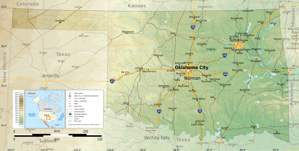
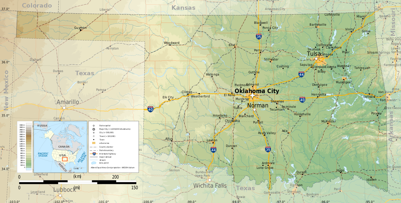
English: Topographic map of Oklahoma
Albers Equal-Area Conic projection, WGS84 datum Geographic limits of the map:
|
| Date | |
| Source |
Own work
|
| Author | Ikonact |

|
This SVG file contains embedded text that can be translated into your language, using any capable SVG editor, text editor or the SVG Translate tool. For more information see: About translating SVG files. |
Licensing[edit]
I, the copyright holder of this work, hereby publish it under the following license:
This file is licensed under the Creative Commons Attribution-Share Alike 4.0 International license.
- You are free:
- to share – to copy, distribute and transmit the work
- to remix – to adapt the work
- Under the following conditions:
- attribution – You must give appropriate credit, provide a link to the license, and indicate if changes were made. You may do so in any reasonable manner, but not in any way that suggests the licensor endorses you or your use.
- share alike – If you remix, transform, or build upon the material, you must distribute your contributions under the same or compatible license as the original.
File history
Click on a date/time to view the file as it appeared at that time.
| Date/Time | Thumbnail | Dimensions | User | Comment | |
|---|---|---|---|---|---|
| current | 23:31, 9 March 2015 | | 3,952 × 2,000 (14.9 MB) | Ikonact (talk | contribs) | =={{int:filedesc}}== {{Information |description={{en|1=Topographic map of en:Oklahoma}} Albers Equal-Area Conic projection, WGS84 datum Geographic limits of the map: *West: 103.2° W *East: 94.2° W *North: 37.2° N *South: 33.4° N |date=2015-03... |
You cannot overwrite this file.
File usage on Commons
More than 100 pages use this file. The following list shows the first 100 pages that use this file only. A full list is available.
- User:Ikonact
- Category:1908 in Oklahoma
- Category:1909 in Oklahoma
- Category:1910 in Oklahoma
- Category:1916 in Oklahoma
- Category:1936 in Oklahoma
- Category:1939 in Oklahoma
- Category:1950 in Oklahoma
- Category:1954 in Oklahoma
- Category:1956 in Oklahoma
- Category:1959 in Oklahoma
- Category:1960 in Oklahoma
- Category:1961 in Oklahoma
- Category:1963 in Oklahoma
- Category:1966 in Oklahoma
- Category:1967 in Oklahoma
- Category:1969 in Oklahoma
- Category:1970 in Oklahoma
- Category:1971 in Oklahoma
- Category:1972 in Oklahoma
- Category:1973 in Oklahoma
- Category:1976 in Oklahoma
- Category:1977 in Oklahoma
- Category:1979 in Oklahoma
- Category:1980 in Oklahoma
- Category:1982 in Oklahoma
- Category:1984 in Oklahoma
- Category:1995 in Oklahoma
- Category:1998 in Oklahoma
- Category:1999 in Oklahoma
- Category:2000 in Oklahoma
- Category:2001 in Oklahoma
- Category:2002 in Oklahoma
- Category:2003 in Oklahoma
- Category:2004 in Oklahoma
- Category:2005 in Oklahoma
- Category:2006 in Oklahoma
- Category:2007 in Oklahoma
- Category:2008 in Oklahoma
- Category:2009 in Oklahoma
- Category:2010 in Oklahoma
- Category:2011 in Oklahoma
- Category:2012 in Oklahoma
- Category:2013 in Oklahoma
- Category:Airports in Oklahoma
- Category:Archaeological sites in Oklahoma
- Category:Basketball players from Oklahoma
- Category:Bodies of water in Oklahoma
- Category:Bridges in Oklahoma
- Category:Cemeteries in Oklahoma
- Category:Cities in Oklahoma
- Category:County seats in Oklahoma
- Category:Culture of Oklahoma
- Category:Dams in Oklahoma
- Category:Education in Oklahoma
- Category:Energy in Oklahoma
- Category:Events in Oklahoma
- Category:Festivals in Oklahoma
- Category:Flora of Oklahoma
- Category:Fountains in Oklahoma
- Category:Gas stations in Oklahoma
- Category:Lakes of Oklahoma
- Category:Libraries in Oklahoma
- Category:Maps of Oklahoma
- Category:Metropolitan areas of Oklahoma
- Category:Mountains of Oklahoma
- Category:Nature reserves in Oklahoma
- Category:Oklahoma
- Category:Oklahoma by decade
- Category:Oklahoma by year
- Category:Oklahoma in the 1900s
- Category:Oklahoma in the 1910s
- Category:Oklahoma in the 1920s
- Category:Oklahoma in the 1930s
- Category:Oklahoma in the 1940s
- Category:Oklahoma in the 1950s
- Category:Oklahoma in the 1960s
- Category:Oklahoma in the 1970s
- Category:Oklahoma in the 1980s
- Category:Oklahoma in the 1990s
- Category:Oklahoma in the 19th century
- Category:Oklahoma in the 2000s
- Category:Oklahoma in the 2010s
- Category:Oklahoma in the 20th century
- Category:Oklahoma in the 21st century
- Category:Organizations in Oklahoma
- Category:Parks in Oklahoma
- Category:Populated places in Oklahoma
- Category:Power plants in Oklahoma
- Category:Protected areas of Oklahoma
- Category:Railway bridges in Oklahoma
- Category:Religion in Oklahoma
- Category:Reservoirs in Oklahoma
- Category:Rivers of Oklahoma
- Category:Roads in Oklahoma
- Category:Schools in Oklahoma
- Category:Towers in Oklahoma
- Category:Towns in Oklahoma
- Category:Unincorporated communities in Oklahoma
- Category:Visitor attractions in Oklahoma
View more links to this file.
File usage on other wikis
The following other wikis use this file:
- Usage on ang.wikipedia.org
- Usage on az.wikipedia.org
- Usage on be.wikipedia.org
- Usage on bg.wikipedia.org
- Usage on ca.wikipedia.org
- Usage on en.wikipedia.org
- Usage on ga.wikipedia.org
- Usage on gl.wikipedia.org
- Usage on hu.wikipedia.org
- Usage on hy.wikipedia.org
- Usage on mhr.wikipedia.org
- Usage on os.wikipedia.org
- Usage on tg.wikipedia.org
- Usage on tt.wikipedia.org
- Usage on www.wikidata.org