File:Oxbow Bend outlook in the Grand Teton National Park.jpg
둘러보기로 이동
검색으로 이동
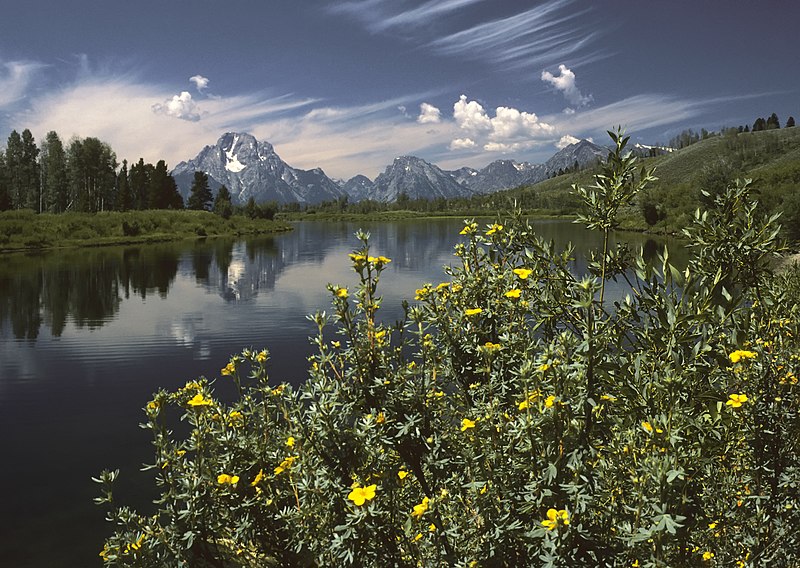
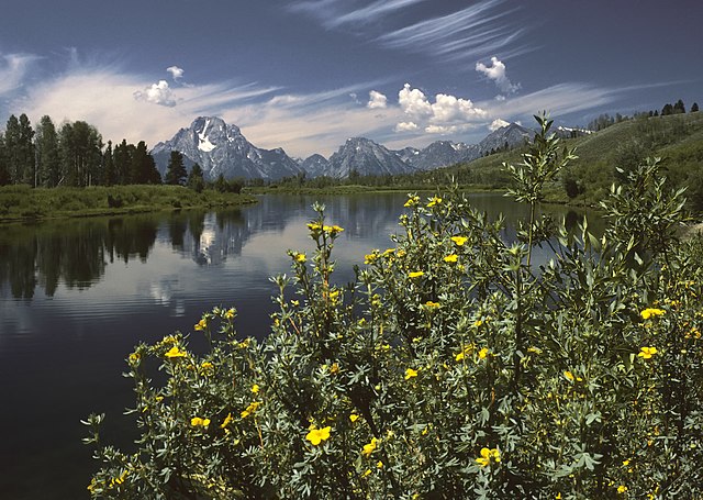
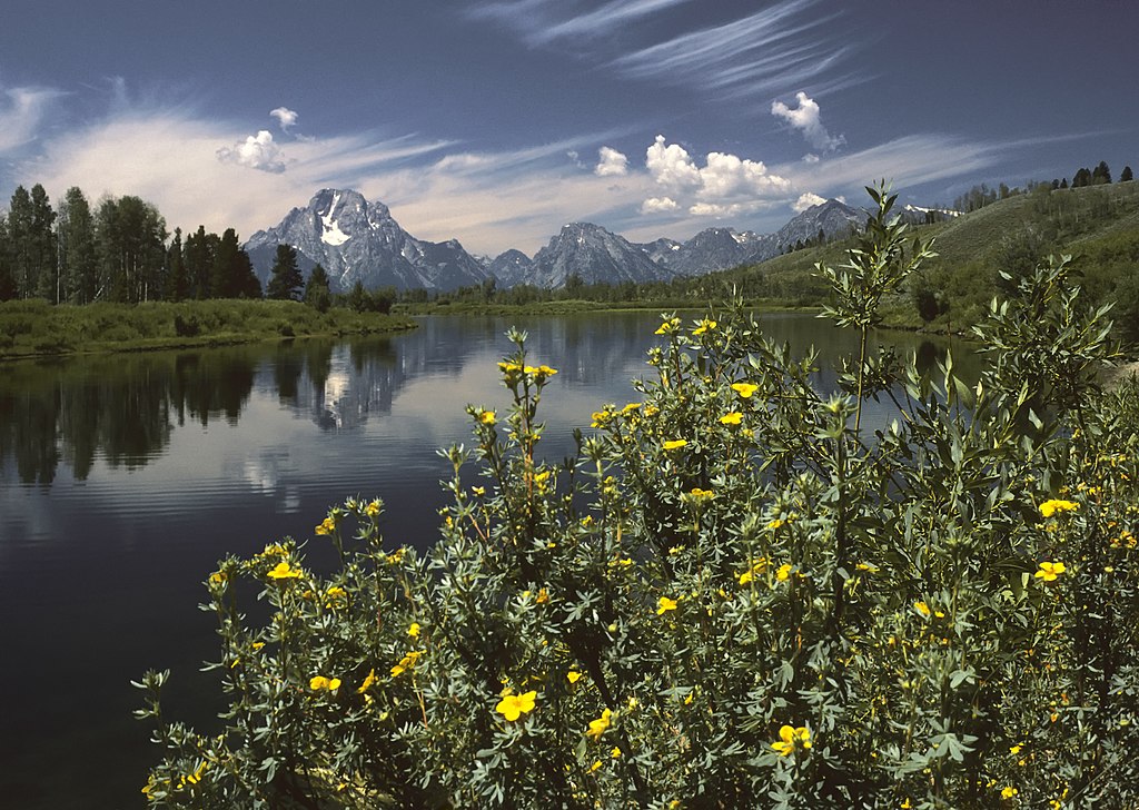
미리 보기 크기: 800 × 568 픽셀 다른 해상도: 320 × 227 픽셀 | 640 × 455 픽셀 | 1,024 × 728 픽셀 | 1,280 × 910 픽셀 | 1,890 × 1,343 픽셀
원본 파일 (1,890 × 1,343 픽셀, 파일 크기: 1.74 MB, MIME 종류: image/jpeg)
캡션
설명
이 파일이 나타내는 바에 대한 한 줄 설명을 추가합니다
파일 설명
[편집]| 설명 |
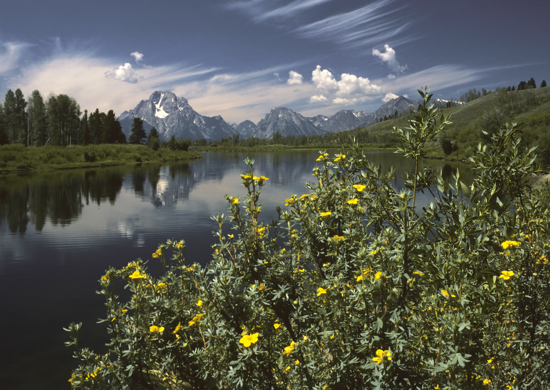
English: Oxbow Bend outlook in the Grand Teton National Park. View over the Snake River to the Mount Moran with the Skillet Glacier (12,605 ft/3,842 m), Bivouac Peak (10,825 ft/3,299 m) and Eagles Rest Peak (11,258 ft/3,431 m) in the Teton Range, Wyoming, United States.
Deutsch: Der Aussichtspunkt Oxbow Bend im Grand Teton National Park, Wyoming, USA mit dem Blick über den Snake River zu den Gipfeln des Mount Moran (3.842 m mit dem Skillet Glacier), des Bivouac Peak (3.299 m) und des Eagles Rest Peak (3.431 m) in dem Teton Range Gebirge.
Français : Vue Oxbow Bend dans le Parc national de Grand Teton, Wyoming, États-Unis. Vue sur la rivière Snake, le Mont Moran avec le Skillet Glacier, (3 842 m), Bivouac Peak (3 299 m) et Eagles Rest Peak (3 431 m) dans le Teton Range.
Italiano: Un meandro del fiume Snake all'interno del Parco nazionale di Grand Teton, nello stato del Wyoming. Domina lo sfondo il Teton Range - con il Monte Moran (3 842 m) sulla sinistra - una catena delle Montagne Rocciose di formazione piuttosto recente (6-9 Ma) per una regione che conserva alcuni tra i depositi geologici più antichi del pianeta, come alcuni scisti e gneiss risalenti al Precambriano. Nella foto si distinguono anche il ghiacciaio Skillet (3 842 m) sul Monte Moran, e le cime del Bivouac Peak (3 299,5 m) and Eagles Rest Peak (3 431 m). |
| 날짜 | |
| 출처 | 자작 |
| 저자 | Michael Gäbler |
| 다른 버전 |
|

| 카메라 위치 | | 이 지역의 다른 사진을 보기: OpenStreetMap |
|---|
| 카메라 모델 | Olympus OM-1 |
|---|---|
| 필름 | Kodachrome 25 |
| 스캐너 | Nikon Coolscan V ED |
|

이 이미지는 2010년 7월 20일의 오늘의 이미지로 선정되었습니다. 이미지 설명은 다음과 같습니다. 한국어: 그랜드 티턴 국립공원의 우각호(옥스보우 밴드) 전망. 미국 와이오밍 주에 있고, 스네이크 강을 지나 티턴 산맥의 스킬렛 빙하(12,605ft)와 비부악 피크(10,825ft), 이글스 레스트 피크(11,258ft)가 있는 모란 산까지의 전경이다. 다른 언어들:
Čeština: Výhled Oxbow Bend v americkém národním parku Grand Teton; pohled přes řeku Snake směrem k Mount Moran s ledovcem Skillet (3 842 m), Bivouac Peak (3 300 m) a Eagles Rest Peak (3 431 m) Dansk: Udsigtspunktet Oxbow Bend i Grand Teton National Park, USA. Forrest ses Snake River og bagved Mount Moran (3.842 m), Bivouac Peak (3.299 m) og Eagles Rest Peak (3.431 m) i Teton-bjergene.. Deutsch: Der Aussichtspunkt Oxbow Bend im Grand Teton National Park, Wyoming, USA mit dem Blick über den Snake River zu den Gipfeln des Mount Moran (3842 m mit dem Skillet Glacier), des Bivouac Peak (3299 m) und des Eagles Rest Peak (3431 m) in dem Teton Range Gebirge. English: Oxbow Bend outlook in the Grand Teton National Park. View over the Snake River to the Mount Moran with the Skillet Glacier (12605 ft), Bivouac Peak (10825 ft) and Eagles Rest Peak (11258 ft) in the Teton Range, Wyoming, United States. Español: Un meandro del río Snake en el interior del Parque Nacional de Grand Teton, en el estado de Wyoming. Domina el fondo el Teton Range —con el Monte Moran (3842 m) a la izquierda—, una cadena de las Montañas Rocosas. Français : Vue Oxbow Bend dans le Parc national de Grand Teton, Wyoming, États-Unis. Vue sur la rivière Snake, le Mont Moran avec le Skillet Glacier, (3 842 m), Bivouac Peak (3 299 m) et Eagles Rest Peak (3 431 m) dans le Teton Range. Italiano: Un meandro del fiume Snake all'interno del Parco nazionale di Grand Teton, nello stato del Wyoming. Domina lo sfondo il Teton Range - con il Monte Moran (3 842 m) sulla sinistra - una catena delle Montagne Rocciose di formazione piuttosto recente (6-9 Ma) per una regione che conserva alcuni tra i depositi geologici più antichi del pianeta, come alcuni scisti e gneiss risalenti al Precambriano. Nederlands: Gezicht over de Snake River (Snakerivier) en de erachter gelegen berg Mount Moran met de gletsjer Skiller en de bergtoppen Bivouac Peak en Eagles Rest Peak vanaf het uitzichtspunt Oxbow Bend in het Grand Teton National Park in de Amerikaanse staat Wyoming. De bergen vormen onderdeel van het Tetongebergte, een bergketen van de Rocky Mountains. Українська: Краєвид Оксбоу Бенд (Вигин Старорічища) в національному парку Гранд Тітон. За річкою Снейк видно гору Моран з льодовиком Скіллет Глетчер, піки Бівуак і Іглз Рест гірського хребта Тітон, Вайомінг, США. 한국어: 그랜드 티턴 국립공원의 우각호(옥스보우 밴드) 전망. 미국 와이오밍 주에 있고, 스네이크 강을 지나 티턴 산맥의 스킬렛 빙하(12,605ft)와 비부악 피크(10,825ft), 이글스 레스트 피크(11,258ft)가 있는 모란 산까지의 전경이다. 日本語: アメリカ合衆国ワイオミング州のグランド・ティトン国立公園 中文: 美国怀俄明州大蒂顿国家公园风景。 中文(繁體): 美國懷俄明州大蒂頓國家公園風景 |
라이선스
[편집]
I, Michael Gäbler은(는) 아래 작품의 저작권자로서, 해당 저작물을 다음과 같은 라이선스로 배포합니다:
이 파일은 크리에이티브 커먼즈 저작자표시 3.0 Unported 라이선스로 배포됩니다.
저작자표시: I, Michael Gäbler
- 이용자는 다음의 권리를 갖습니다:
- 공유 및 이용 – 저작물의 복제, 배포, 전시, 공연 및 공중송신
- 재창작 – 저작물의 개작, 수정, 2차적저작물 창작
- 다음과 같은 조건을 따라야 합니다:
- 저작자표시 – 적절한 저작자 표시를 제공하고, 라이센스에 대한 링크를 제공하고, 변경사항이 있는지를 표시해야 합니다. 당신은 합리적인 방식으로 표시할 수 있지만, 어떤 방식으로든 사용권 허가자가 당신 또는 당신의 사용을 지지하는 방식으로 표시할 수 없습니다.
파일 역사
날짜/시간 링크를 클릭하면 해당 시간의 파일을 볼 수 있습니다.
| 날짜/시간 | 섬네일 | 크기 | 사용자 | 설명 | |
|---|---|---|---|---|---|
| 현재 | 2009년 12월 20일 (일) 16:05 | | 1,890 × 1,343 (1.74 MB) | Michael Gäbler (토론 | 기여) | {{Information |Description={{en|1=Oxbow Bend outlook in the Grand Teton National Park. View over the Snake River to the Mount Moran with the Skillet Glacier (12605 ft), Bivouac Peak (10825 ft) and Eagles Rest Peak (11258 ft) in the Grand Teton, Wyoming, U |
이 파일을 덮어쓸 수 없습니다.
이 파일을 사용하는 문서
다음 문서 47개가 이 파일을 사용하고 있습니다:
- Grand Teton National Park
- Snake River
- Teton Range
- User:Lupo/iat
- User:Michael Gäbler
- User:Ö/Best/2009
- User talk:Michael Gäbler
- Commons:Featured picture candidates/File:Oxbow Bend outlook in the Grand Teton National Park.jpg
- Commons:Featured picture candidates/Log/December 2009
- Commons:Featured pictures/Places/Natural/United States
- Commons:Featured pictures/chronological/2009-B
- Commons:Picture of the Year/2009/Galleries/2009-B
- Commons:Picture of the Year/2009/Galleries/All
- Commons:Picture of the Year/2009/Galleries/Index/18
- Commons:Picture of the Year/2009/Galleries/Index/Nature views
- Commons:Picture of the Year/2009/Galleries/Nature views
- Commons:Picture of the Year/2009/Galleries/Nature views/3
- Commons:Picture of the Year/2009/Galleries/Table/200912
- Commons:Picture of the Year/2009/R1/File:Oxbow Bend outlook in the Grand Teton National Park.jpg
- Commons:Picture of the Year/2009/Results/R1/ALL/Table
- Commons:Picture of the Year/2009/Results/R1/Nature views
- Commons:Picture of the Year/2009/Results/R1/Nature views/Table
- Commons:Potd/2010-07 (da)
- Commons:Potd/2010-07 (de)
- Commons:Potd/2010-07 (nl)
- Commons:Potd/2010-07 (pt)
- Template:Potd/2010-07
- Template:Potd/2010-07-20
- Template:Potd/2010-07-20 (cs)
- Template:Potd/2010-07-20 (da)
- Template:Potd/2010-07-20 (de)
- Template:Potd/2010-07-20 (en)
- Template:Potd/2010-07-20 (es)
- Template:Potd/2010-07-20 (fr)
- Template:Potd/2010-07-20 (hu)
- Template:Potd/2010-07-20 (it)
- Template:Potd/2010-07-20 (ja)
- Template:Potd/2010-07-20 (ko)
- Template:Potd/2010-07-20 (mk)
- Template:Potd/2010-07-20 (nl)
- Template:Potd/2010-07-20 (pt)
- Template:Potd/2010-07-20 (ru)
- Template:Potd/2010-07-20 (uk)
- Template:Potd/2010-07-20 (zh-hans)
- Template:Potd/2010-07-20 (zh-hant)
- Template:Potd/2010-07/short
- Template:Potd/2010-07 (zh-hans)
이 파일을 사용하고 있는 모든 위키의 문서 목록
다음 위키에서 이 파일을 사용하고 있습니다:
- ar.wikipedia.org에서 이 파일을 사용하고 있는 문서 목록
- azb.wikipedia.org에서 이 파일을 사용하고 있는 문서 목록
- ba.wikipedia.org에서 이 파일을 사용하고 있는 문서 목록
- bn.wikipedia.org에서 이 파일을 사용하고 있는 문서 목록
- ceb.wikipedia.org에서 이 파일을 사용하고 있는 문서 목록
- crh.wikipedia.org에서 이 파일을 사용하고 있는 문서 목록
- cv.wikipedia.org에서 이 파일을 사용하고 있는 문서 목록
- da.wikipedia.org에서 이 파일을 사용하고 있는 문서 목록
- de.wikipedia.org에서 이 파일을 사용하고 있는 문서 목록
- de.wikivoyage.org에서 이 파일을 사용하고 있는 문서 목록
- en.wikipedia.org에서 이 파일을 사용하고 있는 문서 목록
- fa.wikipedia.org에서 이 파일을 사용하고 있는 문서 목록
- پارک ملی گرند تیتون
- ویکیپدیا:نگارههای برگزیده/جاها/طبیعت
- ویکیپدیا:گزیدن نگاره برگزیده/نوامبر-۲۰۱۲
- ویکیپدیا:نگاره روز/مارس ۲۰۱۳
- ویکیپدیا:گزیدن نگاره برگزیده/Oxbow Bend outlook in the Grand Teton National Park.jpg
- الگو:نر/2013-03-14
- الگو:نر محافظت شده/2013-03-14
- درگاه:ایالات متحده آمریکا/نگاره برگزیده
- درگاه:ایالات متحده آمریکا/نگاره برگزیده/۳۵
- بحث کاربر:Magic Wizard/بایگانی ۱
- fr.wikipedia.org에서 이 파일을 사용하고 있는 문서 목록
- he.wikipedia.org에서 이 파일을 사용하고 있는 문서 목록
- hu.wikipedia.org에서 이 파일을 사용하고 있는 문서 목록
- it.wikipedia.org에서 이 파일을 사용하고 있는 문서 목록
- ko.wikipedia.org에서 이 파일을 사용하고 있는 문서 목록
- krc.wikipedia.org에서 이 파일을 사용하고 있는 문서 목록
- lbe.wikipedia.org에서 이 파일을 사용하고 있는 문서 목록
- mg.wikipedia.org에서 이 파일을 사용하고 있는 문서 목록
- mk.wikipedia.org에서 이 파일을 사용하고 있는 문서 목록
- nl.wikipedia.org에서 이 파일을 사용하고 있는 문서 목록
- os.wikipedia.org에서 이 파일을 사용하고 있는 문서 목록
- pl.wikipedia.org에서 이 파일을 사용하고 있는 문서 목록
- pt.wikipedia.org에서 이 파일을 사용하고 있는 문서 목록
- ru.wikipedia.org에서 이 파일을 사용하고 있는 문서 목록
- ru.wikinews.org에서 이 파일을 사용하고 있는 문서 목록
- sah.wikipedia.org에서 이 파일을 사용하고 있는 문서 목록
- sv.wikipedia.org에서 이 파일을 사용하고 있는 문서 목록
이 파일의 더 많은 사용 내역을 봅니다.