File:PIA21465 - North Polar Layers.jpg

File originale (2 880 × 1 800 pixel, dimensione del file: 6,2 MB, tipo MIME: image/jpeg)
Didascalie
Didascalie
Dettagli
[modifica]| Descrizione |
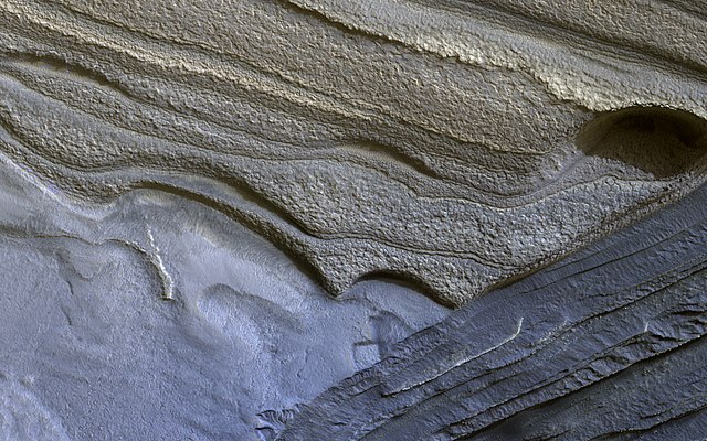
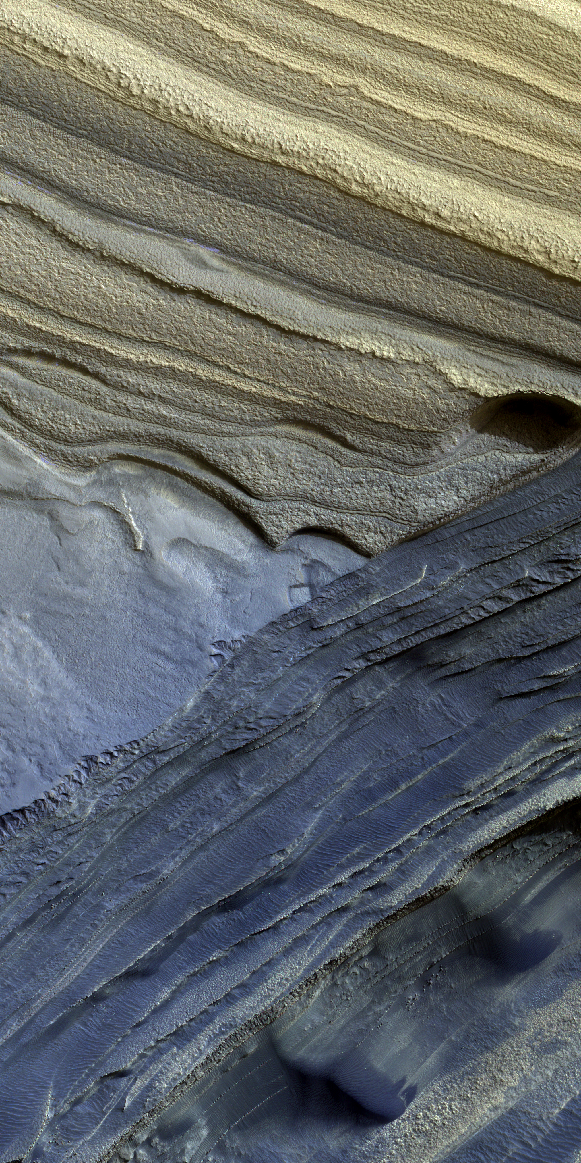
English: The North Polar layered deposits are a 3-kilometer thick stack of dusty water ice layers that are about 1000 kilometers across. The layers record information about climate stretching back a few million years into Martian history.
In many locations erosion has created scarps and troughs that expose this layering. The tan colored layers are the dusty water ice of the polar layered deposits; however a section of bluish layers is visible below them. These bluish layers contain sand-sized rock fragments that likely formed a large polar dunefield before the overlying dusty ice was deposited. The lack of a polar ice cap in this past epoch attests to the variability of the Martian climate, which undergoes larger changes over time than that of the Earth. The map is projected here at a scale of 50 centimeters (19.6 inches) per pixel. [The original image scale is 63.6 centimeters (25 inches) per pixel (with 2 x 2 binning); objects on the order of 191 centimeters (75.2 inches) across are resolved.] North is up. The University of Arizona, Tucson, operates HiRISE, which was built by Ball Aerospace & Technologies Corp., Boulder, Colo. NASA's Jet Propulsion Laboratory, a division of Caltech in Pasadena, California, manages the Mars Reconnaissance Orbiter Project for NASA's Science Mission Directorate, Washington. |
| Data | 18 July 2010 (published 28 February 2017) |
| Fonte | Catalog page · Full-res (JPEG · TIFF) |
| Autore | NASA/JPL-Caltech/Univ. of Arizona |
| Location on Mars | Posizione di questa e altre immagini su: Google Maps |
|---|
Questa immagine o filmato è stato catalogato dal Jet Propulsion Lab della National Aeronautics and Space Administration (NASA) degli Stati Uniti d'Americacon il Photo ID: PIA21465.Questo tag non indica lo status del copyright dell'opera ad esso associato. È quindi richiesto un normale tag di copyright. Vedi Commons:Licenze per maggiori informazioni. Altre lingue:
|
 |
This media is a product of the Mars Reconnaissance Orbiter mission Credit and attribution belongs to the High Resolution Imaging Science Experiment (HiRISE) team, NASA/JPL-Caltech/Univ. of Arizona |
Riconoscimenti
[modifica]
|

![[1]](http://hirise-pds.lpl.arizona.edu/PDS/EXTRAS/RDR/ESP/ORB_018600_018699/ESP_018636_2745/ESP_018636_2745_MIRB.abrowse.jpg)
![[2]](http://hirise-pds.lpl.arizona.edu/PDS/EXTRAS/RDR/ESP/ORB_018600_018699/ESP_018636_2745/ESP_018636_2745_COLOR.abrowse.jpg)
Licenza
[modifica]
| Questo file è nel pubblico dominio perché creato dalla NASA. La politica sul copyright della NASA afferma che «il materiale della NASA non è protetto da copyright a meno che non sia specificato altrimenti». (NASA copyright policy e JPL Image Use Policy). | ||
 |
Attenzione:
|
Cronologia del file
Fare clic su un gruppo data/ora per vedere il file come si presentava nel momento indicato.
| Data/Ora | Miniatura | Dimensioni | Utente | Commento | |
|---|---|---|---|---|---|
| attuale | 08:52, 2 apr 2017 | | 2 880 × 1 800 (6,2 MB) | Gnash (discussione | contributi) | Optimized file size. |
| 13:27, 18 mar 2017 |  | 2 880 × 1 800 (6,66 MB) | Bammesk (discussione | contributi) | larger file (converted from TIFF) | |
| 04:49, 1 mar 2017 |  | 2 880 × 1 800 (866 KB) | PhilipTerryGraham (discussione | contributi) | User created page with UploadWizard |
Impossibile sovrascrivere questo file.
Utilizzo del file
Le seguenti 17 pagine usano questo file:
- User:Hidayatsrf/Gallery
- User:May0721/Featured pictures in the public domain
- User:Nigreco451/FPGallery
- Commons:Featured picture candidates/File:PIA21465 - North Polar Layers.jpg
- Commons:Featured picture candidates/Log/March 2017
- Commons:Featured pictures/Astronomy
- Commons:Featured pictures/chronological/2017-A
- Commons:Picture of the Year/2017/Candidates
- Commons:Picture of the Year/2017/R1/Gallery/2017-A
- Commons:Picture of the Year/2017/R1/Gallery/ALL
- Commons:Picture of the Year/2017/R1/Gallery/Astronomy
- Commons:Picture of the Year/2017/R1/Gallery/M03
- Commons:Picture of the Year/2017/R1/v/PIA21465 - North Polar Layers.jpg
- Commons:Valued image candidates/PIA21465 - North Polar Layers.jpg
- Commons:WikiProject Aviation/recent uploads/2017 April 2
- Commons:WikiProject Aviation/recent uploads/2017 March 1
- Commons:WikiProject Aviation/recent uploads/2017 March 18
Utilizzo globale del file
Anche i seguenti wiki usano questo file:
- Usato nelle seguenti pagine di el.wikipedia.org:
- Usato nelle seguenti pagine di en.wikipedia.org:
- Wikipedia:WikiProject Astronomy/Mars task force
- Wikipedia:Featured pictures/Space/Understanding
- Planum Boreum
- Wikipedia:WikiProject Astronomy/Recognized content
- Climate of Mars
- Portal:Solar System/Selected picture
- Wikipedia:WikiProject Astronomy/Recognized astronomy content
- Wikipedia:WikiProject Astronomy/Mars task force/Recognized content
- Wikipedia:Featured pictures thumbs/61
- Wikipedia:Featured picture candidates/March-2017
- Wikipedia:Wikipedia Signpost/2017-06-09/Featured content
- Wikipedia:Featured picture candidates/Olympia Rupes water ice layers
- Wikipedia:Wikipedia Signpost/Single/2017-06-09
- User:Amakuru/POTD 1
- Wikipedia:Wikipedia Signpost/2018-10-28/Gallery
- Wikipedia:Wikipedia Signpost/Single/2018-10-28
- Wikipedia:Picture of the day/September 2020
- Template:POTD/2020-09-25
- Wikipedia:Main Page history/2020 September 25
- Usato nelle seguenti pagine di fr.wikipedia.org:
- Usato nelle seguenti pagine di hr.wikipedia.org:
- Usato nelle seguenti pagine di it.wikipedia.org:
- Usato nelle seguenti pagine di ro.wikipedia.org:
- Usato nelle seguenti pagine di vi.wikipedia.org: