File:Pan-European corridors.svg
Jump to navigation
Jump to search

Size of this PNG preview of this SVG file: 392 × 486 pixels. Other resolutions: 193 × 240 pixels | 387 × 480 pixels | 619 × 768 pixels | 826 × 1,024 pixels | 1,652 × 2,048 pixels.
Original file (SVG file, nominally 392 × 486 pixels, file size: 561 KB)
Captions
Captions
Add a one-line explanation of what this file represents
Summary[edit]
| Description |
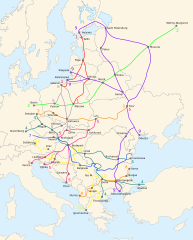
English: Map of the ten Pan-European transport corridors. |
| Date | (UTC) |
| Source | |
| Author |
|
| Other versions |
|
| SVG development |


Licensing[edit]
This file is licensed under the Creative Commons Attribution-Share Alike 3.0 Unported license.
- You are free:
- to share – to copy, distribute and transmit the work
- to remix – to adapt the work
- Under the following conditions:
- attribution – You must give appropriate credit, provide a link to the license, and indicate if changes were made. You may do so in any reasonable manner, but not in any way that suggests the licensor endorses you or your use.
- share alike – If you remix, transform, or build upon the material, you must distribute your contributions under the same or compatible license as the original.
Original upload log[edit]
This image is a derivative work of the following images:
- File:Blank_map_of_Europe_-_Atelier_graphique_colors.svg licensed with Cc-by-sa-2.5,2.0,1.0, Cc-by-sa-2.5,2.0,1.0/en, GFDL, GFDL/en
- 2008-09-23T18:46:08Z Antigoni 841x731 (498781 Bytes) Montenegro update
- 2007-09-16T15:08:27Z Historicair 841x731 (495651 Bytes)
- 2007-09-13T16:36:42Z Historicair 841x731 (495370 Bytes) {{Information |Description={{fr|Carte vierge de l'Europe, couleurs Atelier Graphique}} {{en|Blank map of Europe with Atelier graphique colors}} |Source=[[:Image:Europe countries.svg]] by [[User:Tintazul|Tintazul]] |Date=13/09
- File:Paneuropetransport.png licensed with PD-self, PD-self/en
- 2007-10-18T08:05:36Z Hoshie 773x942 (45202 Bytes) added Montenegro. Under same lic. as before.
- 2006-12-12T23:11:56Z Albinfo 773x942 (37476 Bytes) Fixed several errors and updated corrections in the original file - sorry for all the misleadings
- 2006-12-05T20:06:34Z Geo-Loge 773x941 (33896 Bytes) Ostrava => Brno, Ostrava added, Wroclaw and Krakow added
- 2006-06-24T17:12:35Z Joy 773x941 (28882 Bytes) Fixed confusion between Lviv and Uzhorod.
- 2005-12-30T22:42:00Z Albinfo 773x941 (37167 Bytes) The ten Pan-European transport corridors. Created by [[User:Albinfo]] using [[User:wiki-vr]]'s [[:Image:Europe_blank_map.png|blank map]].
Uploaded with derivativeFX
File history
Click on a date/time to view the file as it appeared at that time.
| Date/Time | Thumbnail | Dimensions | User | Comment | |
|---|---|---|---|---|---|
| current | 21:16, 25 February 2018 | | 392 × 486 (561 KB) | Nameless23 (talk | contribs) | Fixed the spelling of Kaliningrad and Nizhny Novgorod. |
| 23:55, 3 November 2009 |  | 392 × 486 (561 KB) | Joy (talk | contribs) | {{Information |Description={{en|Map of the ten Pan-European transport corridors.}} |Source=*File:Pan-European_corridors.svg |Date=2009-11-03 23:54 (UTC) |Author=*File:Pan-European_corridors.svg: *[[:File:Blank_map_of_Europe_-_Atelier_graphique | |
| 23:46, 3 February 2009 |  | 392 × 486 (554 KB) | Honza.havlicek (talk | contribs) | {{Information |Description={{en|Map of the ten Pan-European transport corridors.}} |Source=*File:Blank_map_of_Europe_-_Atelier_graphique_colors.svg *File:Paneuropetransport.png |Date=2009-02-03 23:39 (UTC) |Author=*[[:File:Blank_map_of_Europe_ |
You cannot overwrite this file.
File usage on Commons
The following 7 pages use this file:
- User:Chumwa/OgreBot/Potential transport maps/2018 February 19-28
- User:Chumwa/OgreBot/Transport Maps/2018 February 19-28
- User:Chumwa/OgreBot/Travel and communication maps/2018 February 19-28
- File:Pan-European corridors de.svg
- File:Pan-European corridors mk.svg
- File:Pan-European corridors ru.svg
- File:Paneuropetransport.png
File usage on other wikis
The following other wikis use this file:
- Usage on ar.wikipedia.org
- Usage on bg.wikipedia.org
- Usage on bs.wikipedia.org
- Usage on en.wikipedia.org
- Usage on fr.wikipedia.org
- Usage on he.wikipedia.org
- Usage on hr.wikipedia.org
- Usage on hu.wikipedia.org
- Usage on id.wikipedia.org
- Usage on it.wikipedia.org
- Usage on ja.wikipedia.org
- Usage on ko.wikipedia.org
- Usage on nl.wikipedia.org
- Usage on no.wikipedia.org
- Usage on pl.wikipedia.org
- Usage on ro.wikipedia.org
- Usage on ru.wikipedia.org
- Usage on sk.wikipedia.org
- Usage on sl.wikipedia.org
- Usage on sq.wikipedia.org
- Usage on uk.wikipedia.org
- Usage on www.wikidata.org