File:Pingualuit aerial 2007.jpg
Từ Wikimedia Commons, kho lưu trữ phương tiện nội dung mở
Bước tới điều hướng
Bước tới tìm kiếm

Kích thước hình xem trước: 800×533 điểm ảnh. Độ phân giải khác: 320×213 điểm ảnh | 640×427 điểm ảnh | 1.024×683 điểm ảnh | 1.280×853 điểm ảnh | 2.560×1.707 điểm ảnh | 6.000×4.000 điểm ảnh.
Tập tin gốc (6.000×4.000 điểm ảnh, kích thước tập tin: 2,32 MB, kiểu MIME: image/jpeg)
Thông tin tập tin
Dữ liệu có cấu trúc
Chú thích
Chú thích
Ghi một dòng giải thích những gì có trong tập tin này
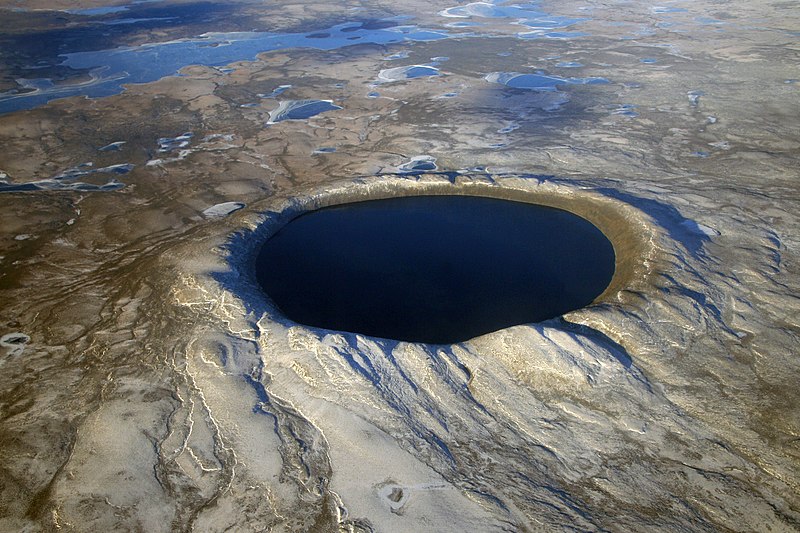
Pingualuit crater in Nunavik, northern Quebec, 2007
Miêu tả[sửa]
| Miêu tảPingualuit aerial 2007.jpg |
English: Pingualuit crater in Nunavik, northern Quebec, Canada, looking west. It contains a lake named Lake Pingualuk.
Français : Le cratère des Pingualuit est un cratère d'impact dans le territoire du Nunavik, Québec, Canada. Le bassin qu'il renferme se nomme lac Pingualuk. |
|||
| Ngày | ||||
| Nguồn gốc | http://earthobservatory.nasa.gov/IOTD/view.php?id=79743&src=eoa-iotd | |||
| Tác giả | NASA. Courtesy of Denis Sarrazin. | |||
| Phiên bản khác |
|
Giấy phép[sửa]
| Public domainPublic domainfalsefalse |
| This file is in the public domain in the United States because it was solely created by NASA. NASA copyright policy states that "NASA material is not protected by copyright unless noted". (See Template:PD-USGov, NASA copyright policy page or JPL Image Use Policy.) |  | |
 |
Warnings:
|
Lịch sử tập tin
Nhấn vào ngày/giờ để xem nội dung tập tin tại thời điểm đó.
| Ngày/Giờ | Hình xem trước | Kích cỡ | Thành viên | Miêu tả | |
|---|---|---|---|---|---|
| hiện tại | 04:31, ngày 14 tháng 12 năm 2012 |  | 6.000×4.000 (2,32 MB) | Tillman (thảo luận | đóng góp) | {{Information |Description ={{en|1=Pingualuit crater, looking southeast}} |Source =http://earthobservatory.nasa.gov/IOTD/view.php?id=79743&src=eoa-iotd |Author =NASA |Date =October 12, 2007 |Permission ={{PD-USGov-NASA... |
Bạn không được phép ghi đè tập tin này.
Trang sử dụng tập tin
3 trang sau sử dụng tập tin này:
Sử dụng tập tin toàn cục
Những wiki sau đang sử dụng tập tin này:
- Trang sử dụng tại ar.wikipedia.org
- فوهة صدمية
- مدملكات
- فوهات أركنو
- اصطدام (علم الفلك)
- حجر نيزكي
- قصف شديد متأخر
- فوهة فريديفورت
- فوهة تشيكشولوب
- بوابة:علوم الأرض
- بوابة:علوم الأرض/قوالب
- فرضية ألفاريز
- حدود الطباشيري-الباليوجيني
- يوجين ميرل شوميكر
- فوهة بارينجر
- فوهة مركبة
- قالب:فوهات صدمية على الأرض
- بحيرة كاراكول
- ميزات تشوه مستوي
- قائمة الفوهات الصدمية على الأرض
- فوهة الوابر
- تأثير النيزك
- قائمة الفوهات الصدمية في أنتاركتيكا
- ويليام كينيث هارتمان
- روبرت إس. ديتز
- رالف بيلكناب بالدوين
- دانيال بارينجر
- حدث نيازك الأوردوفيشي
- ستيشوفيت
- ليتشاتيليريت
- مؤسسة B612
- جبل الظلمة
- حفرة تينومر
- فوهة أويلول
- Trang sử dụng tại arz.wikipedia.org
- Trang sử dụng tại bg.wikipedia.org
- Trang sử dụng tại ceb.wikipedia.org
- Trang sử dụng tại en.wikipedia.org
Xem thêm các trang toàn cục sử dụng tập tin này.
Đặc tính hình
Tập tin này chứa thông tin bổ sung, có thể được thêm từ máy ảnh kỹ thuật số hoặc máy quét được sử dụng để tạo hoặc số hóa tệp.
Nếu tập tin đã được sửa đổi so với trạng thái ban đầu, một số chi tiết có thể không phản ánh đầy đủ tập tin đã sửa đổi.
| Hãng máy ảnh | Canon |
|---|---|
| Dòng máy ảnh | Canon EOS 30D |
| Tốc độ màn trập | 1/100 giây (0,01) |
| Khẩu độ ống kính | f/8 |
| Độ nhạy sáng (tốc độ ISO) | 100 |
| Ngày giờ sinh dữ liệu | 08:48, ngày 12 tháng 10 năm 2007 |
| Độ dài tiêu cự thấu kính | 28 mm |
| Chiều ngang | 6.000 điểm ảnh |
| Chiều cao | 4.800 điểm ảnh |
| Bit trên mẫu |
|
| Thành phần điểm ảnh | RGB |
| Hướng | Thường |
| Số mẫu trên điểm ảnh | 3 |
| Phân giải theo chiều ngang | 150 điểm/inch |
| Phân giải theo chiều cao | 150 điểm/inch |
| Phần mềm sử dụng | Adobe Photoshop CS6 (Macintosh) |
| Ngày giờ sửa tập tin | 17:09, ngày 27 tháng 11 năm 2012 |
| Định vị Y và C | Đồng vị trí |
| Chế độ phơi sáng | Chế độ phong cảnh (đối với ảnh phong cảnh với phông ở trong tiêu cự) |
| Phiên bản Exif | 2.21 |
| Ngày giờ số hóa | 08:48, ngày 12 tháng 10 năm 2007 |
| Ý nghĩa thành phần |
|
| Tốc độ cửa chớp (APEX) | 6,6438598632812 |
| Độ mở ống kính (APEX) | 6 |
| Độ lệch phơi sáng | 0 |
| Chế độ đo | Lấy mẫu |
| Đèn chớp | Đèn flash không chớp, tắt flash cưỡng ép |
| Phiên bản Flashpix được hỗ trợ | 1 |
| Không gian màu | sRGB |
| Phân giải X trên mặt phẳng tiêu | 3.959,3220338983 |
| Phân giải Y trên mặt phẳng tiêu | 3.959,3220338983 |
| Đơn vị phân giải trên mặt phẳng tiêu | inch |
| Sửa hình thủ công | Thường |
| Chế độ phơi sáng | Phơi sáng tự động |
| Cân bằng trắng | Cân bằng trắng tự động |
| Kiểu chụp cảnh | Chuẩn |
| Ngày sửa siêu dữ liệu lần cuối | 12:09, ngày 27 tháng 11 năm 2012 |
| ID duy nhất của tài liệu gốc | uuid:E05711142CAFDC11812CDB7588C4F473 |
| Tình trạng bản quyền | Cờ bản quyền không được đặt |
| Phiên bản IIM | 2 |
