File:Plan of Roman Castra of Mehadia in Danubius Pannonico-Mysicus 1726 by Marsigli.gif
Jump to navigation
Jump to search
Size of this preview: 615 × 600 pixels. Other resolutions: 246 × 240 pixels | 492 × 480 pixels | 775 × 756 pixels.
Original file (775 × 756 pixels, file size: 17 KB, MIME type: image/gif)
Captions
Captions
Add a one-line explanation of what this file represents
Summary[edit]
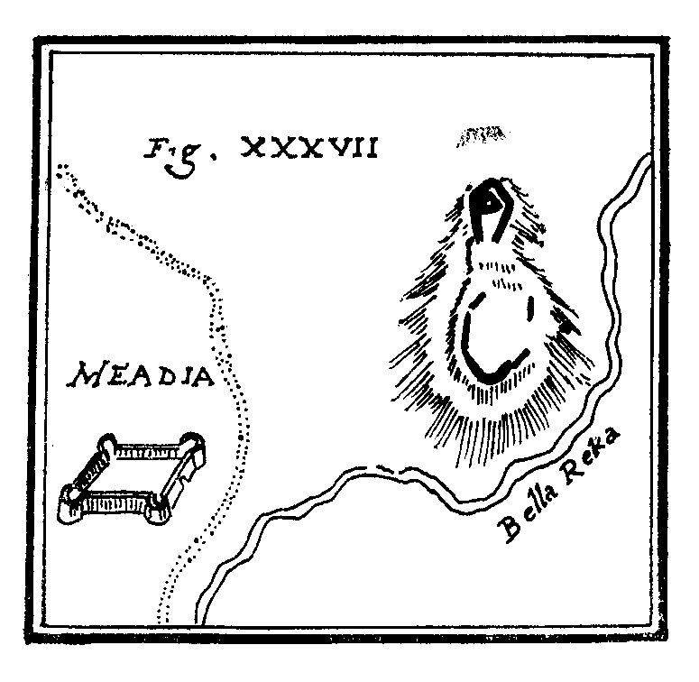
| Luigi Ferdinando Marsigli: Fig. XXXVII
( |
|||||||||||||||||||||||||||
|---|---|---|---|---|---|---|---|---|---|---|---|---|---|---|---|---|---|---|---|---|---|---|---|---|---|---|---|
| Artist |
|
||||||||||||||||||||||||||
| Title |
Fig. XXXVII |
||||||||||||||||||||||||||
| Description |
English: Plan of the Roman Castra of Mehadia (also known as Praetorium), in Mehadia, Romania. Published in the 1726 work Danubius Pannonico-Mysicus, Volume 2 by the Italian naturalist and soldier Luigi Ferdinando Marsigli (1658 – 1730).
This file was uploaded with Commonist.
|
||||||||||||||||||||||||||
| Date | 1726 | ||||||||||||||||||||||||||
| Source/Photographer | Marsigli map from Research history of Praetorium | ||||||||||||||||||||||||||

| Luigi Ferdinando Marsigli: Danubius Pannonico-Mysicus | |||||||||||||||||||||||||||||||||||||||||||||||||||||
|---|---|---|---|---|---|---|---|---|---|---|---|---|---|---|---|---|---|---|---|---|---|---|---|---|---|---|---|---|---|---|---|---|---|---|---|---|---|---|---|---|---|---|---|---|---|---|---|---|---|---|---|---|---|
| Author |
|
 | |||||||||||||||||||||||||||||||||||||||||||||||||||
| Illustrator |
|
||||||||||||||||||||||||||||||||||||||||||||||||||||
| Title | |||||||||||||||||||||||||||||||||||||||||||||||||||||
| Subtitle | Observationibus geographicis, astronomicis, hydrographicis, historicis, physicis perlustratus | ||||||||||||||||||||||||||||||||||||||||||||||||||||
| Volume | 1–6 | ||||||||||||||||||||||||||||||||||||||||||||||||||||
| Publisher | |||||||||||||||||||||||||||||||||||||||||||||||||||||
| Description |
English: 1726 work by the Italian naturalist and soldier Luigi Ferdinando Marsigli (1658 – 1730). It is a natural history encyclopedia of the lower Danube, published in 6 volumes in both The Hague and Amsterdam. The extensive work covers cartography (vol. 1), classical studies (vol. 2), mineralogy (vol. 3), fish fauna (vol. 4), birds (vol. 5) and other subjects (vol. 6).
Detailed information by volumes:
|
||||||||||||||||||||||||||||||||||||||||||||||||||||
| Language | Latin | ||||||||||||||||||||||||||||||||||||||||||||||||||||
| Publication date | 1726 | ||||||||||||||||||||||||||||||||||||||||||||||||||||
| Place of publication | The Hague and Amsterdam | ||||||||||||||||||||||||||||||||||||||||||||||||||||
| Source | Various, see individual images/pages | ||||||||||||||||||||||||||||||||||||||||||||||||||||
| Permission (Reusing this file) |
|
||||||||||||||||||||||||||||||||||||||||||||||||||||

Licensing[edit]
|
This work is in the public domain in its country of origin and other countries and areas where the copyright term is the author's life plus 100 years or fewer. | |
| This file has been identified as being free of known restrictions under copyright law, including all related and neighboring rights. | |
File history
Click on a date/time to view the file as it appeared at that time.
| Date/Time | Thumbnail | Dimensions | User | Comment | |
|---|---|---|---|---|---|
| current | 02:06, 19 December 2011 | | 775 × 756 (17 KB) | Codrinb (talk | contribs) |
You cannot overwrite this file.
File usage on Commons
The following 2 pages use this file:
File usage on other wikis
The following other wikis use this file:
- Usage on de.wikipedia.org
- Usage on en.wikipedia.org
- Usage on ro.wikipedia.org
- Usage on www.wikidata.org