File:Point Lay Alaska DEW Line.jpg
Jump to navigation
Jump to search

Size of this preview: 800 × 530 pixels. Other resolutions: 320 × 212 pixels | 640 × 424 pixels | 1,024 × 679 pixels | 1,280 × 849 pixels | 2,820 × 1,870 pixels.
Original file (2,820 × 1,870 pixels, file size: 1.8 MB, MIME type: image/jpeg)
Captions
Captions
Add a one-line explanation of what this file represents
| Description |
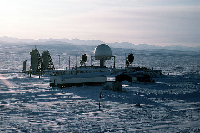
An aerial view of the radar station LIZ-2, one of 30 stations under U.S. Air Force control on the Distant Early Warning (DEW) Line which runs approximately 3,600 miles, from Alaska, across Northern Canada to Greenland. Location: POINT LAY, ALASKA (AK) UNITED STATES OF AMERICA (USA) |
|||
| Date | Taken on 20 February 1987 | |||
| Source | ID:DFST8803446 | |||
| Author |
Service Depicted: Air Force Command Shown: F3203 Camera Operator: TECH. SGT. DONALD L. WETTERMAN |
|||
| Permission (Reusing this file) |
|

| Camera location | | View this and other nearby images on: OpenStreetMap |
|---|
File history
Click on a date/time to view the file as it appeared at that time.
| Date/Time | Thumbnail | Dimensions | User | Comment | |
|---|---|---|---|---|---|
| current | 00:18, 1 December 2006 | | 2,820 × 1,870 (1.8 MB) | Dual Freq (talk | contribs) | {{Information |Source=[http://www.dodmedia.osd.mil/Assets/1988/Air_Force/DF-ST-88-03446.JPEG ID:DFST8803446] |Author=Service Depicted: Air Force</br>Command Shown: F3203</br>Camera Operator: TECH. SGT. DONALD L. WETTERMAN |Description=An aerial view of t |
You cannot overwrite this file.
File usage on Commons
The following page uses this file:
File usage on other wikis
The following other wikis use this file:
- Usage on bg.wikipedia.org
- Usage on bn.wikibooks.org
- Usage on de.wikipedia.org
- Usage on en.wikipedia.org
- Usage on en.wikibooks.org
- Usage on fr.wikipedia.org
- Usage on hy.wikipedia.org
- Usage on it.wikipedia.org
- Usage on pl.wikipedia.org
- Usage on ru.wikipedia.org
- Usage on tr.wikipedia.org
- Usage on uk.wikipedia.org
- Usage on zh.wikipedia.org