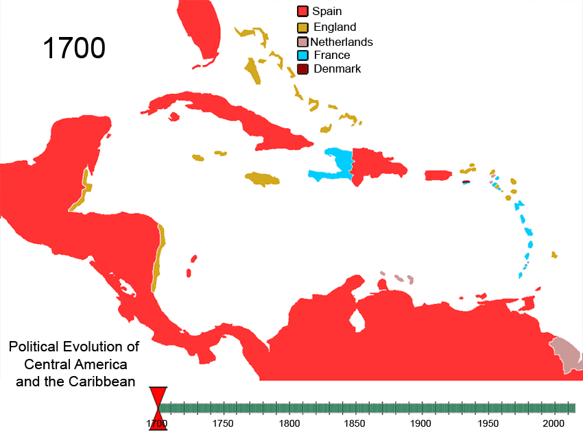
File:Political Evolution of Central America and the Caribbean 1700 and on.gif
Vai alla navigazione
Vai alla ricerca
Dimensioni di questa anteprima: 799 × 600 pixel. Altre risoluzioni: 320 × 240 pixel | 640 × 480 pixel | 850 × 638 pixel.
File originale (850 × 638 pixel, dimensione del file: 348 KB, tipo MIME: image/gif, ciclico, 75 frame, 3 min 3 s)
Didascalie
Didascalie
Aggiungi una brevissima spiegazione di ciò che questo file rappresenta

|
Questa immagine (categorizzazione automatica: historical map) o tutte le immagini in questa categoria o galleria dovrebbero essere ricreate usando grafica vettoriale come file SVG. Questo offre diversi vantaggi: vedi Commons:Media for cleanup per maggiori informazioni. Se è disponibile una versione in formato SVG di questa immagine, per favore caricala. Dopo aver caricato un file SVG, sostituisci questo avviso con il template {{Vector version available|nome_immagine.svg}}.
|
| Caribbean | |||
|---|---|---|---|
| Antigua and Barbuda | |||
| Bahamas | |||
| Barbados | |||
| Belize | |||
| Cuba | |||
| Denmark | |||
| Dominica | |||
| Dominican Republic | |||
| Grenada | |||
| Haiti | |||
| Netherlands | |||
| Jamaica | |||
| Saint Kitts and Nevis | |||
| Saint Lucia | |||
| Saint Vincent and the Grenadines | |||
| Sweden | |||
| Trinidad and Tobago | |||
| United Kingdom | |||
| Spain | |||
| France | |||
| West Indies Federation | |||
| Central America | |||
| Costa Rica | |||
| El Salvador | |||
| Guatemala | |||
| Honduras | |||
| Nicaragua | |||
| Panama | |||
| Spain | |||
| Federal Republic of Central America | |||
| North America | |||
| Viceroyalty of New Spain | |||
| Yucatán (Republic of Yucatan) | |||
| Mexico | |||
| United States of America | |||
| South America | |||
| Viceroyalty of New Granada | |||
| Gran Colombia | |||
| Colombia | |||
| Venezuela | |||
| Guyana | |||
| *Flags used are flags of present day countries or the last flag used by a now-defunct nation. | |||
To recreate this animated gif you can use the following slides:


See Also[modifica]
-
 North America
 -
 Central America
 -
 Balkans
 -
 South America


Italic text
References[modifica]
| Descrizione | Political_Evolution_of_Central_America_and_the_Caribbean_1700_and_on | ||
| Data | |||
| Fonte | Opera propria | ||
| Autore | Esemono | ||
| Licenza (Riusare questo file) |
|
Cronologia del file
Fare clic su un gruppo data/ora per vedere il file come si presentava nel momento indicato.
| Data/Ora | Miniatura | Dimensioni | Utente | Commento | |
|---|---|---|---|---|---|
| attuale | 10:30, 27 feb 2010 | | 850 × 638 (348 KB) | Esemono (discussione | contributi) | Fix dominica occuaption |
| 01:55, 5 mag 2009 |  | 1 000 × 750 (414 KB) | Esemono (discussione | contributi) | Small date error | |
| 00:02, 5 mag 2009 |  | 1 000 × 750 (422 KB) | Esemono (discussione | contributi) | CSA Belize Panama Zone correction USA Netherlands | |
| 03:23, 29 apr 2009 |  | 1 000 × 750 (396 KB) | Esemono (discussione | contributi) | eng to uk | |
| 06:08, 2 apr 2009 |  | 1 000 × 750 (397 KB) | Esemono (discussione | contributi) | Update add panama zone | |
| 11:22, 2 apr 2008 |  | 1 000 × 750 (392 KB) | Esemono (discussione | contributi) | {| align="right" border="0" style="border:1px solid #000000;" |+'''Nations past and present of the Caribbean''' |- ! colspan="4" | '''Caribbean''' |- | bgcolor="cc9933" width="30"| | width="10"| |Antigua and Barbuda |{{flagico |
Impossibile sovrascrivere questo file.
Utilizzo del file
Le seguenti 8 pagine usano questo file:
- Atlas of colonialism
- User:Esemono
- User:Mattes/Favorite files/Images/B
- File:Non-Native-American-Nations-Territorial-Claims-over-NAFTA-countries-1750-2008.gif
- File:Non-Native American Nations Control over N America 1750-2008.gif
- File:Non-Native American Nations Control over South America 1700 and on.gif
- File:Non-Native American Nations Control over South America 1700 and on.ogv
- File:Political Evolution of Central America and the Caribbean 1700 and on.gif
Utilizzo globale del file
Anche i seguenti wiki usano questo file:
- Usato nelle seguenti pagine di af.wikipedia.org:
- Usato nelle seguenti pagine di ar.wikipedia.org:
- Usato nelle seguenti pagine di ast.wikipedia.org:
- Usato nelle seguenti pagine di ba.wikipedia.org:
- Usato nelle seguenti pagine di bg.wikipedia.org:
- Usato nelle seguenti pagine di bn.wikipedia.org:
- Usato nelle seguenti pagine di ca.wikipedia.org:
- Usato nelle seguenti pagine di cs.wikipedia.org:
- Usato nelle seguenti pagine di cv.wikipedia.org:
- Usato nelle seguenti pagine di de.wikipedia.org:
- Usato nelle seguenti pagine di el.wikipedia.org:
- Usato nelle seguenti pagine di en.wikipedia.org:
- History of the Americas
- History of Jamaica
- History of the Caribbean
- History of Central America
- Portal:Caribbean
- List of conflicts in North America
- Portal:Jamaica
- List of land borders with dates of establishment
- Caribbean
- Territorial evolution of the Caribbean
- Talk:Latin America/Archive 3
- Invasion of Jamaica
- Colony of Jamaica
- Usato nelle seguenti pagine di es.wikipedia.org:
- Usato nelle seguenti pagine di eu.wikipedia.org:
- Usato nelle seguenti pagine di fa.wikipedia.org:
- Usato nelle seguenti pagine di fiu-vro.wikipedia.org:
- Usato nelle seguenti pagine di fi.wikipedia.org:
- Usato nelle seguenti pagine di fr.wikipedia.org:
- Usato nelle seguenti pagine di fy.wikipedia.org:
Visualizza l'utilizzo globale di questo file.
Categorie:
- Animated maps of North America
- Animated maps of South America
- Territorial evolution of the Caribbean
- Maps of the history of Central America
- Maps of the history of North America
- Territorial evolution of South America
- Caribbean in the 18th century
- Caribbean in the 19th century
- Central America in the 18th century
- Central America in the 19th century
- North America in the 18th century
- North America in the 19th century
- South America in the 18th century
- South America in the 19th century
- Cuba in the 18th century
- Cuba in the 19th century
- Panama in the 18th century
- Venezuela in the 18th century
- Animated maps showing changing boundaries over time
- Maps of the Viceroyalty of New Spain
- Maps of the Viceroyalty of New Granada