File:Port of Rotterdam Landsat 8 Photo 8 May 2016.jpg
Bước tới điều hướng
Bước tới tìm kiếm

Kích thước hình xem trước: 800×252 điểm ảnh. Độ phân giải khác: 320×101 điểm ảnh | 640×201 điểm ảnh | 1.024×322 điểm ảnh | 1.280×403 điểm ảnh | 5.016×1.578 điểm ảnh.
Tập tin gốc (5.016×1.578 điểm ảnh, kích thước tập tin: 6,73 MB, kiểu MIME: image/jpeg)
Chú thích
Chú thích
Ghi một dòng giải thích những gì có trong tập tin này
Miêu tả
[sửa]
| Miêu tả |
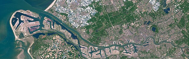
English: Satellite photo of the Port of Rotterdam in South Holland, the Netherlands. This image was captured on May 8, 2016 by the Operational Land Imager (OLI) on the Landsat 8 satellite.
Nederlands: Satellietfoto van de haven van Rotterdam in Zuid-Holland, Nederland. Deze foto is op 8 mei 2016 gemaakt door de Operational Land Imager (OLI) op de Landsat 8 satelliet. |
| Ngày | |
| Nguồn gốc | NASA Earth Observatory - https://earthobservatory.nasa.gov/images/91317/holland-first-stop-for-the-pilgrims |
| Tác giả | NASA Earth Observatory images by Joshua Stevens, using Landsat data from the U.S. Geological Survey. Story by Adam Voiland. |
Giấy phép
[sửa]
| This file is in the public domain in the United States because it was solely created by NASA. NASA copyright policy states that "NASA material is not protected by copyright unless noted". (See Template:PD-USGov, NASA copyright policy page or JPL Image Use Policy.) | ||
 |
Warnings:
|
Lịch sử tập tin
Nhấn vào ngày/giờ để xem nội dung tập tin tại thời điểm đó.
| Ngày/Giờ | Hình xem trước | Kích cỡ | Thành viên | Miêu tả | |
|---|---|---|---|---|---|
| hiện tại | 19:47, ngày 24 tháng 6 năm 2023 | 5.016×1.578 (6,73 MB) | Artanisen (thảo luận | đóng góp) | Uploaded a work by NASA Earth Observatory images by Joshua Stevens, using Landsat data from the U.S. Geological Survey. Story by Adam Voiland. from NASA Earth Observatory - https://earthobservatory.nasa.gov/images/91317/holland-first-stop-for-the-pilgrims with UploadWizard |
Bạn không được phép ghi đè tập tin này.
Trang sử dụng tập tin
9 trang sau sử dụng tập tin này:
- Europoort
- Port of Rotterdam
- Rotterdam
- File:Rotterdam by Sentinel-2, 2018-06-30.jpg
- File:Satellite image of Europoort, Netherlands (4.25E 51.90N).png
- Category:Aker Wayfarer (ship, 2010) in Rotterdam
- Category:Harbour entrance lights in Port of Rotterdam
- Category:Port of Rotterdam
- Category:Shipping containers in Port of Rotterdam
.png)
Sử dụng tập tin toàn cục
Những wiki sau đang sử dụng tập tin này:
- Trang sử dụng tại ar.wikipedia.org
- Trang sử dụng tại ast.wikipedia.org
- Trang sử dụng tại ba.wikipedia.org
- Trang sử dụng tại bn.wikipedia.org
- Trang sử dụng tại ca.wikipedia.org
- Trang sử dụng tại cs.wikipedia.org
- Trang sử dụng tại de.wikipedia.org
- Trang sử dụng tại el.wikipedia.org
- Trang sử dụng tại en.wikipedia.org
- Trang sử dụng tại eo.wikipedia.org
- Trang sử dụng tại es.wikipedia.org
- Trang sử dụng tại eu.wikipedia.org
- Trang sử dụng tại fi.wikipedia.org
- Trang sử dụng tại fr.wikipedia.org
- Trang sử dụng tại he.wikipedia.org
- Trang sử dụng tại hu.wikipedia.org
- Trang sử dụng tại id.wikipedia.org
- Trang sử dụng tại is.wikipedia.org
- Trang sử dụng tại it.wikipedia.org
- Trang sử dụng tại ko.wikipedia.org
- Trang sử dụng tại li.wikipedia.org
- Trang sử dụng tại ms.wikipedia.org
- Trang sử dụng tại nds.wikipedia.org
- Trang sử dụng tại nl.wikipedia.org
- Trang sử dụng tại oc.wikipedia.org
- Trang sử dụng tại pl.wikipedia.org
- Trang sử dụng tại pt.wikipedia.org
Xem thêm các trang toàn cục sử dụng tập tin này.