File:Public transport map of Rio de Janeiro.png
Jump to navigation
Jump to search

Size of this preview: 800 × 547 pixels. Other resolutions: 320 × 219 pixels | 640 × 437 pixels | 1,024 × 700 pixels | 1,280 × 874 pixels | 2,560 × 1,749 pixels | 8,777 × 5,996 pixels.
Original file (8,777 × 5,996 pixels, file size: 15.03 MB, MIME type: image/png)
Captions
Captions
Add a one-line explanation of what this file represents

|
This transport map image could be re-created using vector graphics as an SVG file. This has several advantages; see Commons:Media for cleanup for more information. If an SVG form of this image is available, please upload it and afterwards replace this template with
{{vector version available|new image name}}.
It is recommended to name the SVG file “Public transport map of Rio de Janeiro.svg”—then the template Vector version available (or Vva) does not need the new image name parameter. |
Summary[edit]
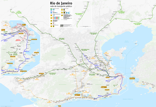
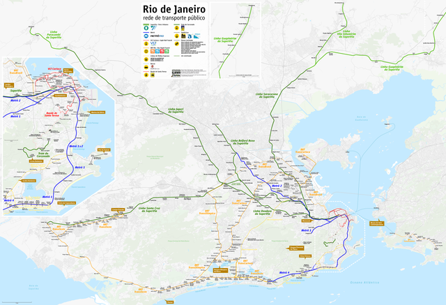
| Description |
Deutsch: Karte ÖPNV Rio de Janeiro
English: Public transport map of Rio de Janeiro
Français : Plan des Transports publics de Rio de Janeiro
Português: Mapa do transporte publico do Rio de Janeiro
Need Assistance! I don't live in Brazil, but I want to make the map as accurate as possible. Informations given in medias and the Web about public transport systems are often incorrect or very inaccurate. So if you want the network map as accurate as possible too, please announce your error hints and corrections about the correct network configuration on my German discussion page. Thank you in advance! |
|||
| Date | see file history | |||
| Source | Own work, using OpenStreetMap data for the background | |||
| Creator | ||||
| Permission (Reusing this file) |
All OpenStreetMap data and maps are Creative Commons "CC-BY-SA 2.0" licensed This file is licensed under the Creative Commons Attribution-Share Alike 2.0 Generic license.
|
|||
| Georeferencing | If inappropriate please set warp_status = skip to hide. | |||
| Other versions |
|


File history
Click on a date/time to view the file as it appeared at that time.
| Date/Time | Thumbnail | Dimensions | User | Comment | |
|---|---|---|---|---|---|
| current | 21:13, 23 November 2018 | | 8,777 × 5,996 (15.03 MB) | Chumwa (talk | contribs) | update, more info |
| 06:08, 24 January 2018 |  | 8,777 × 5,996 (15.03 MB) | Chumwa (talk | contribs) | ||
| 19:11, 12 January 2017 |  | 8,777 × 5,996 (15.03 MB) | Chumwa (talk | contribs) | ||
| 04:29, 13 September 2016 |  | 8,777 × 5,996 (15.02 MB) | Chumwa (talk | contribs) | ||
| 18:28, 5 August 2016 |  | 8,777 × 5,996 (15.02 MB) | Chumwa (talk | contribs) | ||
| 07:46, 17 July 2016 |  | 8,777 × 5,996 (15.04 MB) | Chumwa (talk | contribs) | ||
| 18:52, 2 July 2016 |  | 8,777 × 5,996 (14.98 MB) | Chumwa (talk | contribs) | ||
| 20:41, 26 June 2016 |  | 8,777 × 5,996 (14.98 MB) | Chumwa (talk | contribs) | ||
| 20:25, 20 June 2016 |  | 7,201 × 5,996 (12.34 MB) | Chumwa (talk | contribs) | ||
| 20:42, 19 June 2016 |  | 7,201 × 5,996 (12.34 MB) | Chumwa (talk | contribs) |
You cannot overwrite this file.
File usage on Commons
The following 45 pages use this file:
- Metrô do Rio de Janeiro
- Top 200 transport map images that should use vector graphics
- Transit maps
- User:Chumwa/Gallery
- User:Chumwa/OgreBot/Potential transport maps/2016 August 1-10
- User:Chumwa/OgreBot/Potential transport maps/2016 July 1-10
- User:Chumwa/OgreBot/Potential transport maps/2016 July 11-20
- User:Chumwa/OgreBot/Potential transport maps/2016 June 11-20
- User:Chumwa/OgreBot/Potential transport maps/2016 June 21-30
- User:Chumwa/OgreBot/Potential transport maps/2016 September 11-20
- User:Chumwa/OgreBot/Potential transport maps/2017 January 11-20
- User:Chumwa/OgreBot/Potential transport maps/2018 January 21-31
- User:Chumwa/OgreBot/Potential transport maps/2018 November 21-30
- User:Chumwa/OgreBot/Public transport information/2016 August 1-10
- User:Chumwa/OgreBot/Public transport information/2016 July 1-10
- User:Chumwa/OgreBot/Public transport information/2016 July 11-20
- User:Chumwa/OgreBot/Public transport information/2016 June 11-20
- User:Chumwa/OgreBot/Public transport information/2016 June 21-30
- User:Chumwa/OgreBot/Public transport information/2016 September 11-20
- User:Chumwa/OgreBot/Public transport information/2017 January 11-20
- User:Chumwa/OgreBot/Public transport information/2018 January 21-31
- User:Chumwa/OgreBot/Public transport information/2018 November 21-30
- User:Chumwa/OgreBot/Transport Maps/2016 August 1-10
- User:Chumwa/OgreBot/Transport Maps/2016 July 1-10
- User:Chumwa/OgreBot/Transport Maps/2016 July 11-20
- User:Chumwa/OgreBot/Transport Maps/2016 June 11-20
- User:Chumwa/OgreBot/Transport Maps/2016 June 21-30
- User:Chumwa/OgreBot/Transport Maps/2016 September 11-20
- User:Chumwa/OgreBot/Transport Maps/2017 January 11-20
- User:Chumwa/OgreBot/Transport Maps/2018 January 21-31
- User:Chumwa/OgreBot/Transport Maps/2018 November 21-30
- User:Chumwa/OgreBot/Travel and communication maps/2016 August 1-10
- User:Chumwa/OgreBot/Travel and communication maps/2016 July 1-10
- User:Chumwa/OgreBot/Travel and communication maps/2016 July 11-20
- User:Chumwa/OgreBot/Travel and communication maps/2016 June 11-20
- User:Chumwa/OgreBot/Travel and communication maps/2016 June 21-30
- User:Chumwa/OgreBot/Travel and communication maps/2016 September 11-20
- User:Chumwa/OgreBot/Travel and communication maps/2017 January 11-20
- User:Chumwa/OgreBot/Travel and communication maps/2018 January 21-31
- User:Chumwa/OgreBot/Travel and communication maps/2018 November 21-30
- File:BRT map of Barra da Tijuca.png
- File:Map of the VLT Carioca - Rio de Janeiro Light Rail.png
- File:Public transport map of Rio de Janeiro.png
- Category:Rio de Janeiro Metro
- Category:Rio de Janeiro Metro stations
File usage on other wikis
The following other wikis use this file:
- Usage on ar.wikipedia.org
- Usage on ba.wikipedia.org
- Usage on be-tarask.wikipedia.org
- Usage on bg.wikipedia.org
- Usage on bn.wikipedia.org
- Usage on bs.wikipedia.org
- Usage on da.wikipedia.org
- Usage on de.wikipedia.org
- Usage on en.wikipedia.org
- Usage on en.wikivoyage.org
- Usage on eo.wikipedia.org
- Usage on es.wikipedia.org
- Usage on es.wikivoyage.org
- Usage on eu.wikipedia.org
- Usage on fa.wikipedia.org
- Usage on fi.wikipedia.org
- Usage on fr.wikipedia.org
- Usage on fr.wikivoyage.org
- Usage on he.wikipedia.org
- Usage on he.wikivoyage.org
- Usage on hu.wikipedia.org
- Usage on hy.wikipedia.org
- Usage on hyw.wikipedia.org
- Usage on id.wikipedia.org
- Usage on it.wikipedia.org
- Usage on it.wikivoyage.org
- Usage on ja.wikipedia.org
- Usage on ka.wikipedia.org
- Usage on nl.wikipedia.org
- Usage on nn.wikipedia.org
View more global usage of this file.