File:Pyrenees topographic map-fr.svg

Pradinė rinkmena (SVG rinkmena, formaliai 3 200 × 1 900 taškų, rinkmenos dydis: 6,3 MiB)
Captions
Captions
![]()
Detailed map of large dimension. For a better viewing, click on the link of the image above.
Carte détaillée de grande dimension. Pour une visualisation optimale, cliquer sur le lien de l'image ci-dessus.
Aprašymas[keisti]
| Description |
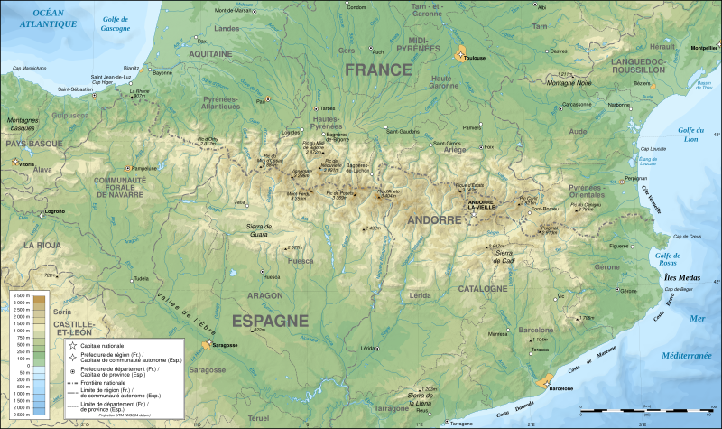
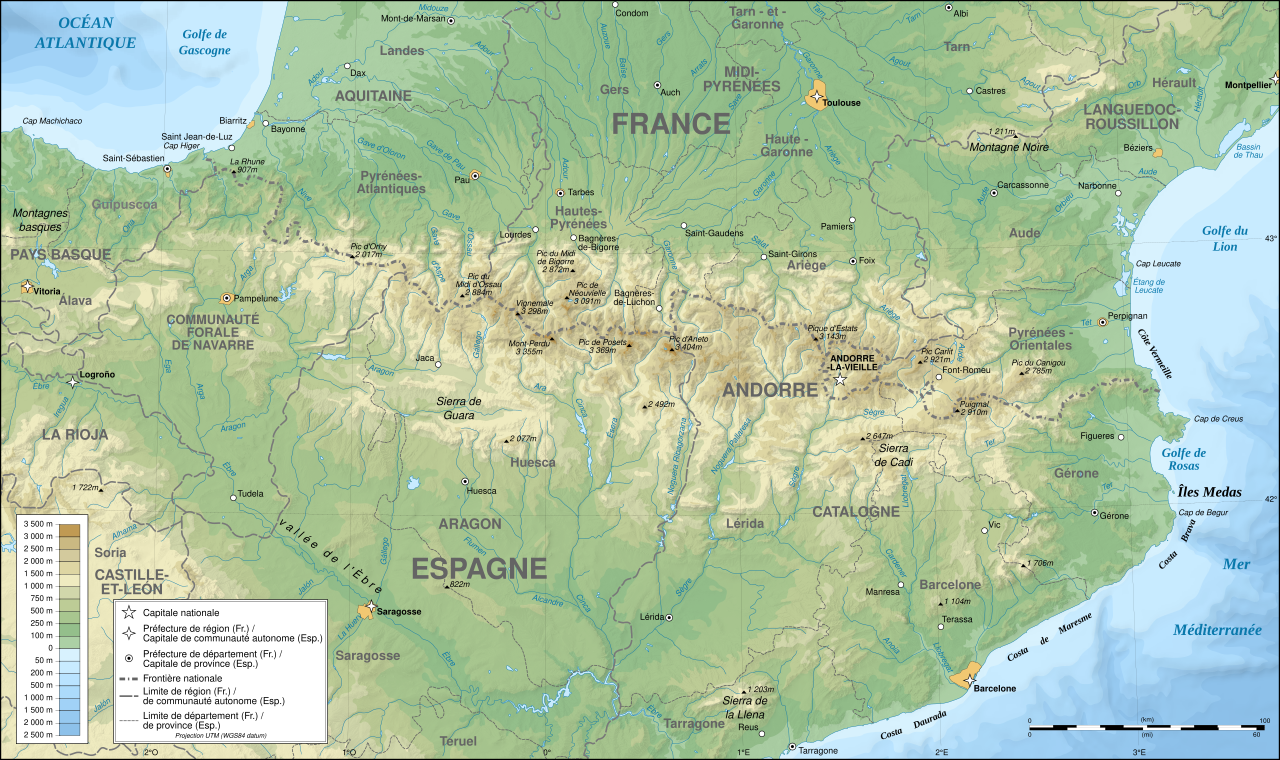
English: Topographic map in French of the Pyrenees mountains.
Note: The shaded relief is a raster image embedded in the SVG file. Français : Carte topographique des Pyrénées en francais.
Note : Le relief ombré est une image bitmap embarquée dans le fichier SVG. Português: Mapa topográfico (em Francês) dos Pirenéus.
Español: Mapa topográfico (en francés) de los Pirineos.
UTM projection; WGS84 datum; shaded relief (composite image of N-W, W and N lightning positions);
|
||
| SVG genesis | |||
| Data | May 2007 (modified September 2008) | ||
| Šaltinis |
Own work;
|
||
| Kūrėjas | |||
| Leidimas (Šios rinkmenos panaudojimas kitur) |
|
||
| Georeferencing | If inappropriate please set warp_status = skip to hide. | ||
| Kitos versijos |
[]
|


Assessment[keisti]
|

Šis paveikslėlis buvo išrinktas dienos paveikslėliu 2007 m. rugpjūčio 1 d.. Jo aprašymas buvo: English: Topographic map in French of the Pyrenees mountains. Kitomis kalbomis:
Čeština: Francouzská mapa pohoří Pyreneje Dansk: Topografisk kort over Pyrenæerne på fransk. English: Topographic map in French of the Pyrenees mountains. Français : Carte topographique des Pyrénées en français. Magyar: A Pireneusok térképe Nederlands: Franse Topografische kaart van de Pyreneeën Português: Um mapa topográfico em francês, da região dos Pireneus. Română: Hartă topografică a munților Pirinei, Franța. Suomi: Topografinen kartta Ranskasta, Pyreneiden vuorilta. Svenska: Topografisk karta över Pyrenéerna på franska. Русский: Топографическая карта Пиренеев. Українська: Топографічна карта Піренеїв 中文: 法语注释的比利牛斯山地形图 中文(繁體): 庇里牛斯山的法語地形圖 עברית : מפה טופוגרפית בצרפתית של הרי הפירינאים |
Licencija[keisti]

|
Suteikiamas leidimas kopijuoti, platinti ir/ar redaguoti šį dokumentą pagal GNU Free Documentation licencijos versijos 1.2 ar bet kurios vėlesnės versijos sąlygas, publikuotas Free Software Foundation; be nekintamų dalių, be priekinių ir galinių tekstinių žymų viršeliuose. Šios licencijos kopija įtraukta dalyje, pavadintoje GNU Free Documentation License. |
| Šiam failui taikoma Creative Commons Attribution-Share Alike 3.0 Unported licencija. | ||
| ||
| Licencijos šablonas buvo priskirtas šiam failui kaip GFDL licencijos atnaujinimo dalis. |
- Jūs galite:
- dalintis – kopijuoti, platinti bei persiųsti šį darbą
- pri(si)taikyti – adaptuoti darbą
- Su šiomis sąlygomis:
- autoriaus nurodymas – Turite pateikti atitinkamą kreditą, pateikti nuorodą į licenciją ir nurodyti, ar buvo atlikti pakeitimai. Tai galite padaryti bet kokiu būdu, bet ne taip, kad licencijos išdavėjas patvirtintų jus ar jūsų naudojimą.
- dalinkis panašiai – Jei perdirbsite, redaguosite ar atkursite šį darbą, jį galėsite platinti tik su tokia pačia ar panašia į šią licencija.
Rinkmenos istorija
Paspauskite ant datos/laiko, kad pamatytumėte rinkmeną tokią, kokia ji buvo tuo metu.
| Data/Laikas | Miniatiūra | Matmenys | Naudotojas | Paaiškinimas | |
|---|---|---|---|---|---|
| dabartinis | 00:05, 14 gruodžio 2012 | | 3 200 × 1 900 (6,3 MiB) | Benh (aptarimas | indėlis) | uses Helvetica over Arial when available. |
| 15:49, 23 rugsėjo 2008 |  | 3 200 × 1 900 (6,3 MiB) | Sting (aptarimas | indėlis) | Using ETOPO1 data for bathymetry; new standard colors | |
| 00:25, 2 liepos 2007 |  | 3 200 × 1 900 (5,9 MiB) | Sting (aptarimas | indėlis) | + projection info in key ; + major cities areas ; some corrections in the rivers | |
| 20:30, 25 birželio 2007 |  | 3 200 × 1 900 (5,88 MiB) | Sting (aptarimas | indėlis) | + key for borders | |
| 21:18, 31 gegužės 2007 |  | 3 200 × 1 900 (5,88 MiB) | Sting (aptarimas | indėlis) | Some corrections | |
| 18:23, 30 gegužės 2007 |  | 3 200 × 1 900 (5,88 MiB) | Sting (aptarimas | indėlis) | {{Information |Description=Topographic map in French of the Pyrenees mountains |Source=Own work ;<br/>Topographic map : [http://www2.jpl.nasa.gov/srtm NASA Shuttle Radar Topography Mission] (SRTM3 v.2) (public domain) edited with [http:// |
Jūs negalite perrašyti šios rinkmenos.
Rinkmenos naudojimas
Šie puslapiai naudoja šią rinkmeną:
- Pyrenees
- User:Bryan/POTY2007-alt
- User:Giorgi Balakhadze/Gallery
- User:JoKalliauer/SVG test suites/Featured details
- User:Pfctdayelise/POTY07 categories/2007 list
- User:Pfctdayelise/POTY07 categories/Diagrams, coats of arms, art and illustrations
- User:Scratchinghead
- User:Sting/Gallery: Regional maps
- User talk:Ayack/Archives 1
- User talk:Sting/Archive 01
- Commons:Bistro/archives/juin 2007
- Commons:Featured picture candidates/File:Settlement map of the Greek tribes before the start of the Peloponnesian War-ru.png
- Commons:Featured picture candidates/Image:Pyrenees topographic map-fr.svg
- Commons:Featured picture candidates/Log/July 2007
- Commons:Featured picture candidates/Log/September 2022
- Commons:Featured pictures/Non-photographic media/Maps
- Commons:Featured pictures/chronological/2007-B
- Commons:Picture of the Year/2007/Galleries/All
- Commons:Picture of the Year/2007/Galleries/Graphic art and maps
- Commons:Picture of the Year/2007/Results/Round 1/Gallery
- Commons:Potd/2007-08 (de)
- Commons:Potd/2007-08 (eo)
- Commons:Potd/2007-08 (fr)
- Commons:Potd/2007-08 (nl)
- Commons:Potd/2007-08 (pl)
- Commons:Potd/2007-08 (pt)
- Commons:Potd/2007-08 (ro)
- Commons:Potd/2007-08 (ru)
- Commons:Potd/2007-08 (tr)
- Commons:Potd/2007-08 (uk)
- Commons:Potd/2007-08 (zh-hant)
- File:218 AC - Iter Gnaei Scipionis in Hispania.png
- File:49 AC - Iter Caesaris in Hispania.png
- File:Pyrenees map shaded relief-fr.svg
- File:Pyrenees relief map with rivers-fr.svg
- File:Pyrenees topo map-blank.jpg
- File:Pyrenees topographic map-ca.svg
- File:Pyrenees topographic map-de.svg
- File:Pyrenees topographic map-en.svg
- File:Pyrenees topographic map-eo.svg
- File:Pyrenees topographic map-es.svg
- File:Pyrenees topographic map-fr.svg
- File:Pyrenees topographic map-it.svg
- File:Pyrenees topographic map-mk.svg
- File:Pyrenees topographic map-pl.svg
- File:Pyrenees topographic map-ru.svg
- Template:Other versions/Pyrenees topographic map
- Template:Potd/2007-08
- Template:Potd/2007-08-01
- Template:Potd/2007-08-01 (ar)
- Template:Potd/2007-08-01 (ast)
- Template:Potd/2007-08-01 (be)
- Template:Potd/2007-08-01 (cs)
- Template:Potd/2007-08-01 (da)
- Template:Potd/2007-08-01 (de)
- Template:Potd/2007-08-01 (en)
- Template:Potd/2007-08-01 (es)
- Template:Potd/2007-08-01 (fi)
- Template:Potd/2007-08-01 (fr)
- Template:Potd/2007-08-01 (he)
- Template:Potd/2007-08-01 (hu)
- Template:Potd/2007-08-01 (is)
- Template:Potd/2007-08-01 (it)
- Template:Potd/2007-08-01 (ja)
- Template:Potd/2007-08-01 (ko)
- Template:Potd/2007-08-01 (nl)
- Template:Potd/2007-08-01 (pam)
- Template:Potd/2007-08-01 (pl)
- Template:Potd/2007-08-01 (pt)
- Template:Potd/2007-08-01 (ro)
- Template:Potd/2007-08-01 (ru)
- Template:Potd/2007-08-01 (sv)
- Template:Potd/2007-08-01 (uk)
- Template:Potd/2007-08-01 (zh-hans)
- Template:Potd/2007-08-01 (zh-hant)
- Template:Potd/2007-08 (zh-hans)
- Category:Borders of France-Spain
- Category:Pyrenees
Visuotinis rinkmenos naudojimas
Ši rinkmena naudojama šiose viki svetainėse:
- Naudojama af.wikipedia.org
- Naudojama an.wikipedia.org
- Naudojama ar.wikipedia.org
- Naudojama azb.wikipedia.org
- Naudojama ba.wikipedia.org
- Naudojama bs.wikipedia.org
- Naudojama ca.wikipedia.org
- Naudojama cs.wikipedia.org
- Naudojama en.wikipedia.org
- Naudojama eo.wikipedia.org
- Naudojama es.wikipedia.org
- Naudojama et.wikipedia.org
- Naudojama eu.wikipedia.org
- Naudojama fa.wikipedia.org
- Naudojama fi.wikipedia.org
- Naudojama fr.wikipedia.org
- Ariège (département)
- Aude (département)
- Andorre
- Sentier de grande randonnée 10
- Haute-Garonne
- Hautes-Pyrénées
- Pyrénées-Orientales
- Pyrénées
- Liste des communes des Hautes-Pyrénées
- Discussion:Liste des communes des Hautes-Pyrénées
- Pau
- Béarn
- Bayonne
- Tarbes
- Adour
- Ariège (rivière)
- Vals (Ariège)
- Catalogne
- Aragon (communauté autonome)
- Huesca
- Bizanos
- Pays basque
- Discussion:Béarn
- Discussion:Pau
- Val d'Aran
- Prades (Pyrénées-Orientales)
- Haute-Navarre
- Lugdunum Convenarum
- Lourdes
Žiūrėti visuotinį šios rinkmenos naudojimą.