File:Quebec province topographic map-fr.svg
둘러보기로 이동
검색으로 이동

SVG 파일의 PNG 형식의 미리보기 크기: 484 × 600 픽셀. 다른 해상도: 194 × 240 픽셀 | 387 × 480 픽셀 | 620 × 768 픽셀 | 826 × 1,024 픽셀 | 1,652 × 2,048 픽셀 | 1,261 × 1,563 픽셀
원본 파일 (SVG 파일, 실제 크기 1,261 × 1,563 픽셀, 파일 크기: 956 KB)
캡션
설명
이 파일이 나타내는 바에 대한 한 줄 설명을 추가합니다
이 이미지는 2009년 11월 25일의 오늘의 이미지로 선정되었습니다. 이미지 설명은 다음과 같습니다. 다른 언어들:
Bosanski: Topografska mapa Kvebeka (Kanada) na francuskom sa gradovima iz popisa 2000. Français : Carte topographique en français du Québec, Canada, avec agglomérations suivant le recensement de 2000. Italiano: Carta topografica in francese della provincia canadese del Québec aggiornata secondo i dati del censimento del 2000. Magyar: A kanadai Québec tartomány francia nyelvű topográfiai térképe a 2000-es népszámlálás szerinti városok feltüntetésével Nederlands: Franstalige topografische kaart van de Canadese (Franssprekende) provincie Québec met de steden van de volkstelling van 2002 Polski: Topograficzna mapa Quebecu (Kanada) w języku francuskim. Português: Mapa topográfico em francês do Quebeque, Canadá, com as cidades do censo de 2000. Македонски: Топографска карта на покраината Квебек, Канада, на француски јазик. Русский: Физическая карта провинции Квебек (Канада) на французском языке. Использованы данные переписи 2000 года. Українська: Фізична карта провінції Квебек, Канада французькою мовою. Наведені дані перепису населення 2000 року. বাংলা : ফরাসী ভাষায় লিখিত কানাডার, কুইবেক অঙ্গরাজ্যের প্রাকৃতিক মানচিত্র। প্রায় ২০০০ শহর উল্লেখিত রয়েছে। 中文: 加拿大魁北克地形学法文地图,根据2000年城市人口普查数据绘制 中文(繁體): 加拿大魁北克地形學法文地圖,根據2000年城市人口普查數據繪製 |
|

파일 설명
[편집]| 카메라 위치 | | 이 지역의 다른 사진을 보기: OpenStreetMap |
|---|
| 설명 |
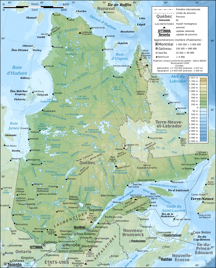
English: Topographic map in French of Quebec, Canada, with 2000' census cities. Note: The background map is a raster image embedded in the SVG file. Français : Carte topographique en français du Québec, Canada, avec agglomérations suivant le recensement de 2000.
Note : Le fond de carte est une image bitmap embarquée dans le fichier SVG.
|
||
| 날짜 | |||
| 출처 |
Own work ;
|
||
| 저자 | Eric Gaba (Sting - fr:Sting) | ||
| 저작권 (이 파일을 인용하기) |
|
||
| 다른 버전 |
[]
Same base map but with topography and without transportation:
Same map, but with an extra layer containing locations of Hydro-Québec's generating stations and 735 kV lines and substations
|


|
이 SVG 파일은 편집 가능한 문자를 사용하므로 Inkscape나 Adobe Illustrator를 사용하여 쉽게 다른 언어로 번역할 수 있습니다. 여기를 참고하세요. 또한 텍스트 편집기를 이용하여 수동으로 파일을 번역할 수도 있습니다. |
라이선스
[편집]
나는 아래 작품의 저작권자로서, 이 저작물을 다음과 같은 라이선스로 배포합니다:

|
GNU 자유 문서 사용 허가서 1.2판 또는 자유 소프트웨어 재단에서 발행한 이후 판의 규정에 따라 본 문서를 복제하거나 개작 및 배포할 수 있습니다. 본 문서에는 변경 불가 부분이 없으며, 앞 표지 구절과 뒷 표지 구절도 없습니다. 본 사용 허가서의 전체 내용은 GNU 자유 문서 사용 허가서 부분에 포함되어 있습니다. |
- 이용자는 다음의 권리를 갖습니다:
- 공유 및 이용 – 저작물의 복제, 배포, 전시, 공연 및 공중송신
- 재창작 – 저작물의 개작, 수정, 2차적저작물 창작
- 다음과 같은 조건을 따라야 합니다:
- 저작자표시 – 적절한 저작자 표시를 제공하고, 라이센스에 대한 링크를 제공하고, 변경사항이 있는지를 표시해야 합니다. 당신은 합리적인 방식으로 표시할 수 있지만, 어떤 방식으로든 사용권 허가자가 당신 또는 당신의 사용을 지지하는 방식으로 표시할 수 없습니다.
- 동일조건변경허락 – 만약 당신이 이 저작물을 리믹스 또는 변형하거나 이 저작물을 기반으로 제작하는 경우, 당신은 당신의 기여물을 원저작물과 동일하거나 호환 가능한 라이선스에 따라 배포하여야 합니다.
이 라이선스 중에서 목적에 맞는 것을 선택하여 사용할 수 있습니다.
파일 역사
날짜/시간 링크를 클릭하면 해당 시간의 파일을 볼 수 있습니다.
| 날짜/시간 | 섬네일 | 크기 | 사용자 | 설명 | |
|---|---|---|---|---|---|
| 현재 | 2009년 3월 3일 (화) 13:43 | | 1,261 × 1,563 (956 KB) | Sting (토론 | 기여) | Correction ; + additional labels |
| 2009년 3월 3일 (화) 00:04 |  | 1,261 × 1,563 (949 KB) | Sting (토론 | 기여) | == Summary == {{Location|54|00|00|N|68|30|00|W|scale:10000000}} <br/> {{Information |Description={{en|Topographic map in French of Quebec, Canada, with 2000' census cities.}} {{fr|Carte topographique en français du [[:fr:Qu� |
이 파일을 덮어쓸 수 없습니다.
이 파일을 사용하는 문서
다음 문서 61개가 이 파일을 사용하고 있습니다:
- User:Giorgi Balakhadze/Gallery
- User:JoKalliauer/SVG test suites/Featured details
- User:Sting/Gallery: Regional maps
- User:Ö/Best/2009
- User talk:Sting/Archive 01
- Commons:Featured picture candidates/File:Quebec province topographic map-fr.svg
- Commons:Featured picture candidates/Log/March 2009
- Commons:Featured pictures/Non-photographic media/Maps
- Commons:Featured pictures/chronological/2009-A
- Commons:Picture of the Year/2009/Galleries/2009-A
- Commons:Picture of the Year/2009/Galleries/All
- Commons:Picture of the Year/2009/Galleries/Diagrams
- Commons:Picture of the Year/2009/Galleries/Index/3
- Commons:Picture of the Year/2009/Galleries/Index/Diagrams
- Commons:Picture of the Year/2009/Galleries/Table/200903
- Commons:Picture of the Year/2009/R1/File:Quebec province topographic map-fr.svg
- Commons:Picture of the Year/2009/Results/R1/ALL/Table
- Commons:Picture of the Year/2009/Results/R1/Diagrams
- Commons:Picture of the Year/2009/Results/R1/Diagrams/Table
- Commons:Potd/2009-11 (da)
- Commons:Potd/2009-11 (de)
- Commons:Potd/2009-11 (eo)
- Commons:Potd/2009-11 (nl)
- Commons:Potd/2009-11 (pt)
- Commons:Potd/2009-11 (tr)
- File:Quebec Map with Hydro-Québec infrastructures-en.png
- File:Quebec Map with Hydro-Québec infrastructures-en.svg
- File:Quebec Map with Hydro-Québec infrastructures-fr.png
- File:Quebec Map with Hydro-Québec infrastructures-fr.svg
- File:Quebec province topographic map-blank.svg
- File:Quebec province topographic map-fr.svg
- File:Quebec province topographic map-it.svg
- File:Quebec province topographic map-ru.svg
- File:Quebec province transportation and cities map-fr.jpg
- File:Quebec province transportation and cities map-fr.svg
- File:Sagamie.svg
- File:Vallée de la Matapedia.svg
- Template:Other versions/Quebec province map
- Template:Potd/2009-11
- Template:Potd/2009-11-25
- Template:Potd/2009-11-25 (bn)
- Template:Potd/2009-11-25 (bs)
- Template:Potd/2009-11-25 (cs)
- Template:Potd/2009-11-25 (cy)
- Template:Potd/2009-11-25 (da)
- Template:Potd/2009-11-25 (de)
- Template:Potd/2009-11-25 (en)
- Template:Potd/2009-11-25 (es)
- Template:Potd/2009-11-25 (fr)
- Template:Potd/2009-11-25 (hu)
- Template:Potd/2009-11-25 (it)
- Template:Potd/2009-11-25 (mk)
- Template:Potd/2009-11-25 (nl)
- Template:Potd/2009-11-25 (pam)
- Template:Potd/2009-11-25 (pl)
- Template:Potd/2009-11-25 (pt)
- Template:Potd/2009-11-25 (ru)
- Template:Potd/2009-11-25 (uk)
- Template:Potd/2009-11-25 (zh-hans)
- Template:Potd/2009-11-25 (zh-hant)
- Template:Potd/2009-11 (zh-hans)
이 파일을 사용하고 있는 모든 위키의 문서 목록
다음 위키에서 이 파일을 사용하고 있습니다:
- af.wikipedia.org에서 이 파일을 사용하고 있는 문서 목록
- ba.wikipedia.org에서 이 파일을 사용하고 있는 문서 목록
- bn.wikipedia.org에서 이 파일을 사용하고 있는 문서 목록
- crh.wikipedia.org에서 이 파일을 사용하고 있는 문서 목록
- cs.wikipedia.org에서 이 파일을 사용하고 있는 문서 목록
- cv.wikipedia.org에서 이 파일을 사용하고 있는 문서 목록
- da.wikipedia.org에서 이 파일을 사용하고 있는 문서 목록
- en.wikipedia.org에서 이 파일을 사용하고 있는 문서 목록
- et.wikipedia.org에서 이 파일을 사용하고 있는 문서 목록
- frp.wikipedia.org에서 이 파일을 사용하고 있는 문서 목록
- fr.wikipedia.org에서 이 파일을 사용하고 있는 문서 목록
- Géographie du Québec
- Utilisateur:Sting
- Québec
- Araignées du Québec
- Wikipédia:Image du jour/mars 2009
- Projet:Cartographie/Cartes standards/Pays
- Wikipédia:Atelier graphique/Cartes/Archives/mars 2009
- Wikipédia:Image du jour/29 mars 2009
- Wikipédia:Atelier graphique/Cartes/Archives/juin 2009
- Wikipédia:Atelier graphique/Cartes/Archives/avril 2010
- Wikipédia:Atelier graphique/Cartes/Archives/Demandes mises en sommeil/Europe
- hu.wikipedia.org에서 이 파일을 사용하고 있는 문서 목록
- is.wikipedia.org에서 이 파일을 사용하고 있는 문서 목록
- ko.wikipedia.org에서 이 파일을 사용하고 있는 문서 목록
- krc.wikipedia.org에서 이 파일을 사용하고 있는 문서 목록
- lbe.wikipedia.org에서 이 파일을 사용하고 있는 문서 목록
- lmo.wikipedia.org에서 이 파일을 사용하고 있는 문서 목록
- mk.wikipedia.org에서 이 파일을 사용하고 있는 문서 목록
- nl.wikipedia.org에서 이 파일을 사용하고 있는 문서 목록
- oc.wikipedia.org에서 이 파일을 사용하고 있는 문서 목록
- os.wikipedia.org에서 이 파일을 사용하고 있는 문서 목록
- pam.wikipedia.org에서 이 파일을 사용하고 있는 문서 목록
- pl.wikipedia.org에서 이 파일을 사용하고 있는 문서 목록
- pt.wikipedia.org에서 이 파일을 사용하고 있는 문서 목록
- ru.wikipedia.org에서 이 파일을 사용하고 있는 문서 목록
- ru.wikinews.org에서 이 파일을 사용하고 있는 문서 목록
- sah.wikipedia.org에서 이 파일을 사용하고 있는 문서 목록
- sn.wikipedia.org에서 이 파일을 사용하고 있는 문서 목록
- sv.wikipedia.org에서 이 파일을 사용하고 있는 문서 목록
- uk.wikipedia.org에서 이 파일을 사용하고 있는 문서 목록
이 파일의 더 많은 사용 내역을 봅니다.