File:Rajendra map new.svg

Tập tin gốc (tập tin SVG, 466×333 điểm ảnh trên danh nghĩa, kích thước: 220 kB)
Chú thích
Chú thích
Miêu tả
[sửa]
| Miêu tả |
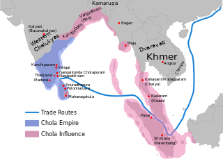
per http://cw.routledge.com/textbooks/9780415485432/15.asp "THE CŌḶAS" by K. A. Nilakanta Sastri and other histories of South Asia consulted.
The file has several changes from the original. The map is corrected to show are of influence and direct control in Sri Lanka. Correction was based on the work of Spencer, G. (1976). The Politics of Plunder: The Cholas in Eleventh-Century Ceylon. The Journal of Asian Studies, 35(3), 405-419. doi:10.2307/2053272. The correction about the Chola influence in Malay areas is based on https://archive.org/details/earlykingdomsofi0000muno/page/118/mode/2up The influence added the area of Lamuri based on Tanjore inscription. Andaman is deleted leaving only Nicobar (information on Tanjore inscription). |
| Ngày | (UTC) |
| Nguồn gốc | |
| Tác giả |
|
| Đây là một ảnh đã được chỉnh sửa, có nghĩa là nó đã được chỉnh sửa kỹ thuật số so với phiên bản gốc. Các chỉnh sửa: Redrew png as svg. Có thể xem phiên bản gốc tại đây: Rajendra map new.png. Các chỉnh sửa được thực hiện bởi Gregors.
|
| Tập tin này được phát hành theo Giấy phép Creative Commons Ghi công - Chia sẻ tương tự 3.0 Chưa chuyển đồi Tuân theo lời phủ nhận. | ||
| ||
| Thẻ quyền này được thêm vào tập tin trong khi cập nhật giấy phép GFDL. |

|
Bạn có quyền sao chép, phân phối và/hoặc sửa đổi tài liệu này theo những điều khoản được quy định trong Giấy phép Tài liệu Tự do GNU, phiên bản 1.2 hoặc các phiên bản mới hơn được Quỹ Phần mềm Tự do; quy định; ngoại trừ những phần không được sửa đổi, bìa trước và bìa sau. Bạn có thể xem giấy phép nói trên ở phần Giấy phép Tài liệu Tự do GNU. |
Nhật trình tải lên đầu tiên
[sửa]
This image is a derivative work of the following images:
- File:Rajendra_map_new.png licensed with Cc-by-sa-3.0-migrated-with-disclaimers, GFDL-en, GFDL-user-en-with-disclaimers
- 2011-03-21T12:16:23Z Gregors 600x429 (102117 Bytes) Bitmap of svg that i will soon upload. ~~~~
- 2009-06-07T09:04:06Z Maukie 629x442 (215021 Bytes) {{Information |Description={{en|Map showing the extent of the [[:en:Chola empire|]] during [[:en:Rajendra Chola I|]] (c. 1030 CE)}} |Source=Transferred from [http://en.wikipedia.org en.wikipedia]; transfer was stated to be ma
Uploaded with derivativeFX
Lịch sử tập tin
Nhấn vào ngày/giờ để xem nội dung tập tin tại thời điểm đó.
| Ngày/Giờ | Hình xem trước | Kích cỡ | Thành viên | Miêu tả | |
|---|---|---|---|---|---|
| hiện tại | 03:54, ngày 24 tháng 5 năm 2024 | | 466×333 (220 kB) | SKAG123 (thảo luận | đóng góp) | Reverted to version as of 15:53, 12 May 2024 (UTC) Vandalism |
| 17:33, ngày 20 tháng 5 năm 2024 |  | 466×333 (189 kB) | Tirukodimadachengunrur (thảo luận | đóng góp) | Reverted to version as of 05:36, 11 May 2024 (UTC) | |
| 15:53, ngày 12 tháng 5 năm 2024 |  | 466×333 (220 kB) | SKAG123 (thảo luận | đóng góp) | Reverted to version as of 16:27, 6 May 2024 (UTC) | |
| 05:36, ngày 11 tháng 5 năm 2024 |  | 466×333 (189 kB) | Ranithraj (thảo luận | đóng góp) | Reverted to version as of 07:21, 1 May 2024 (UTC) | |
| 16:27, ngày 6 tháng 5 năm 2024 |  | 466×333 (220 kB) | Editer1234566 (thảo luận | đóng góp) | Reverted to version as of 21:50, 21 December 2023 (UTC) | |
| 07:21, ngày 1 tháng 5 năm 2024 |  | 466×333 (189 kB) | Tirukodimadachengunrur (thảo luận | đóng góp) | Reverted to version as of 13:15, 17 December 2023 (UTC) | |
| 21:50, ngày 21 tháng 12 năm 2023 |  | 466×333 (220 kB) | SKAG123 (thảo luận | đóng góp) | Reverted to version as of 05:56, 29 November 2023 (UTC) | |
| 13:15, ngày 17 tháng 12 năm 2023 |  | 466×333 (189 kB) | Ranithraj (thảo luận | đóng góp) | Reverted to version as of 05:07, 25 November 2023 (UTC) | |
| 05:56, ngày 29 tháng 11 năm 2023 |  | 466×333 (220 kB) | Surijeal (thảo luận | đóng góp) | Reverted to version as of 01:27, 25 November 2023 (UTC) Nonsense or unsubstantiated question, it does not give reasoning for revert | |
| 05:07, ngày 25 tháng 11 năm 2023 |  | 466×333 (189 kB) | Indo12122 (thảo luận | đóng góp) | Reverted to version as of 06:39, 27 June 2022 (UTC) It just includes territories which were influenced by Sri vijaya. What about the other kingdoms and principalities? |
Bạn không được phép ghi đè tập tin này.
Trang sử dụng tập tin
28 trang sau sử dụng tập tin này:
- User:Chumwa/OgreBot/Transport Maps/2021 January 21-31
- User:Chumwa/OgreBot/Transport Maps/2022 December 21-31
- User:Chumwa/OgreBot/Transport Maps/2022 January 11-20
- User:Chumwa/OgreBot/Transport Maps/2022 June 21-30
- User:Chumwa/OgreBot/Transport Maps/2022 November 11-20
- User:Chumwa/OgreBot/Transport Maps/2022 November 21-30
- User:Chumwa/OgreBot/Transport Maps/2023 December 11-20
- User:Chumwa/OgreBot/Transport Maps/2023 December 21-31
- User:Chumwa/OgreBot/Transport Maps/2023 November 21-30
- User:Chumwa/OgreBot/Transport Maps/2024 May 1-10
- User:Chumwa/OgreBot/Transport Maps/2024 May 11-20
- User:Chumwa/OgreBot/Transport Maps/2024 May 21-31
- User:Chumwa/OgreBot/Travel and communication maps/2024 May 1-10
- User:Chumwa/OgreBot/Travel and communication maps/2024 May 11-20
- User:Chumwa/OgreBot/Travel and communication maps/2024 May 21-31
- User:MdsShakil/Bangladesh/2022 December 21-31
- User:MdsShakil/Bangladesh/2022 June 21-30
- User:MdsShakil/Bangladesh/2022 November 11-20
- User:MdsShakil/Bangladesh/2022 November 21-30
- User:MdsShakil/Bangladesh/2023 December 11-20
- User:MdsShakil/Bangladesh/2023 December 21-31
- User:MdsShakil/Bangladesh/2023 November 21-30
- User:MdsShakil/Bangladesh/2024 May 1-10
- User:MdsShakil/Bangladesh/2024 May 11-20
- User:MdsShakil/Bangladesh/2024 May 21-31
- File:LocationChola empire sm.png
- File:Rajendra map new-pt.svg
- File:Rajendra map new.png
Sử dụng tập tin toàn cục
Những wiki sau đang sử dụng tập tin này:
- Trang sử dụng tại ar.wikipedia.org
- Trang sử dụng tại azb.wikipedia.org
- Trang sử dụng tại ba.wikipedia.org
- Trang sử dụng tại be.wikipedia.org
- Trang sử dụng tại bn.wikipedia.org
- Trang sử dụng tại ca.wikipedia.org
- Trang sử dụng tại cs.wikipedia.org
- Trang sử dụng tại el.wikipedia.org
- Trang sử dụng tại en.wikipedia.org
- History of India
- Tamil Nadu
- Middle kingdoms of India
- South India
- History of South India
- China–India relations
- History of the Indian Navy
- Rajendra I
- Rajadhiraja I
- Indian maritime history
- Chola Empire
- History of Tamil Nadu
- User talk:Venu62
- Golden Age of India
- Talk:List of Sri Lankan monarchs
- List of Solesvara temples
- Chola Navy
- South Asia
- Portal:Tamils/Selected article
- Portal:Tamils/Selected article/3
- Talk:Chola conquest of Anuradhapura
- South-East Asia campaign of Rajendra I
- List of countries and territories where Tamil is an official language
- History of Indian influence on Southeast Asia
- Relationship of the Tamils with the Chinese
- Relationship of the Cholas with the Chinese
- Coastline of Tamil Nadu
- Names of Bengal
- User:Gauravkumar4291/Notes/GS/Cul/Chola Empire
- User:Կիմա34/sandbox
- Trang sử dụng tại eo.wikipedia.org
- Trang sử dụng tại es.wikipedia.org
Xem thêm các trang toàn cục sử dụng tập tin này.