File:Robin Hood Gardens, Cotton Street - geograph.org.uk - 1517514.jpg
Vai alla navigazione
Vai alla ricerca
Non sono disponibili versioni a risoluzione più elevata.
Robin_Hood_Gardens,_Cotton_Street_-_geograph.org.uk_-_1517514.jpg (640 × 480 pixel, dimensione del file: 142 KB, tipo MIME: image/jpeg)
Didascalie
Didascalie
Aggiungi una brevissima spiegazione di ciò che questo file rappresenta
Dettagli
[modifica]
| Descrizione |
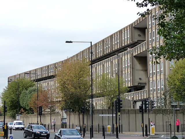
English: Robin Hood Gardens, Cotton Street The west side of the west block. Robin Hood Gardens is one of London's most notorious 1960s housing estates which is loathed by some but revered by others as a beacon of modern architecture. There are probably more people in the former camp than the latter. There are two blocks aligned roughly north-south with a patch of green space between them. They were designed by Alison and Peter Smithson in 1966-72, with Christopher Woodward and Ken Baker of the Greater London Council. The buildings embody the Smithsons' idea of "streets in the sky" and are an example of concrete Brutalism, with the pre-cast concrete being rough and shuttered. Pevsner comments that while being "impressively monumental" the scheme is also "inhumane" because of the high density, the narrowness of the decks and its proximity to busy roads on two sides.
Tower Hamlets Council plan to demolish the buildings and redevelop the site. A campaign by the Twentieth Century Society and others to halt this by applying for listed building status in 2008 was unsuccessful. |
| Data | |
| Fonte | From geograph.org.uk |
| Autore | Stephen Richards |
| Attribuzione (richiesto dalla licenza) | Stephen Richards / Robin Hood Gardens, Cotton Street (1) / |
| Luogo dello scatto | | Posizione di questa e altre immagini su: OpenStreetMap |
|---|
_heading:22.00&language=it)
| Posizione del soggetto | | Posizione di questa e altre immagini su: OpenStreetMap |
|---|
_heading:22.00&language=it)
Licenza
[modifica]

|
Questa immagine proviene dalla collezione del progetto Geograph. Vedi questa fotografia sul sito web di Geograph per visualizzare i dettagli relativi al fotografo. Il copyright di questa immagine appartiene a Stephen Richards ed è pubblicata secondo i termini della licenza Creative Commons Attribuzione-Condividi allo stesso modo 2.0.
|
Questo file è disponibile in base alla licenza Creative Commons Attribuzione-Condividi allo stesso modo 2.0 Generico
Attribuzione: Stephen Richards
- Tu sei libero:
- di condividere – di copiare, distribuire e trasmettere quest'opera
- di modificare – di adattare l'opera
- Alle seguenti condizioni:
- attribuzione – Devi fornire i crediti appropriati, un collegamento alla licenza e indicare se sono state apportate modifiche. Puoi farlo in qualsiasi modo ragionevole, ma non in alcun modo che suggerisca che il licenziante approvi te o il tuo uso.
- condividi allo stesso modo – Se remixi, trasformi o sviluppi il materiale, devi distribuire i tuoi contributi in base alla stessa licenza o compatibile all'originale.
Cronologia del file
Fare clic su un gruppo data/ora per vedere il file come si presentava nel momento indicato.
| Data/Ora | Miniatura | Dimensioni | Utente | Commento | |
|---|---|---|---|---|---|
| attuale | 00:53, 3 mar 2011 | | 640 × 480 (142 KB) | GeographBot (discussione | contributi) | == {{int:filedesc}} == {{Information |description={{en|1=Robin Hood Gardens, Cotton Street The west side of the west block. Robin Hood Gardens is one of London's most notorious 1960s housing estates which is loathed by some but revered by others as a beac |
Impossibile sovrascrivere questo file.
Utilizzo del file
Nessuna pagina utilizza questo file.
Utilizzo globale del file
Anche i seguenti wiki usano questo file:
- Usato nelle seguenti pagine di en.wikipedia.org:
- Usato nelle seguenti pagine di es.wikipedia.org:
- Usato nelle seguenti pagine di it.wikipedia.org: