File:S73-15171.jpg
Jump to navigation
Jump to search

Size of this preview: 451 × 599 pixels. Other resolutions: 181 × 240 pixels | 361 × 480 pixels | 578 × 768 pixels | 771 × 1,024 pixels | 1,542 × 2,048 pixels | 6,176 × 8,204 pixels.
Original file (6,176 × 8,204 pixels, file size: 6.19 MB, MIME type: image/jpeg)
Captions
Captions
Add a one-line explanation of what this file represents
Summary[edit]
| Description |
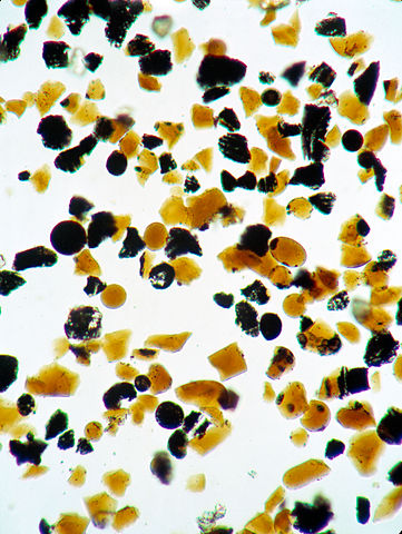
English: S73-15171 (4 Jan. 1973) --- These orange glass spheres and fragments are the finest particles ever brought back from the moon. Ranging in size from 20 to 45 microns (about 1/1000 of an inch) the particles are magnified 160 times in this photomicrograph made in the Lunar Receiving Laboratory at the Manned Spacecraft Center. The orange soil was brought back from the Taurus-Littrow landing site by the Apollo 17 crewmen. Scientist-astronaut Harrison H. "Jack" Schmitt discovered the orange soil at Shorty Crater during the second Apollo 17 extravehicular activity (EVA). This lunar material is being studied and analyzed by scientists in the LRL. The orange particles in this photomicrograph, which are intermixed with black and black-speckled grains, are about the same size as the particles that compose silt on Earth. Chemical analysis of the orange soil material has shown the sample to be similar to some of the samples brought back from the Apollo 11 (Sea of Tranquility) site several hundred miles to the southwest. Like those samples, it is rich in titanium (8%) and iron oxide (22%). But unlike the Apollo 11 samples, the orange soil is unexplainably rich in zinc -- an anomaly that has scientists in a quandary. This Apollo 17 sample is not high in volatile elements, nor do the minerals contain substantial amounts of water. These would have provided strong evidence of volcanic activity. On the other hand, the lack of agglutinates (rocks made up of a variety of minerals cemented together) indicates that the orange glass is probably not the product of meteorite impact -- strengthening the argument that the glass was produced by volcanic activity. |
| Date | |
| Source | http://spaceflight.nasa.gov/gallery/ |
| Author | NASA |
| Camera location | | View this and other nearby images on: OpenStreetMap |
|---|
This image or video was catalogued by one of the centers of the United States National Aeronautics and Space Administration (NASA) under Photo ID: S73-15171. This tag does not indicate the copyright status of the attached work. A normal copyright tag is still required. See Commons:Licensing. Other languages:
|
Licensing[edit]
| This file is in the public domain in the United States because it was solely created by NASA. NASA copyright policy states that "NASA material is not protected by copyright unless noted". (See Template:PD-USGov, NASA copyright policy page or JPL Image Use Policy.) | ||
 |
Warnings:
|
File history
Click on a date/time to view the file as it appeared at that time.
| Date/Time | Thumbnail | Dimensions | User | Comment | |
|---|---|---|---|---|---|
| current | 12:30, 21 June 2013 | | 6,176 × 8,204 (6.19 MB) | Askeuhd (talk | contribs) | User created page with UploadWizard |
You cannot overwrite this file.
File usage on Commons
There are no pages that use this file.
File usage on other wikis
The following other wikis use this file:
- Usage on fr.wikipedia.org
- Usage on ru.wikipedia.org
- Usage on uk.wikipedia.org