File:Sector Map Gov Pyithu Hluttaw Election Results 2015-2018 IFES MIMU1351v03 10Sep2019 A3.pdf

Tập tin gốc (1.754×2.479 điểm ảnh, kích thước tập tin: 1,57 MB, kiểu MIME: application/pdf)
Chú thích
Chú thích
Miêu tả
[sửa]| Miêu tả |
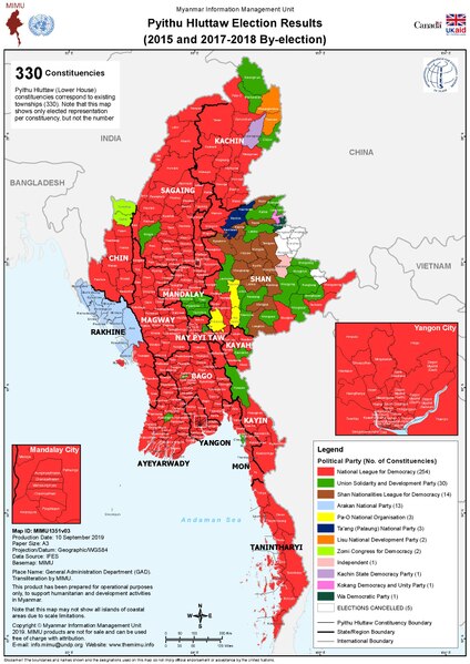
English: Electoral map created by the Myanmar Information Management Unit (MIMU). See the MIMU website and file name for more details. |
| Ngày | See map text |
| Nguồn gốc | Myanmar Information Management Unit (MIMU) |
| Tác giả | United Nations Development Programme (UNDP) |
Giấy phép
[sửa]| This image is a map derived from a United Nations map.
Unless stated otherwise, UN maps are to be considered in the public domain. This applies worldwide. UN maps are, in principle, open source material and you can use them in your work or for making your own map. UN requests however that you delete the UN name, logo and reference number upon any modification to the map. Content of your map will be your responsibility. You can state in your publication, if you wish, something like: based on UN map … (map name, map number, revision number and date). See: Geospatial Information Section. And: Geospatial, location data for a better world. |
 |
Lịch sử tập tin
Nhấn vào ngày/giờ để xem nội dung tập tin tại thời điểm đó.
| Ngày/Giờ | Hình xem trước | Kích cỡ | Thành viên | Miêu tả | |
|---|---|---|---|---|---|
| hiện tại | 23:39, ngày 31 tháng 1 năm 2021 |  | 1.754×2.479 (1,57 MB) | RaviC (thảo luận | đóng góp) | Uploaded a work by United Nations Development Programme (UNDP) from [http://themimu.info/sector/governance Myanmar Information Management Unit (MIMU)] with UploadWizard |
Bạn không được phép ghi đè tập tin này.
Trang sử dụng tập tin
3 trang sau sử dụng tập tin này:
Sử dụng tập tin toàn cục
Những wiki sau đang sử dụng tập tin này:
- Trang sử dụng tại en.wikipedia.org
- Trang sử dụng tại es.wikipedia.org
- Trang sử dụng tại fr.wikipedia.org
- Trang sử dụng tại it.wikipedia.org
- Trang sử dụng tại my.wikipedia.org
- Trang sử dụng tại shn.wikipedia.org
- Trang sử dụng tại vi.wikipedia.org