File:Situation in Sievierodonetsk and Lysychansk.svg
Bước tới điều hướng
Bước tới tìm kiếm

Kích thước bản xem trước PNG này của tập tin SVG: 800×589 điểm ảnh. Độ phân giải khác: 320×236 điểm ảnh | 640×471 điểm ảnh | 1.024×754 điểm ảnh | 1.280×943 điểm ảnh | 2.560×1.886 điểm ảnh | 1.226×903 điểm ảnh.
Tập tin gốc (tập tin SVG, 1.226×903 điểm ảnh trên danh nghĩa, kích thước: 9,62 MB)
Chú thích
Chú thích
Ghi một dòng giải thích những gì có trong tập tin này
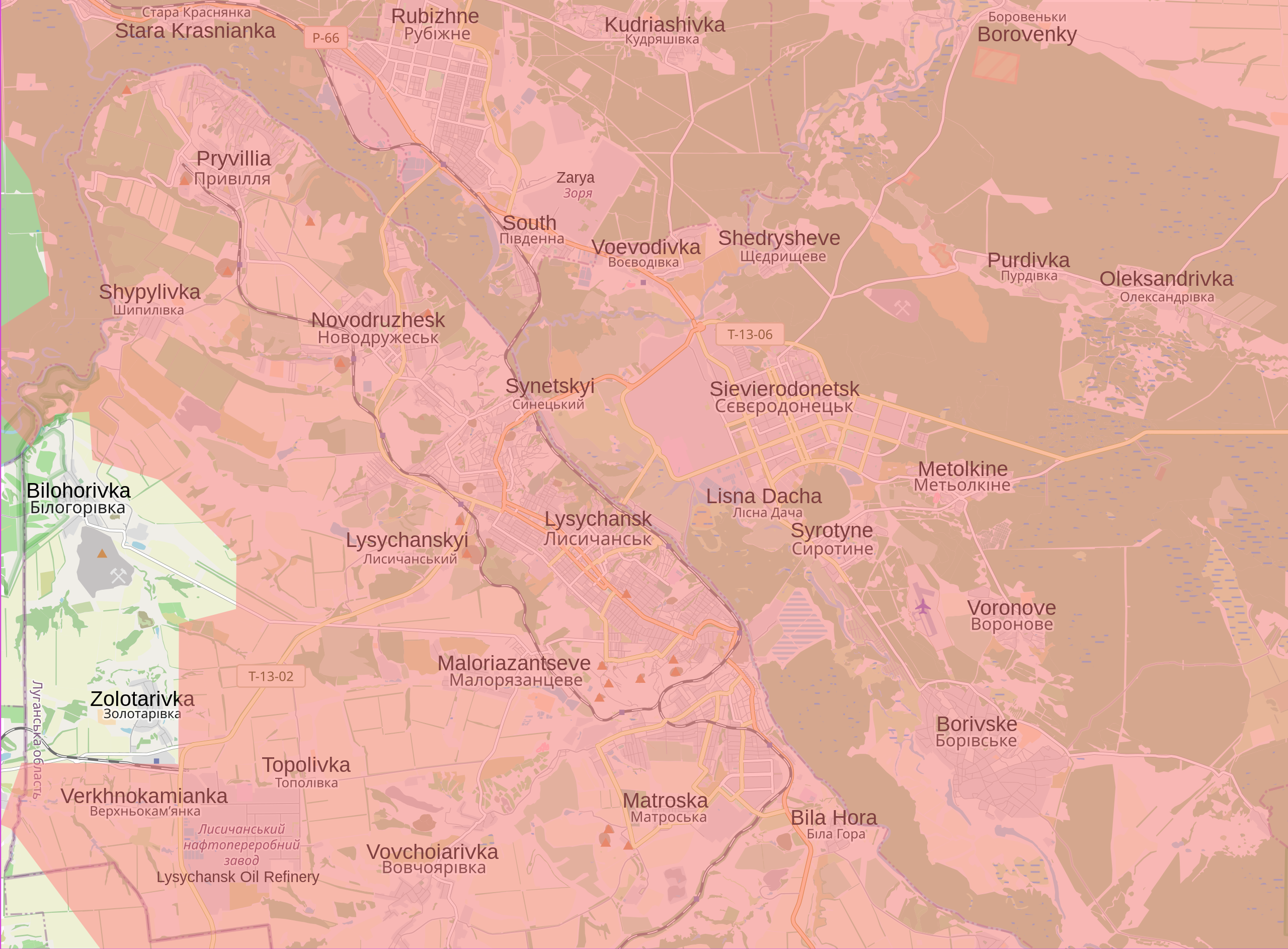
Current situation in and around Sievierodonetsk and Lysychansk
Miêu tả
[sửa]
| Miêu tả |
English: Map showing the current situation in and around Sievierodonetsk and Lysychansk. Land in red is controlled by Russia and the Luhansk and Donbas People's Republics. During the 2022 Russian invasion of Ukraine, Sievierodonetsk came under attack from Russian and Luhansk People's Republic forces, and the battle started on 6 May 2022. On 24 June, Ukrainian forces were ordered to withdraw from Sievierodonetsk and city fell the following day. This left the neighbouring Lysychansk as the only notable part of the Luhansk Oblast that remained under Ukrainian control. In the following days, Russia made advances south of Lysychansk, and entered the city on 25 June. Russia announced that it had control of Lysychansk on 2 July after seven days of fighting. This was initially denied by Ukraine, however, the Ukrainian general staff admitted on 3 July that it gave the order to withdraw from the city. The fall of Lysychansk means that the Luhansk People's Republic has complete control of the Luhansk Oblast. |
| Ngày | |
| Nguồn gốc |
Tác phẩm được tạo bởi người tải lên Control data from the Institute for the Study of War |
| Tác giả | Cyrobyte |
Giấy phép
[sửa]
| Lời miêu tả |
This map was created from OpenStreetMap project data, collected by the community. This map may be incomplete, and may contain errors. Don't rely solely on it for navigation. |
|||
| Ngày | (see file history) | |||
| Nguồn gốc | openstreetmap.org | |||
| Sáng tác |
OpenStreetMap contributors |
|||
| Giấy phép (Dùng lại tập tin) |
OpenStreetMap data is available under the Open Database License (details). Map tiles are licensed under the Creative Commons Attribution-ShareAlike 2.0 license (CC-BY-SA 2.0).
Tập tin này được phát hành theo Giấy phép Creative Commons Ghi công–Chia sẻ tương tự 2.0 Chung
|
|||
| Georeferencing | If inappropriate please set warp_status = skip to hide. |
Tôi, người giữ bản quyền tác phẩm này, từ đây phát hành nó theo giấy phép sau:
| Tập tin này được phân phối theo Creative Commons Hiến tặng vào Phạm vi Công cộng Toàn thế giới CC0. | |
| Người nào gán tài liệu này với tác phẩm nghĩa là đã hiến tác phẩm cho phạm vi công cộng bằng cách từ bỏ mọi quyền lợi của người đó đối với tác phẩm theo quy định của luật bản quyền, có hiệu lực trên toàn thế giới và các quyền lợi pháp lý phụ mà người đó có được trong tác phẩm, đến mức độ mà luật pháp cho phép. Bạn được tự do sao chép, phân phối, và biểu diễn tác phẩm này, tất cả đều không bắt buộc ghi công.
|
Lịch sử tập tin
Nhấn vào ngày/giờ để xem nội dung tập tin tại thời điểm đó.
| Ngày/Giờ | Hình xem trước | Kích cỡ | Thành viên | Miêu tả | |
|---|---|---|---|---|---|
| hiện tại | 00:21, ngày 28 tháng 1 năm 2023 | | 1.226×903 (9,62 MB) | Nahabino (thảo luận | đóng góp) | Update per ISW |
| 20:31, ngày 21 tháng 10 năm 2022 |  | 1.226×903 (9,62 MB) | Nahabino (thảo luận | đóng góp) | Update per ISW | |
| 22:20, ngày 5 tháng 10 năm 2022 |  | 1.226×903 (9,63 MB) | Nahabino (thảo luận | đóng góp) | Update per ISW | |
| 01:10, ngày 1 tháng 10 năm 2022 |  | 1.226×903 (9,64 MB) | Nahabino (thảo luận | đóng góp) | Update per ISW | |
| 14:14, ngày 28 tháng 9 năm 2022 |  | 1.226×903 (9,73 MB) | Nahabino (thảo luận | đóng góp) | Bilohorivka | |
| 00:42, ngày 4 tháng 7 năm 2022 |  | 1.226×903 (9,74 MB) | Cyrobyte (thảo luận | đóng góp) | Update | |
| 21:51, ngày 2 tháng 7 năm 2022 |  | 1.226×903 (9,74 MB) | Cyrobyte (thảo luận | đóng góp) | Update | |
| 03:15, ngày 2 tháng 7 năm 2022 |  | 1.226×903 (9,74 MB) | Cyrobyte (thảo luận | đóng góp) | Update | |
| 00:22, ngày 2 tháng 7 năm 2022 |  | 1.226×903 (9,74 MB) | Cyrobyte (thảo luận | đóng góp) | Fixed alignment of English labels | |
| 20:21, ngày 1 tháng 7 năm 2022 |  | 1.226×903 (9,73 MB) | Cyrobyte (thảo luận | đóng góp) | Update |
Bạn không được phép ghi đè tập tin này.
Trang sử dụng tập tin
16 trang sau sử dụng tập tin này:
- User:Jcornelius/Angola/2022 July 1-10
- User:Jcornelius/Angola/2022 June 1-10
- User:Jcornelius/Angola/2022 June 11-20
- User:Jcornelius/Angola/2022 June 21-30
- User:Jcornelius/Angola/2022 October 1-10
- User:Jcornelius/Angola/2022 October 21-31
- User:Jcornelius/Angola/2022 September 21-30
- User:Jcornelius/Angola/2023 January 21-31
- User:Magog the Ogre/Maps of conflicts/2022 July
- User:Magog the Ogre/Maps of conflicts/2022 June
- User:Magog the Ogre/Maps of conflicts/2022 October
- User:Magog the Ogre/Maps of conflicts/2022 September
- User:Magog the Ogre/Maps of conflicts/2023 January
- User:ביקורת/Rabbis/2023 January 28
- Category:Battle of Sievierodonetsk (2022)
- Category:War damages in Lysychansk (2022)
Sử dụng tập tin toàn cục
Những wiki sau đang sử dụng tập tin này:
- Trang sử dụng tại ar.wikipedia.org
- Trang sử dụng tại ca.wikipedia.org
- Trang sử dụng tại cs.wikipedia.org
- Trang sử dụng tại ja.wikipedia.org
- Trang sử dụng tại ro.wikipedia.org
- Trang sử dụng tại vi.wikipedia.org
- Trang sử dụng tại www.wikidata.org