File:Taínos.svg
Jump to navigation
Jump to search

Size of this PNG preview of this SVG file: 800 × 571 pixels. Other resolutions: 320 × 228 pixels | 640 × 457 pixels | 1,024 × 731 pixels | 1,280 × 914 pixels | 2,560 × 1,827 pixels | 863 × 616 pixels.
Original file (SVG file, nominally 863 × 616 pixels, file size: 556 KB)
Captions
Captions
Add a one-line explanation of what this file represents
Summary
[edit]
| Description |
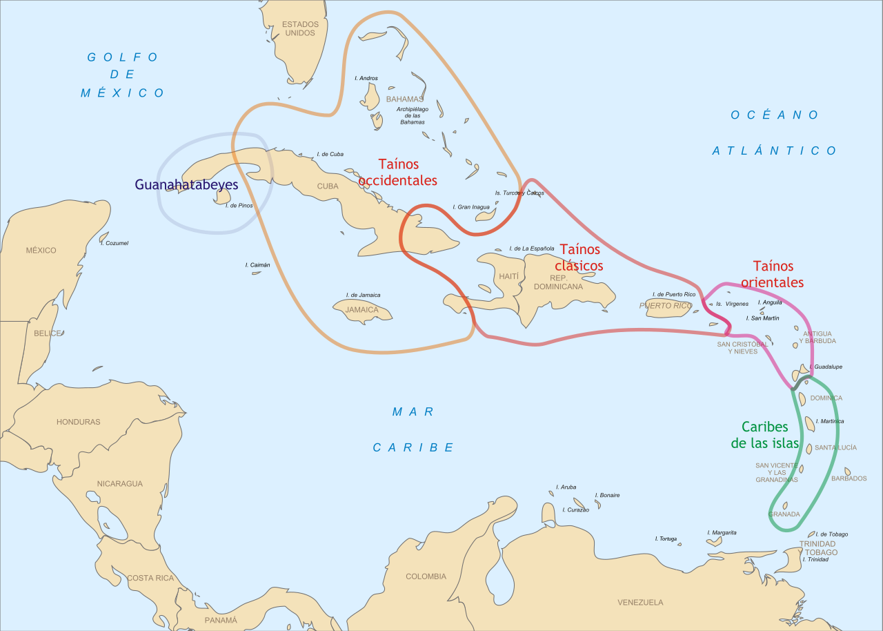
English: Distribution of Taino, Caribbean and Guanahatabey Arawaks in the Antilles, at the time of the arrival of the Spaniards. The map was reworked from information appearing in Saber Ver No. 21 (dedicated to Taino art), March-April 1995, p. 19. Español: Distribución de los arahuacos taínos, caribes y guanahatabeyes en las Antillas, en el tiempo de la llegada de los españoles. El mapa fue reelaborado a partir de información aparecida en Saber Ver No. 21 (dedicado al arte taíno), marzo-abril de 1995, p. 19. |
| Date | |
| Source | Own work |
| Author | Yavidaxiu |
| Permission (Reusing this file) |
See below (ver abajo) |
Licensing
[edit]
| I, the copyright holder of this work, release this work into the public domain. This applies worldwide. In some countries this may not be legally possible; if so: I grant anyone the right to use this work for any purpose, without any conditions, unless such conditions are required by law. |
File history
Click on a date/time to view the file as it appeared at that time.
| Date/Time | Thumbnail | Dimensions | User | Comment | |
|---|---|---|---|---|---|
| current | 17:20, 29 April 2011 | | 863 × 616 (556 KB) | Tyk (talk | contribs) | Fixing text |
| 04:06, 18 September 2008 |  | 863 × 616 (98 KB) | Yavidaxiu (talk | contribs) | {{Information |Description={{es|1=Distribución de los arahuacos taínos, caribes y guanahatabeyes en las Antillas, en el tiempo de la llegada de los españoles. El mapa fue reelaborado a partir de información aparecida en ''Saber Ver'' No. 21 (dedicado |
You cannot overwrite this file.
File usage on Commons
The following page uses this file:
File usage on other wikis
The following other wikis use this file:
- Usage on als.wikipedia.org
- Usage on ar.wikipedia.org
- Usage on arz.wikipedia.org
- Usage on bn.wikipedia.org
- Usage on br.wikipedia.org
- Usage on ca.wikipedia.org
- Usage on de.wikipedia.org
- Usage on en.wikipedia.org
- Usage on eo.wikipedia.org
- Usage on es.wikipedia.org
- Usage on eu.wikipedia.org
- Usage on frr.wikipedia.org
- Usage on fr.wikipedia.org
- Usage on hr.wikipedia.org
- Usage on ht.wikipedia.org
- Usage on id.wikipedia.org
- Usage on it.wikipedia.org
- Usage on ja.wikipedia.org
- Usage on ko.wikipedia.org
View more global usage of this file.