File:Tambon 8012.png
Jump to navigation
Jump to search
No higher resolution available.
Tambon_8012.png (300 × 350 pixels, file size: 17 KB, MIME type: image/png)
Captions
Captions
Add a one-line explanation of what this file represents
Summary
[edit]
| Description |
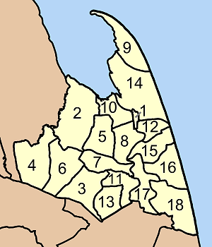
English: Map of Pak Pahang district, Nakhon Si Thammarat province, Thailand, with the communes (tambon) numbered.
|
| Source | Own work |
| Author | Ahoerstemeier |
Licensing
[edit]

|
Permission is granted to copy, distribute and/or modify this document under the terms of the GNU Free Documentation License, Version 1.2 or any later version published by the Free Software Foundation; with no Invariant Sections, no Front-Cover Texts, and no Back-Cover Texts. A copy of the license is included in the section entitled GNU Free Documentation License. |
| This file is licensed under the Creative Commons Attribution-Share Alike 3.0 Unported license. | ||
| ||
| This licensing tag was added to this file as part of the GFDL licensing update. |
This file is licensed under the Creative Commons Attribution-Share Alike 1.0 Generic license.
- You are free:
- to share – to copy, distribute and transmit the work
- to remix – to adapt the work
- Under the following conditions:
- attribution – You must give appropriate credit, provide a link to the license, and indicate if changes were made. You may do so in any reasonable manner, but not in any way that suggests the licensor endorses you or your use.
- share alike – If you alter, transform, or build upon this work, you must distribute the resulting work under the same license as the original.
File history
Click on a date/time to view the file as it appeared at that time.
| Date/Time | Thumbnail | Dimensions | User | Comment | |
|---|---|---|---|---|---|
| current | 12:01, 22 June 2006 | | 300 × 350 (17 KB) | Ahoerstemeier (talk | contribs) | Map of Pak Pahang district, Nakhon Si Thammarat province, Thailand, with the communes (tambon) numbered. #Pak Phanang (ปากพนัง) #Khlong Noi (คลองน้อย) #Pa Rakam (ป่าระกำ) #Chamao (ชะเมา) #Khlong Krabu |
You cannot overwrite this file.
File usage on Commons
The following page uses this file:
File usage on other wikis
The following other wikis use this file:
- Usage on de.wikipedia.org
- Usage on en.wikipedia.org
- Usage on ro.wikipedia.org
- Usage on th.wikipedia.org
- Usage on vi.wikipedia.org