File:Tectonic map Mediterranean EN.svg
Jump to navigation
Jump to search

Size of this PNG preview of this SVG file: 800 × 447 pixels. Other resolutions: 320 × 179 pixels | 640 × 358 pixels | 1,024 × 572 pixels | 1,280 × 715 pixels | 2,560 × 1,430 pixels.
Original file (SVG file, nominally 1,280 × 715 pixels, file size: 623 KB)
Captions
Captions
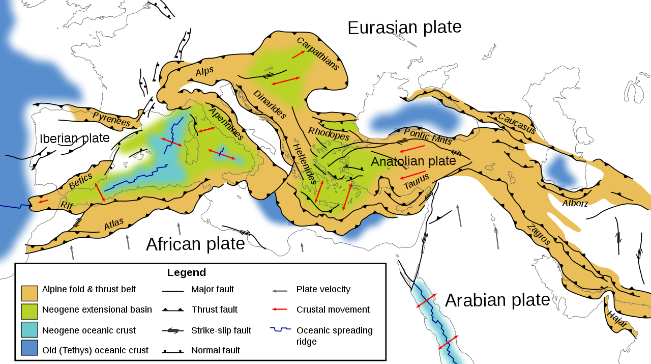
Tectonic map of southern Europe, North Africa and the Middle East
Summary[edit]
| Description |
English: Tectonic map of southern Europe, North Africa and the Middle East, showing tectonic structures of the western Alpide mountain belt. Only Alpine (tertiary) structures are shown. |
| Date | |
| Source | Own work |
| Author | Woudloper |
| Other versions |
[]
|


|
This SVG file contains embedded text that can be translated into your language, using any capable SVG editor, text editor or the SVG Translate tool. For more information see: About translating SVG files. |
Licensing[edit]
This file is licensed under the Creative Commons Attribution-Share Alike 1.0 Generic license.
- You are free:
- to share – to copy, distribute and transmit the work
- to remix – to adapt the work
- Under the following conditions:
- attribution – You must give appropriate credit, provide a link to the license, and indicate if changes were made. You may do so in any reasonable manner, but not in any way that suggests the licensor endorses you or your use.
- share alike – If you alter, transform, or build upon this work, you must distribute the resulting work under the same license as the original.
File history
Click on a date/time to view the file as it appeared at that time.
| Date/Time | Thumbnail | Dimensions | User | Comment | |
|---|---|---|---|---|---|
| current | 16:07, 9 June 2009 | | 1,280 × 715 (623 KB) | Woudloper (talk | contribs) | removed shade behind strik-slip symbols |
| 15:19, 9 June 2009 |  | 1,280 × 715 (625 KB) | Woudloper (talk | contribs) | {{Information |Description={{en|1=Tectonic map of southern Europe and the Middle East, showing tectonic structures of the western Alpide mountain belt. Only Alpine (Tertiary) structures are shown.}} |Source=Eigen |
You cannot overwrite this file.
File usage on Commons
The following 12 pages use this file:
- Atlas Mountains
- User:Woudloper
- File:Tectonic map Mediterranean DE.svg
- File:Tectonic map Mediterranean EN.svg
- File:Tectonic map Mediterranean FR.svg
- File:Tectonic map Mediterranean He.jpg
- File:Tectonic map Mediterranean IT.svg
- File:Tectonic map Mediterranean NL.svg
- File:Tectonic map Mediterranean UK.svg
- File:Tectonic map Mediterranean es.svg
- Template:Other versions/Tectonic map Mediterranean
- Category:Alpine orogeny
File usage on other wikis
The following other wikis use this file:
- Usage on ar.wikipedia.org
- Usage on az.wikipedia.org
- Usage on ba.wikipedia.org
- Usage on be.wikipedia.org
- Usage on cs.wikipedia.org
- Usage on de.wikipedia.org
- Usage on en.wikipedia.org
- Usage on fa.wikipedia.org
- Usage on gl.wikipedia.org
- Usage on hr.wikipedia.org
- Usage on hu.wikipedia.org
- Usage on ja.wikipedia.org
- Usage on ja.wikibooks.org
- Usage on ka.wikipedia.org
- Usage on ko.wikipedia.org
- Usage on ku.wikipedia.org
- Usage on ml.wikipedia.org
- Usage on nn.wikipedia.org
- Usage on no.wikipedia.org
- Usage on ro.wikipedia.org
- Usage on ru.wikipedia.org
- Usage on sh.wikipedia.org
- Usage on simple.wikipedia.org
- Usage on sk.wikipedia.org
- Usage on tr.wikipedia.org
- Usage on vi.wikipedia.org
- Usage on www.wikidata.org
- Usage on zh.wikipedia.org
Categories:
- English-language SVG maps
- SVG geology
- Alpine orogeny
- Atlas Mountains
- Cordilleras Béticas
- Maps of Rhodope
- Maps of Anatolia
- Taurus Mountains
- Maps of the Caucasus
- Armenian Highland
- Maps of the Zagros Mountains
- Maps of the Alborz
- Geological maps of Europe
- Geological maps of Spain
- Geological maps of France
- Geological maps of the Alps
- Geological maps of the Dinaric Alps
- Maps of the Carpathian Mountains
- SVG maps of Turkey
- SVG maps of the Middle East
- Tectonics maps
- Geological maps of the Mediterranean Sea
- Geology of Morocco
- Geological maps of Morocco
- Structural geology of Turkey
- Structural geology of Italy
- Structural geology of France
- Structural geology of Spain
- Structural geology of Greece
- Geology of the Persian Gulf
- Hellenic Trench
- Alpide belt
- Geology of the Mediterranean Sea
- Neogene geology
- Neogene geology of Italy
- Neogene geology of Spain
- Neogene geology of Europe
- Neogene geology of Asia
- Iberian tectonic plate
- Geological maps of Iraq