File:Thüringer Wald - Deutsche Mittelgebirge, Serie A-de.png

Pradinė rinkmena (2 200 × 1 850 taškų, rinkmenos dydis: 5,3 MiB, MIME tipas: image/png)
Captions
Captions
Aprašymas[keisti]
| Aprašymas |
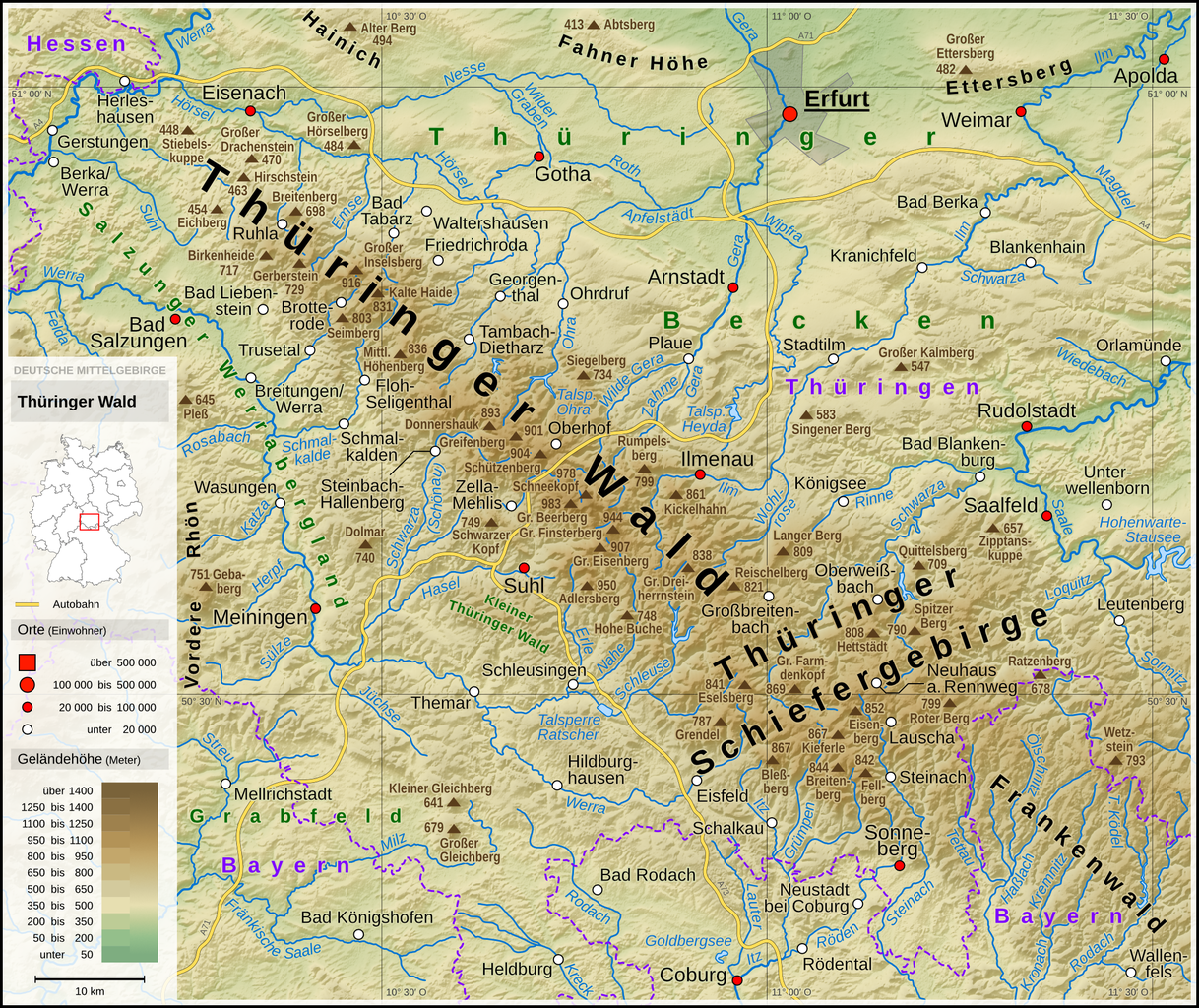
English: Topographic map of the Thuringian Forest
Deutsch: Topografische Karte des Thüringer Waldes |
||||||||||||||||||
| Data | |||||||||||||||||||
| Šaltinis |
Own work using: |
||||||||||||||||||
| Autorius | Thoroe | ||||||||||||||||||
| Kitos versijos |
 Topographic maps of German low mountain ranges (A series)
This map series aims to show the major low mountain ranges of Germany in a uniform design. All maps are created on the same scale, and the background reliefs base upon the same color scheme. The reliefs are also available as separate files. You can find the making-of one of the maps in the German language Wikipedia (German only).
|
||||||||||||||||||


_-_Deutsche_Mittelgebirge,_Serie_A-de.png)
_-_Deutsche_Mittelgebirge,_Serie_A-de.png)
_-_Deutsche_Mittelgebirge,_Serie_A-de.png)
_-_Deutsche_Mittelgebirge,_Serie_A-de.png)
_-_Deutsche_Mittelgebirge,_Serie_A-de.png)
_-_Deutsche_Mittelgebirge,_Serie_A-de.png)
_-_Deutsche_Mittelgebirge,_Serie_A-de.png)
_-_Deutsche_Mittelgebirge,_Serie_A-de.png)
_-_Deutsche_Mittelgebirge,_Serie_A-de.png)
_-_Deutsche_Mittelgebirge,_Serie_A-de.png)
_-_Deutsche_Mittelgebirge,_Serie_A-de.png)
_-_Deutsche_Mittelgebirge,_Serie_A-de.png)
_-_Deutsche_Mittelgebirge,_Serie_A-de.png)
_-_Deutsche_Mittelgebirge,_Serie_A-de.png)
_-_Deutsche_Mittelgebirge,_Serie_A-de.png)
_-_Deutsche_Mittelgebirge,_Serie_A-de.png)
_-_Deutsche_Mittelgebirge,_Serie_A-de.png)
_-_Deutsche_Mittelgebirge,_Serie_A-de.png)
_-_Deutsche_Mittelgebirge,_Serie_A-de.png)
_-_Deutsche_Mittelgebirge,_Serie_A-de.png)
_-_Deutsche_Mittelgebirge,_Serie_A-de.png)
_-_Deutsche_Mittelgebirge,_Serie_A-de.png)
_-_Deutsche_Mittelgebirge,_Serie_A-de.png)
_-_Deutsche_Mittelgebirge,_Serie_A-de.png)
_-_Deutsche_Mittelgebirge,_Serie_A-de.png)
_-_Deutsche_Mittelgebirge,_Serie_A-de.png)
_-_Deutsche_Mittelgebirge,_Serie_A-de.png)
_-_Deutsche_Mittelgebirge,_Serie_A-de.png)
_-_Deutsche_Mittelgebirge,_Serie_A-de.png)
_-_Deutsche_Mittelgebirge,_Serie_A-de.png)
_-_Deutsche_Mittelgebirge,_Serie_A-de.png)
_-_Deutsche_Mittelgebirge,_Serie_A-de.png)
| This work contains information from OpenStreetMap, which is made available under the Open Database License (ODbL).
The ODbL does not require any particular license for maps produced from ODbL data. Prior to 1 August 2020, map tiles produced by the OpenStreetMap Foundation were licensed under the CC-BY-SA-2.0 license. Maps produced by other people may be subject to other licences. |

|
This map has been made or improved in the German Kartenwerkstatt (Map Lab). You can propose maps to improve as well.
|
Licencija[keisti]
- Jūs galite:
- dalintis – kopijuoti, platinti bei persiųsti šį darbą
- pri(si)taikyti – adaptuoti darbą
- Su šiomis sąlygomis:
- autoriaus nurodymas – Turite pateikti atitinkamą kreditą, pateikti nuorodą į licenciją ir nurodyti, ar buvo atlikti pakeitimai. Tai galite padaryti bet kokiu būdu, bet ne taip, kad licencijos išdavėjas patvirtintų jus ar jūsų naudojimą.
- dalinkis panašiai – Jei perdirbsite, redaguosite ar atkursite šį darbą, jį galėsite platinti tik su tokia pačia ar panašia į šią licencija.
| Annotations | This image is annotated: View the annotations at Commons |
Rinkmenos istorija
Paspauskite ant datos/laiko, kad pamatytumėte rinkmeną tokią, kokia ji buvo tuo metu.
| Data/Laikas | Miniatiūra | Matmenys | Naudotojas | Paaiškinimas | |
|---|---|---|---|---|---|
| dabartinis | 19:15, 13 kovo 2022 | | 2 200 × 1 850 (5,3 MiB) | Thoroe (aptarimas | indėlis) | + Kleiner Thüringer Wald |
| 10:38, 8 kovo 2022 |  | 2 200 × 1 850 (5,3 MiB) | Thoroe (aptarimas | indėlis) | Detailänderungen | |
| 16:58, 6 kovo 2022 |  | 2 200 × 1 850 (5,29 MiB) | Thoroe (aptarimas | indėlis) | {{Information |Description={{en|1=Topographic map of the Thuringian Forest}} {{de|1=Topografische Karte des Thüringer Waldes}} |Source={{Own using}} *[http://gmt.soest.hawaii.edu Generic Mapping Tools (GMT)] with [http://dds.cr.usgs.gov/srtm/version2_1/SRTM3/ SRTM3 V2.1 data] *[http://www.openstreetmap.org OpenStreetMap] data *File:Karte_Bundesrepublik_Deutschland.svg by David Liuzzo |Date=2022-03-06 |Author= [[User:... |
Jūs negalite perrašyti šios rinkmenos.
Rinkmenos naudojimas
Šie puslapiai naudoja šią rinkmeną:
- File:Bayerischer Wald (Relief) - Deutsche Mittelgebirge, Serie A-de.png
- File:Bayerischer Wald (Relief und Gewässer) - Deutsche Mittelgebirge, Serie A-de.png
- File:Bayerischer Wald - Deutsche Mittelgebirge, Serie A-de.png
- File:Deutsche Mittelgebirge, Serie A - Abdeckung.svg
- File:Eifel (Relief) - Deutsche Mittelgebirge, Serie A-de.png
- File:Eifel (Relief und Gewässer) - Deutsche Mittelgebirge, Serie A-de.png
- File:Eifel - Deutsche Mittelgebirge, Serie A-de.png
- File:Harz (Relief) - Deutsche Mittelgebirge, Serie A-de.png
- File:Harz (Relief und Gewässer) - Deutsche Mittelgebirge, Serie A-de.png
- File:Harz - Deutsche Mittelgebirge, Serie A-de.png
- File:Hunsrück (Relief) - Deutsche Mittelgebirge, Serie A-de.png
- File:Hunsrück (Relief und Gewässer) - Deutsche Mittelgebirge, Serie A-de.png
- File:Hunsrück - Deutsche Mittelgebirge, Serie A-de.png
- File:Oberpfälzer Wald (Relief) - Deutsche Mittelgebirge, Serie A-de.png
- File:Oberpfälzer Wald (Relief und Gewässer) - Deutsche Mittelgebirge, Serie A-de.png
- File:Oberpfälzer Wald - Deutsche Mittelgebirge, Serie A-de.png
- File:Odenwald (Relief) - Deutsche Mittelgebirge, Serie A-de.png
- File:Odenwald (Relief und Gewässer) - Deutsche Mittelgebirge, Serie A-de.png
- File:Odenwald - Deutsche Mittelgebirge, Serie A-de.png
- File:Rhön (Relief) - Deutsche Mittelgebirge, Serie A-de.png
- File:Rhön (Relief und Gewässer) - Deutsche Mittelgebirge, Serie A-de.png
- File:Rhön - Deutsche Mittelgebirge, Serie A-de.png
- File:Rothaargebirge (Relief) - Deutsche Mittelgebirge, Serie A-de.png
- File:Rothaargebirge (Relief und Gewässer) - Deutsche Mittelgebirge, Serie A-de.png
- File:Rothaargebirge - Deutsche Mittelgebirge, Serie A-de.png
- File:Schwarzwald (Relief) - Deutsche Mittelgebirge, Serie A-de.png
- File:Schwarzwald (Relief und Gewässer) - Deutsche Mittelgebirge, Serie A-de.png
- File:Schwarzwald - Deutsche Mittelgebirge, Serie A-de.png
- File:Schwäbische Alb (Relief) - Deutsche Mittelgebirge, Serie A-de.png
- File:Schwäbische Alb (Relief und Gewässer) - Deutsche Mittelgebirge, Serie A-de.png
- File:Schwäbische Alb - Deutsche Mittelgebirge, Serie A-de.png
- File:Spessart (Relief) - Deutsche Mittelgebirge, Serie A-de.png
- File:Spessart (Relief und Gewässer) - Deutsche Mittelgebirge, Serie A-de.png
- File:Spessart - Deutsche Mittelgebirge, Serie A-de.png
- File:Taunus (Relief) - Deutsche Mittelgebirge, Serie A-de.png
- File:Taunus (Relief und Gewässer) - Deutsche Mittelgebirge, Serie A-de.png
- File:Taunus - Deutsche Mittelgebirge, Serie A-de.png
- File:Teutoburger Wald (Relief) - Deutsche Mittelgebirge, Serie A-de.png
- File:Teutoburger Wald (Relief und Gewässer) - Deutsche Mittelgebirge, Serie A-de.png
- File:Teutoburger Wald - Deutsche Mittelgebirge, Serie A-de.png
- File:Thüringer Wald (Relief) - Deutsche Mittelgebirge, Serie A-de.png
- File:Thüringer Wald (Relief und Gewässer) - Deutsche Mittelgebirge, Serie A-de.png
- File:Thüringer Wald - Deutsche Mittelgebirge, Serie A-de.png
- File:Vogelsberg (Relief) - Deutsche Mittelgebirge, Serie A-de.png
- File:Vogelsberg (Relief und Gewässer) - Deutsche Mittelgebirge, Serie A-de.png
- File:Vogelsberg - Deutsche Mittelgebirge, Serie A-de.png
- File:Westerwald (Relief) - Deutsche Mittelgebirge, Serie A-de.png
- File:Westerwald (Relief und Gewässer) - Deutsche Mittelgebirge, Serie A-de.png
- File:Westerwald - Deutsche Mittelgebirge, Serie A-de.png
- Template:Topographic maps of German low mountain ranges (Mittelgebirge), A series
Visuotinis rinkmenos naudojimas
Ši rinkmena naudojama šiose viki svetainėse:
- Naudojama bg.wikipedia.org
- Naudojama ceb.wikipedia.org
- Naudojama da.wikipedia.org
- Naudojama de.wikipedia.org
- Naudojama en.wikipedia.org
- Naudojama eo.wikipedia.org
- Naudojama es.wikipedia.org
- Naudojama et.wikipedia.org
- Naudojama fa.wikipedia.org
- Naudojama fr.wikipedia.org
- Naudojama it.wikipedia.org
- Naudojama lt.wikipedia.org
- Naudojama nl.wikipedia.org
- Naudojama nn.wikipedia.org
- Naudojama no.wikipedia.org
- Naudojama pl.wikipedia.org
- Naudojama sl.wikipedia.org
- Naudojama sv.wikipedia.org