File:Tokyo L7 lrg.jpg
Bước tới điều hướng
Bước tới tìm kiếm

Kích thước hình xem trước: 600×600 điểm ảnh. Độ phân giải khác: 240×240 điểm ảnh | 480×480 điểm ảnh | 1.000×1.000 điểm ảnh.
Tập tin gốc (1.000×1.000 điểm ảnh, kích thước tập tin: 511 kB, kiểu MIME: image/jpeg)
Chú thích
Chú thích
Ghi một dòng giải thích những gì có trong tập tin này
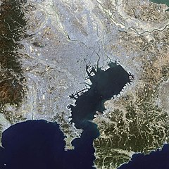
Satellite photo of Tokyo Bay (2002)
Miêu tả[sửa]
| Miêu tả |
English: This false-color Landsat 7 image shows (a large part of) the greater Tokyo metropolitan area, situated on the eastern shore of the Japanese island of Honshu. The large Tokyo Bay dominates the center of this scene, and if you look closely you can see boats and their wakes on the water. The greater Tokyo area fans out in a crescent shape around the western, northern, and eastern shores of Tokyo Bay. Greater Tokyo is bordered to the west by rugged mountains and to the east by the vast expanse of the Pacific Ocean.
The greater metropolis area is comprised of Tokyo prefecture, situated on the northwestern shore of Tokyo Bay, and the three neighboring prefectures of Kanagawa to the south, Saitama to the north, and Chiba to the east and southeast across Tokyo Bay. Over the last 400 years, Japan’s National Capital Region has evolved into a large, self-governing unit consisting of 26 cities, 5 towns, and 8 villages. The region is home to some 38 million people in 2018 (more than a quarter of Japan’s whole population) in a metropolitan area spanning 14,034 square km. 日本語: 東京湾の衛星画像(2002年)人工衛星「NASA Earth Observatory」による。 |
| Ngày | |
| Nguồn gốc | Earth Observatory |
| Tác giả | Image courtesy Ron Beck, USGS Eros Data Center Satellite Systems Branch |
Giấy phép[sửa]
| This file is in the public domain in the United States because it was solely created by NASA. NASA copyright policy states that "NASA material is not protected by copyright unless noted". (See Template:PD-USGov, NASA copyright policy page or JPL Image Use Policy.) | ||
 |
Warnings:
|
Lịch sử tập tin
Nhấn vào ngày/giờ để xem nội dung tập tin tại thời điểm đó.
| Ngày/Giờ | Hình xem trước | Kích cỡ | Thành viên | Miêu tả | |
|---|---|---|---|---|---|
| hiện tại | 14:25, ngày 18 tháng 11 năm 2008 | | 1.000×1.000 (511 kB) | Jyusin (thảo luận | đóng góp) | {{Information |Description={{en|1=Tokyo}} {{ja|1=東京}} |Source=[http://earthobservatory.nasa.gov/IOTD/view.php?id=2854 Earth Observatory] |Author=NASA |Date= |Permission= |other_versions= }} <!--{{ImageUpload|full}}--> |
Bạn không được phép ghi đè tập tin này.
Trang sử dụng tập tin
Không có trang nào sử dụng tập tin này.
Sử dụng tập tin toàn cục
Những wiki sau đang sử dụng tập tin này:
- Trang sử dụng tại az.wikipedia.org
- Trang sử dụng tại de.wikipedia.org
- Trang sử dụng tại es.wikipedia.org
- Trang sử dụng tại fr.wikipedia.org
- Trang sử dụng tại hu.wikipedia.org
- Trang sử dụng tại it.wikipedia.org
- Trang sử dụng tại ja.wikipedia.org
- Trang sử dụng tại pt.wikipedia.org
- Trang sử dụng tại simple.wikipedia.org
- Trang sử dụng tại tr.wikipedia.org
- Trang sử dụng tại vi.wikipedia.org
- Trang sử dụng tại zh.wikipedia.org